Chippewa Trail
No. 440
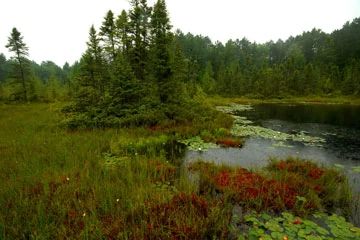
Photo by Josh Mayer
Chippewa Trail features a mosaic of northern mesic, dry-mesic, wet-mesic and wet forest and open bog communities with small acid bog ponds. Overall, the forest is of natural origin that, if allowed to age without manipulations, will increase in naturalness and approach old-growth conditions. Significant upland forest types include older-growth hemlock and hemlock hardwoods, along with mature white and red pine forest that has significant white pine reproduction. What is exceptional about this site is the evidence of natural processes functioning including successional changes, natural levels of disease, and natural regeneration of native species.
The undisturbed kettle bog complex consists of a small, shallow soft-water seepage lake, sphagnum moss mat, ericaceous shrubs, sedges, and scattered small swamp conifers. GroundThe ground includes rattlesnake manna grass, tussock cotton grass, moccasin flower, marsh cinquefoil, bog buckbean, and rose pogonia. Throughout this site, community integrity is sustained and at nearly 900 acres, it approaches a size in which landscape functions and processes can occur. This site is also linked to the nearby Headwaters site at its north end and several other SNAs including Memorial Grove Hemlocks and Tucker Lake. Together, these comprise an important resource for preserving intact native communities. Chippewa Trail is owned by the US Forest Service and was designated a State Natural Area in 2007.
Very few State Natural Areas have public facilities, but nearly all are open for a variety of recreational activities as indicated below. Generally, there are no picnic areas, restrooms, or other developments. Parking lots or designated parking areas are noted on individual SNA pages and maps. If a developed trail is present, it will normally be noted on the SNA map and/or under the Maps tab. A compass and topographic map or a GPS unit are useful tools for exploring larger, isolated SNAs.
The good majority of SNAs are isolated and have few or no facilities. Some SNAs have vehicle access lanes or parking lots, but their accessibility may vary depending on weather conditions. Parking lots and lanes are not plowed during winter. Hiking trails may be nonexistent or consist of undeveloped footpaths. A GPS unit or compass and a detailed topographic map are useful tools for exploring larger SNAs.
Non-DNR lands
Entrance fees: For non-DNR-owned SNAs, we are unaware of any vehicle or admission fees. However, please contact the landowner for more information.
Hunting and trapping
Other activities
Other allowable activities such as - but not limited to camping, geocaching and bicycling are determined by the landowner. Please contact them directly or visit their websites for details.
Location
Within the Chequamegon-Nicolet National Forest, Vilas County. T40N-R4E, Sections 17, 20, 21, 28, 29. 897 acres.
Driving directions
This site is located 15 miles west of Woodruff and 20 miles east of Park Falls, WI. Access is via State Highway 70 to Forest Road 509 (Chippewa Trail).
The DNR's state natural areas program is comprised of lands owned by the state, private conservation organizations, municipalities, other governmental agencies, educational institutions and private individuals. While the majority of SNAs are open to the public, access may vary according to individual ownership policies. Public use restrictions may apply due to public safety, or to protect endangered or threatened species or unique natural features. Lands may be temporarily closed due to specific management activities.
Users are encouraged to contact the landowner for more specific details. The data shown on these maps have been obtained from various sources, and are of varying age, reliability, and resolution. The data may contain errors or omissions and should not be interpreted as a legal representation of legal ownership boundaries. To create your custom map where you can zoom to a specific location, please use the DNR's Mapping Application.
Chippewa Trail is owned by: US Forest Service