Cherokee Marsh
No. 130
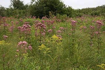
Photo by Josh Mayer
Cherokee Marsh is part of an extensive wetland complex of more than 2,000 acres. The north portion has been classified as a fen although it contains species characteristic of low prairies, shrub-carr, bogs, and sedge meadows. Southward are areas of the shrubby meadow where about half of the cover is bog birch, willows, and dogwood. Most of the southern portion has been ditched. In several areas dried by the ditching, the community composition is more like a wet prairie. Some areas along the southwest and southeast borders are quite disturbed with canary grass or nettles dominating. The hydrology of the area is complex as evidenced by the changing community structure on level topography. The site is used by many species of mammals and birds. Management activities include brushing, burning, and reestablishing normal hydrological systems. Cherokee Marsh is owned jointly by the City of Madison and the DNR and was designated a State Natural Area in 1976.
Very few State Natural Areas have public facilities, but nearly all are open for a variety of recreational activities as indicated below. Generally, there are no picnic areas, restrooms, or other developments. Parking lots or designated parking areas are noted on individual SNA pages and maps. If a developed trail is present, it will normally be noted on the SNA map and/or under the Maps tab. A compass and topographic map or a GPS unit are useful tools for exploring larger, isolated SNAs.
The good majority of SNAs are isolated and have few or no facilities. Some SNAs have vehicle access lanes or parking lots, but their accessibility may vary depending on weather conditions. Parking lots and lanes are not plowed during winter. Hiking trails may be nonexistent or consist of undeveloped footpaths. A GPS unit or compass and a detailed topographic map are useful tools for exploring larger SNAs.
Hunting and trapping
Allowable activities: DNR-owned land
The activities listed below are generally allowed on all DNR-owned SNA lands. Exceptions to this list of public uses, such as SNAs closed to hunting, are noted above and posted with signs on the property site.
- Hiking
- Fishing
- Cross country skiing
- Hunting
- Trapping
- Scientific research (permit required [PDF])
- Outdoor education
- Wild edibles (What is this?)
- Pets (Rules)
- Wildlife viewing
Prohibited activities: all SNAs
- Camping and campfires
- Collecting of animals (other than legally harvested species), non-edible fungi, rocks, minerals, fossils, archaeological artifacts, soil, downed wood, or any other natural material, alive or dead.
- Collecting for scientific research requires a permit issued by the DNR
- Collecting of plants including seeds, roots or other non-edible parts of herbaceous plants such as wildflowers or grasses
- Geocaching
- Horseback riding
- Rock climbing
- Vehicles, including bicycles, ATVs, aircraft, and snowmobiles except on trails and roadways designated for their use.
For rules governing state-owned SNAs and other state lands, please consult Chapter NR 45 Wis. Admin. Code [exit DNR].
Location
Dane County. T8N-R8E, Section 7, 8, 17, 18. 319 acres.
Driving directions
From the intersection of U.S. Hwy. 51 and I-90-94, go south on Hwy. 51 0.1 miles, then west on Daentl Road, at the truck stop, 0.25 mile, then west on Buckley Road 0.75 mile to a parking lot. Walk south into the area.
The DNR's state natural areas program is comprised of lands owned by the state, private conservation organizations, municipalities, other governmental agencies, educational institutions and private individuals. While the majority of SNAs are open to the public, access may vary according to individual ownership policies. Public use restrictions may apply due to public safety, or to protect endangered or threatened species or unique natural features. Lands may be temporarily closed due to specific management activities.
Users are encouraged to contact the landowner for more specific details. The data shown on these maps have been obtained from various sources, and are of varying age, reliability, and resolution. The data may contain errors or omissions and should not be interpreted as a legal representation of legal ownership boundaries. To create your custom map where you can zoom to a specific location, please use the DNR's Mapping Application.
Cherokee Marsh is owned by: The City of Madison, Dane County and the Wisconsin DNR