Chequamegon Hardwoods
No. 292
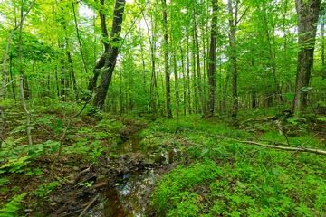
Photo by Josh Mayer
Chequamegon Hardwoods is an old second-growth northern mesic hardwood forest with an undisturbed understory. Scattered throughout the site are several very large exposures of gabbro bedrock, some up to 50 feet in height. Although the stand was logged in the 1930s, it still retains patches of old-growth hemlock, various hardwoods and some very large big-tooth aspen. Sugar maple, basswood, and yellow birch dominate most of the stand with canopy associates with red oak and white ash.
Other areas feature hemlock and large big-tooth aspen. The midstory includes such characteristic species as leather-leaf, mountain maple, beaked hazelnut, and alternate-leaved dogwood. The herbaceous layer has never been grazed and is diverse with over 80 plant species including spikenard, blue cohosh, green adders-mouth, nodding trillium, maidenhair fern, and bloodroot. Three orchids, purple fringed, spotted coral, and early coral root are also present. Low areas of wet-mesic forest are dominated by black ash with white cedar, red maple, yellow birch, and hemlocks with an understory of speckled alder, swamp aster, and spotted Joe-Pye-weed.
The stream running through the site contains a good population of Fontinalis, an aquatic moss, and an abundant larval caddisfly fauna. Numerous forest interior birds are present such as Nashville, black and white, black-throated green warblers, ovenbird, and wood pewee. Chequamegon Hardwoods is owned by the U.S. Forest Service and was designated a State Natural Area in 1996. This site is also recognized by the Forest Service as an established Research Natural Area.
Very few State Natural Areas have public facilities, but nearly all are open for a variety of recreational activities as indicated below. Generally, there are no picnic areas, restrooms, or other developments. Parking lots or designated parking areas are noted on individual SNA pages and maps. If a developed trail is present, it will normally be noted on the SNA map and/or under the Maps tab. A compass and topographic map or a GPS unit are useful tools for exploring larger, isolated SNAs.
The good majority of SNAs are isolated and have few or no facilities. Some SNAs have vehicle access lanes or parking lots, but their accessibility may vary depending on weather conditions. Parking lots and lanes are not plowed during winter. Hiking trails may be nonexistent or consist of undeveloped footpaths. A GPS unit or compass and a detailed topographic map are useful tools for exploring larger SNAs.
Non-DNR lands
Entrance fees: For non-DNR-owned SNAs, we are unaware of any vehicle or admission fees. However, please contact the landowner for more information.
Hunting and trapping
Other activities
Other allowable activities such as - but not limited to camping, geocaching and bicycling are determined by the landowner. Please contact them directly or visit their websites for details.
Location
Within the Chequamegon-Nicolet National Forest, Ashland County. T44N-R3W, Section 6. 74 acres.
Driving directions
From the intersection of State Highway 13 and County Highway GG in Mellen, go southwest on GG for about 8 miles, then northwest on FR 187 (Mineral Lake Road) for 0.7 miles, then north on FR 188 (Hanson Road) 1.6 miles to where the North Country Trail crosses the road. Park along the road and walk due northmiles5 miles to the southern boundary of the site. The North Country Trail just skirts the southeastern tip of the natural area as it heads in a northeasterly direction.
The DNR's state natural areas program is comprised of lands owned by the state, private conservation organizations, municipalities, other governmental agencies, educational institutions and private individuals. While the majority of SNAs are open to the public, access may vary according to individual ownership policies. Public use restrictions may apply due to public safety, or to protect endangered or threatened species or unique natural features. Lands may be temporarily closed due to specific management activities.
Users are encouraged to contact the landowner for more specific details. The data shown on these maps have been obtained from various sources, and are of varying age, reliability, and resolution. The data may contain errors or omissions and should not be interpreted as a legal representation of legal ownership boundaries. To create your custom map where you can zoom to a specific location, please use the DNR's Mapping Application.
Chequamegon Hardwoods is owned by: US Forest Service