Cedarburg Bog
No. 2
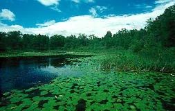
Photo by Thomas A. Meyer/DNR
Cedarburg Bog is the most intact large bog in southeastern Wisconsin and is composed of a mosaic of vegetation types. Once part of a large glacial lake, the bog is a relict community - a southern example of the type more commonly found in northern Wisconsin. Six lakes are remaining within the bog, all with varying sizes and depths. The 245-acre Mud Lake is the largest, followed by the 34-acre Long Lake. Surrounding the lakes are areas of emergent aquatic vegetation while just outside this zone is a successional shrub-carr area.
Most unusual is a string or "patterned" bog, unique here because it lies far south of its usual range in North America. It is composed of ridges of stunted cedar and tamarack that lie in an open flat sedge mat. The meadow vegetation consists of narrow-leaved sedges, pitcher plants, bogbeans, water horsetails, arrowgrass, orchids, and the insectivorous sundew and bladderwort. A conifer-swamp hardwood forest is adjacent to the bog. There is a very diverse flora and fauna; many that are more common in northern boreal forests and that are at their southern range limit here. Cedarburg Bog is owned by the DNR and the University of Wisconsin and was designated a State Natural Area in 1952.
Very few State Natural Areas have public facilities, but nearly all are open for a variety of recreational activities as indicated below. Generally, there are no picnic areas, restrooms, or other developments. Parking lots or designated parking areas are noted on individual SNA pages and maps. If a developed trail is present, it will normally be noted on the SNA map and/or under the Maps tab. A compass and topographic map or a GPS unit are useful tools for exploring larger, isolated SNAs.
The good majority of SNAs are isolated and have few or no facilities. Some SNAs have vehicle access lanes or parking lots, but their accessibility may vary depending on weather conditions. Parking lots and lanes are not plowed during winter. Hiking trails may be nonexistent or consist of undeveloped footpaths. A GPS unit or compass and a detailed topographic map are useful tools for exploring larger SNAs.
Hunting and trapping
Allowable activities: DNR-owned land
The activities listed below are generally allowed on all DNR-owned SNA lands. Exceptions to this list of public uses, such as SNAs closed to hunting, are noted above and posted with signs on the property site.
- Hiking
- Fishing
- Cross country skiing
- Hunting
- Trapping
- Scientific research (permit required [PDF])
- Outdoor education
- Wild edibles (What is this?)
- Pets (Rules)
- Wildlife viewing
Prohibited activities: all SNAs
- Camping and campfires
- Collecting of animals (other than legally harvested species), non-edible fungi, rocks, minerals, fossils, archaeological artifacts, soil, downed wood, or any other natural material, alive or dead.
- Collecting for scientific research requires a permit issued by the DNR
- Collecting of plants including seeds, roots or other non-edible parts of herbaceous plants such as wildflowers or grasses
- Geocaching
- Horseback riding
- Rock climbing
- Vehicles, including bicycles, ATVs, aircraft, and snowmobiles except on trails and roadways designated for their use.
For rules governing state-owned SNAs and other state lands, please consult Chapter NR 45 Wis. Admin. Code [exit DNR].
Location
Ozaukee County. T11N-R21E, Sections 20, 21, 28-33. 1,845 acres.
Driving directions
From the intersection of County Highway Y and State Highway 33 in Newburg, go east on 33 2.6 miles to a parking area on the south side of the road. A trail leads to a pier on Watts Lake. For access to Mud Lake and the heart of the bog, go south on Y 4.2 miles, then east on Cedar-Sauk Road, 0.75 miles to a pull-off on the north side of the road. Walk north along a boggy, unimproved trail to the lake. A kayak or canoe is required to reach the interior. Access to UW-Milwaukee land is available to groups by contacting the UW-Milwaukee Field Station [exit DNR] on Blue Goose Road at (262)675-6844.
The DNR's state natural areas program is comprised of lands owned by the state, private conservation organizations, municipalities, other governmental agencies, educational institutions and private individuals. While the majority of SNAs are open to the public, access may vary according to individual ownership policies. Public use restrictions may apply due to public safety, or to protect endangered or threatened species or unique natural features. Lands may be temporarily closed due to specific management activities.
Users are encouraged to contact the landowner for more specific details. The data shown on these maps have been obtained from various sources, and are of varying age, reliability, and resolution. The data may contain errors or omissions and should not be interpreted as a legal representation of legal ownership boundaries. To create your custom map where you can zoom to a specific location, please use the DNR's Mapping Application.
Cedarburg Bog is owned by: The UW Board of Regents and the Wisconsin DNR
Management objectives and prescriptions
- Read the Northern Kettle Moraine Region Master Plan for details.