Cedar Grove Hawk Research Station
No. 8
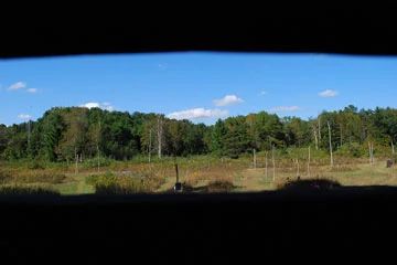
Photo by Josh Mayer
Cedar Grove Hawk Research Station is located on a 1,000-foot-wide beach of the former glacial Lake Algonquin and is intermediate in elevation between the cultivated uplands to the west and Lake Michigan to the east. It has long been known as a site to view spectacular raptor migrations and has been used as a trapping and banding station for more than 60 years, primarily during the fall. Today, it is one of the major banding and observation areas for long-term raptor research.
In the 1940s, the Milwaukee Public Museum banded hawks here. In 1950 Helmut Mueller and Dan Berger began trapping and banding raptors and passerines and they continue their research today. The station has the longest sustained record of activity in North America for trapping and banding migratory raptors and more than 38,000 birds of prey of 24 species have been live-trapped, banded, measured, and released. The following birds were first spotted or banded in Wisconsin at the station: gyrfalcon, Mississippi kite, gray vireo, anhinga, and Harris's hawk. Cedar Grove Hawk Research Station is owned by the DNR and is maintained by the Cedar Grove Ornithological Research Station. It was designated a State Natural Area in 1952.
The primary use of the research station – bird banding, trapping and research – requires as little disturbance from people as possible. Permission for access is needed to avoid conflicts. Please contact the State Natural Areas Program for more information.
Very few State Natural Areas have public facilities, but nearly all are open for a variety of recreational activities as indicated below. Generally, there are no picnic areas, restrooms, or other developments. Parking lots or designated parking areas are noted on individual SNA pages and maps. If a developed trail is present, it will normally be noted on the SNA map and/or under the Maps tab. A compass and topographic map or a GPS unit are useful tools for exploring larger, isolated SNAs.
The good majority of SNAs are isolated and have few or no facilities. Some SNAs have vehicle access lanes or parking lots, but their accessibility may vary depending on weather conditions. Parking lots and lanes are not plowed during winter. Hiking trails may be nonexistent or consist of undeveloped footpaths. A GPS unit or compass and a detailed topographic map are useful tools for exploring larger SNAs.
Entrance fees: Excepting Parfrey's Glen, the Cambrian Outlook in the Dells of the Wisconsin River, SNAs within State Parks and some within State Forests, all other DNR-owned SNAs do not have any admission fees. For more information, see Wis. Admin. Code NR 45 [exit DNR]. For non-DNR-owned SNAs, we are unaware of any vehicle or admission fees. However, please contact the landowner for more information.
Allowable activities: DNR-owned land
The activities listed below are generally allowed on DNR-owned SNA lands. Exceptions to this list of public uses, such as SNAs closed to hunting, are noted on the website and posted with signs on the property.
- Hiking
- Fishing
- Cross country skiing
- Hunting
- Trapping
- Scientific research (permit required [PDF])
- Outdoor education
- Wild edibles (What is this?)
- Pets (Rules)
- Wildlife viewing
Prohibited activities: all SNAs
Although a handful of sites allow activities like primitive camping (e.g. Lower Chippewa River on sand bars) or horseback riding (e.g. S. Kettle Moraine), the activities listed below are generally prohibited on DNR-owned SNAs.
- Camping and campfires
- Collecting of animals (other than legally harvested species), non-edible fungi, rocks, minerals, fossils, archaeological artifacts, soil, downed wood, or any other natural material, alive or dead.
- Collecting for scientific research requires a permit issued by the DNR
- Collecting of plants including seeds, roots or other non-edible parts of herbaceous plants such as wildflowers or grasses
- Drones: Flying-related activities, including the use of drones, hang-gliders and model airplanes, are prohibited. Permission may be issued by the SNA Program for the use of drones for educational or research purposes
- Geocaching
- Horseback riding
- Rock climbing
- Vehicles, including bicycles, ATVs, aircraft, and snowmobiles except on trails and roadways designated for their use.
For rules governing state-owned SNAs and other state lands, please consult Chapter NR 45 Wis. Admin. Code [exit DNR].
Location
Sheboygan County. T13N-R23E, Section 30. 34 acres.
Driving directions
The primary use of the research station – bird banding, trapping, and research – requires as little disturbance from people as possible. Permission for access is needed to avoid conflicts. Please contact the State Natural Areas Program for more information. This area is a year-round game refuge (Ch. NR 15) and no recreational hunting or trapping is allowed.
The DNR's state natural areas program is comprised of lands owned by the state, private conservation organizations, municipalities, other governmental agencies, educational institutions and private individuals. While the majority of SNAs are open to the public, access may vary according to individual ownership policies. Public use restrictions may apply due to public safety, or to protect endangered or threatened species or unique natural features. Lands may be temporarily closed due to specific management activities.
Users are encouraged to contact the landowner for more specific details. The data shown on these maps have been obtained from various sources, and are of varying age, reliability, and resolution. The data may contain errors or omissions and should not be interpreted as a legal representation of legal ownership boundaries. To create your custom map where you can zoom to a specific location, please use the DNR's Mapping Application.
Cedar Grove Hawk Research Station is owned by: Wisconsin DNR