Cave Point-Clay Banks
No. 559
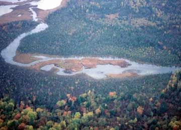
Photo by Wisconsin DNR
Three units, Kellner Fen, Shivering Sands, and Sturgeon Bay comprise the SNA. Located along the Lake Michigan shoreline, Cave Point-Clay Banks is an extensive complex of coastal wetlands that supports many unique plants and animals. Lakeshore, open active dunes, ridge and swale topography, embayment lakes and wetlands, and large tracts of mixed conifer-hardwood forest characterize the area. The embayment lakes and wetlands were formed thousands of years ago along the Door Peninsula coastline when a series of ancient Lake Michigan bays were closed off through sand and cobble deposition from longshore currents. As a result of the deposition, ridges and swales along with calcareous fens and high-quality forested wetlands are found here today.
Kellner Fen is an embayment wetland similar to other near-shore lakes on the Door Peninsula. However, this fen differs since it has no natural outlet to Lake Michigan. Through the natural processes of sand deposition and subsequent dune formation, it was completely isolated from the lake waters until two small, man-made outlets were dug more than 60 years ago. This site features a floating peat mat with a series of interconnected open-water pools at the center and is critical habitat for rare dragonflies. The mat consists of a diversity of sedges, bulrushes, and a rare orchid. Numerous migratory birds use the fen for a stopover and nesting habitat. A lowland conifer/hardwood forest borders the fen to the north while a near-mile-long, 20 to 30-foot-high dune borders the east and south. West of the fen is a second-growth mesic to wet-mesic conifer hardwood forest growing on thin soils over dolomite. The Lake Michigan shore has stretches of sand, pebble, and bedrock shoreline.
The Shivering Sands Unit encompasses many geologic and natural elements to form a contiguous and complex landscape. Large tracts of lowland coniferous forest grade to upland stands of mixed northern hardwood/conifer forest. A complex hydrologic pattern is manifest by numerous springs that emanate from the dolomite bedrock. Small streams thread through the area and both feed and drain the site. Substrates of peat, marl, sand, loam, and dolostone bedrock underlie the mosaic of forest and wetland. Surrounding three undeveloped lakes is an extensive wet-mesic forest of white cedar, tamarack, alder, and balsam fir. Abundant puddles, pools, and ponds saturate the forest. The lakes contain dense expanses of emergent vegetation that provide excellent habitats for nesting waterfowl and wading birds. A large ridge and swale formation supports a forest of white birch, red maple, beech, hemlock, and white pine. To the east, a white pine, hemlock, white spruce, white cedar, and paper birch forest occurs on the rocky uplands and contains many species more commonly found further north. This large contiguous forest supports a unique fauna rarely found elsewhere on the Door Peninsula. An impressive suite of mammals includes fisher, otter, snowshoe hare, porcupine, mink, and coyote. Over 110 species of birds have been documented to breed here.
The Sturgeon Bay Unit contains an extensive ridge and swale landscape that is laterally bisected by the Sturgeon Bay Ship Canal. Built-in the 1870s, the canal connects Lake Michigan with the waters of Green Bay. On either side of the canal is an extensive mosaic of dry-mesic to mesic forested dunes and ridges interspersed with flooded swales. To the west is a lowland conifer forest that occupies an ancient lakebed, which was present when Lake Michigan water levels were higher than today. This landscape is exceptional both regarding its physical extent and in the diversity of natural communities and native species present. The adjacency to Lake Michigan and the north-south coastline orientation make this site critical stopover habitat for numerous bird species.
Cave Point-Clay Banks is owned by the Door County Land Trust, The Wisconsin Chapter of the Nature Conservancy, and DNR with acquisition funding support from the U.S. Fish and Wildlife Service Coastal Wetlands Grant Program. The site was designated a State Natural Area in 2008.
Very few State Natural Areas have public facilities, but nearly all are open for a variety of recreational activities as indicated below. Generally, there are no picnic areas, restrooms, or other developments. Parking lots or designated parking areas are noted on individual SNA pages and maps. If a developed trail is present, it will normally be noted on the SNA map and/or under the Maps tab. A compass and topographic map or a GPS unit are useful tools for exploring larger, isolated SNAs.
The good majority of SNAs are isolated and have few or no facilities. Some SNAs have vehicle access lanes or parking lots, but their accessibility may vary depending on weather conditions. Parking lots and lanes are not plowed during winter. Hiking trails may be nonexistent or consist of undeveloped footpaths. A GPS unit or compass and a detailed topographic map are useful tools for exploring larger SNAs.
Non-DNR lands
Entrance fees: For non-DNR-owned SNAs, we are unaware of any vehicle or admission fees. However, please contact the landowner for more information.
Hunting and trapping
This SNA has multiple landowners: Opportunities for hunting and trapping depend on the landowner. In general, most DNR-owned land allows hunting and trapping. Partner-owned land may have other rules (for example, university-owned lands do not allow hunting or trapping). Please contact them directly to find out about their rules for hunting and trapping. You can find a link to other owner websites under the Resources tab.
The Shivering Sands unit is open to deer hunting. Access from County T south of Whitefish Bay. For hunting opportunities on Nature Conservancy land, visit The Nature Conservancy's Deer Management [exit DNR].
Other activities
Other allowable activities such as - but not limited to camping, geocaching and bicycling are determined by the landowner. Please contact them directly or visit their websites for details.
Location
Door County. T27N-R26E, Section 12. T28N-R27E, Sections 16, 21, 28, 32. 1,617 acres.
Driving directions
For the Sturgeon Bay Ship Canal unit, from Highway 42/57 in Sturgeon Bay, about 0.4 miles south of the Bay View bridge, go south on County U (Clay Banks Road) 2 miles, then go east on Lake Lane 1.5 miles to a parking area on the left side of the road. Or continue another 0.5 miles to another parking area at the junction of S. Lake Michigan Drive. Trails provide access through the site. Local ordinances require hunters interested in hunting at the Sturgeon Bay Ship Canal unit to obtain a written permit from the City of Sturgeon Bay.
The DNR's state natural areas program is comprised of lands owned by the state, private conservation organizations, municipalities, other governmental agencies, educational institutions and private individuals. While the majority of SNAs are open to the public, access may vary according to individual ownership policies. Public use restrictions may apply due to public safety, or to protect endangered or threatened species or unique natural features. Lands may be temporarily closed due to specific management activities.
Users are encouraged to contact the landowner for more specific details. The data shown on these maps have been obtained from various sources, and are of varying age, reliability, and resolution. The data may contain errors or omissions and should not be interpreted as a legal representation of legal ownership boundaries. To create your custom map where you can zoom to a specific location, please use the DNR's Mapping Application.
Cave Point-Clay Banks is owned by: Door County Land Trust and The Nature Conservancy
Management objectives and prescriptions
- Read the Shivering Sands management plan [PDF] for details.