Cassville Bluffs-Roe Unit
No. 337
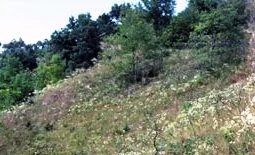
Photo by E. Epstein
Cassville Bluffs features a rare expanse of undeveloped bluff and sand terrace overlooking the Mississippi River that supports linear strips of dry prairie and rare chinquapin oak savanna. Extremely important and unique to this high-quality natural area are the uplands, which remain connected to the river bottoms below and are not separated by any roads or highways. Currently, Wisconsin has only one mile of protected riverfront property that has no highway between the bluffs and the Mississippi River. One of the rarest savanna types in Wisconsin, the chinquapin oak savanna is dominated by chinquapin oak with some bur oak and contains a diverse, intact ground layer.
The dry prairie is also diverse and dominated by side oats grama with little blue-stem, Indian grass, needle grass, big blue-stem, and Panicum grasses. Prairie forbs include flowering spurge, western sunflower, cylindrical blazing star, compass plant, lead plant, and short green milkweed. The site also harbors the uncommon jeweled shooting star and there are scattered dolomite outcroppings several meters high that support numerous fern species including rusty woodsia and smooth cliffbrake. Along the bluff is an older-growth forest that is an important roosting site for bald eagles. The bluffs are also important habitats for rare animals. Numerous agricultural and old fields will be restored to native habitats in the future. Cassville Bluffs is owned jointly by the DNR and the Mississippi Valley Conservancy and was designated a State Natural Area in 2002.
Very few State Natural Areas have public facilities, but nearly all are open for a variety of recreational activities as indicated below. Generally, there are no picnic areas, restrooms, or other developments. Parking lots or designated parking areas are noted on individual SNA pages and maps. If a developed trail is present, it will normally be noted on the SNA map and/or under the Maps tab. A compass and topographic map or a GPS unit are useful tools for exploring larger, isolated SNAs.
The good majority of SNAs are isolated and have few or no facilities. Some SNAs have vehicle access lanes or parking lots, but their accessibility may vary depending on weather conditions. Parking lots and lanes are not plowed during winter. Hiking trails may be nonexistent or consist of undeveloped footpaths. A GPS unit or compass and a detailed topographic map are useful tools for exploring larger SNAs.
Hunting and trapping
Allowable activities: DNR-owned land
The activities listed below are generally allowed on all DNR-owned SNA lands. Exceptions to this list of public uses, such as SNAs closed to hunting, are noted above and posted with signs on the property site.
- Hiking
- Fishing
- Cross country skiing
- Hunting
- Trapping
- Scientific research (permit required [PDF])
- Outdoor education
- Wild edibles (What is this?)
- Pets (Rules)
- Wildlife viewing
Prohibited activities: all SNAs
- Camping and campfires
- Collecting of animals (other than legally harvested species), non-edible fungi, rocks, minerals, fossils, archaeological artifacts, soil, downed wood, or any other natural material, alive or dead.
- Collecting for scientific research requires a permit issued by the DNR
- Collecting of plants including seeds, roots or other non-edible parts of herbaceous plants such as wildflowers or grasses
- Geocaching
- Horseback riding
- Rock climbing
- Vehicles, including bicycles, ATVs, aircraft, and snowmobiles except on trails and roadways designated for their use.
For rules governing state-owned SNAs and other state lands, please consult Chapter NR 45 Wis. Admin. Code [exit DNR].
Location
Grant County. T3N-R5W, Sections 26, 35. 244 acres.
Driving directions
From the intersection of State Highways 81 and 133 in Cassville, go east on 133 for 2.5 miles, then south on Sand Lake Lane for 0.4 miles. Bear left at the end of the lane, go past the house and park at the preserve sign and gate. The best prairie lies on the steep south-facing slopes in the SE portion of the preserve. Walk east on an old access road into the site and then along the southern boundary for one mile. Walk up the steep slope to the prairie.
The DNR's state natural areas program is comprised of lands owned by the state, private conservation organizations, municipalities, other governmental agencies, educational institutions and private individuals. While the majority of SNAs are open to the public, access may vary according to individual ownership policies. Public use restrictions may apply due to public safety, or to protect endangered or threatened species or unique natural features. Lands may be temporarily closed due to specific management activities.
Users are encouraged to contact the landowner for more specific details. The data shown on these maps have been obtained from various sources, and are of varying age, reliability, and resolution. The data may contain errors or omissions and should not be interpreted as a legal representation of legal ownership boundaries. To create your custom map where you can zoom to a specific location, please use the DNR's Mapping Application.
Cassville Bluffs-Roe Unit is owned by: Mississippi Valley Conservancy and Wisconsin DNR
Management objectives and prescriptions
- Read the Cassville Bluffs management plan [PDF] for details.