Caryville Savanna
No. 263
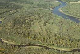
Photo by E. Epstein
Caryville Savanna features extensive and exceptionally high-quality oak barrens situated on Brush Island, a low, sandy island in the Chippewa River. Groves of bur, white, black, and Hill’s oaks are interspersed with prairie grasses and forbs. Characterized by a vegetation gradient from east to west, bur oaks dominate the eastern portion and are scattered among tall grasses such as big blue-stem and Indian grass while black or Hill's oaks are found among the shorter grasses such as little blue-stem and June grass. Among the characteristic forbs are flowering spurge, puccoon, lead plant, white wild indigo, bush clover, spiderwort, dotted mint, ground cherry, white sage, and prairie smoke.
Lichens and sand club moss are dominant in sandy, undisturbed areas. Shrubs are invading the openings with gray dogwood, smooth sumac, and prickly ash forming dense thickets in places. Several small open swales occur along the east edge of the savanna with sedges, rushes, and white meadowsweet as the dominant plants. The low-lying eastern end of the island is wooded with silver maple, green ash, river birch, and hackberry. Typical understory plants include winterberry, eastern wahoo, cut-leaved coneflower, and sedges with stinging nettle and poison ivy abundant in the understory. Caryville Savanna is owned by Dunn County and was designated a State Natural Area in 1991.
Very few State Natural Areas have public facilities, but nearly all are open for a variety of recreational activities as indicated below. Generally, there are no picnic areas, restrooms, or other developments. Parking lots or designated parking areas are noted on individual SNA pages and maps. If a developed trail is present, it will normally be noted on the SNA map and/or under the Maps tab. A compass and topographic map or a GPS unit are useful tools for exploring larger, isolated SNAs.
The good majority of SNAs are isolated and have few or no facilities. Some SNAs have vehicle access lanes or parking lots, but their accessibility may vary depending on weather conditions. Parking lots and lanes are not plowed during winter. Hiking trails may be nonexistent or consist of undeveloped footpaths. A GPS unit or compass and a detailed topographic map are useful tools for exploring larger SNAs.
Non-DNR lands
Entrance fees: For non-DNR-owned SNAs, we are unaware of any vehicle or admission fees. However, please contact the landowner for more information.
Hunting and trapping
Other activities
Other allowable activities such as - but not limited to camping, geocaching and bicycling are determined by the landowner. Please contact them directly or visit their websites for details.
Location
Dunn County. T26N-R11W, Sections 5-9. 412 acres.
Driving directions
By canoe. From the intersection of Highways 85 and H just north of Caryville, go north on H across the Chippewa River 0.5 mile to a boat landing. Canoe downstream approximately 3 miles to Brush Island south of the main channel and north of Meridean Slough. Canoe access is also available from 240th Avenue.
The DNR's state natural areas program is comprised of lands owned by the state, private conservation organizations, municipalities, other governmental agencies, educational institutions and private individuals. While the majority of SNAs are open to the public, access may vary according to individual ownership policies. Public use restrictions may apply due to public safety, or to protect endangered or threatened species or unique natural features. Lands may be temporarily closed due to specific management activities.
Users are encouraged to contact the landowner for more specific details. The data shown on these maps have been obtained from various sources, and are of varying age, reliability, and resolution. The data may contain errors or omissions and should not be interpreted as a legal representation of legal ownership boundaries. To create your custom map where you can zoom to a specific location, please use the DNR's Mapping Application.
Caryville Savanna is owned by: Dunn County