Carver-Roehl Woods
No. 649
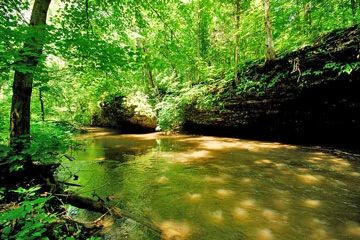
Photo by Josh Mayer
Situated on older ground moraine from an earlier episode of Wisconsinan glaciation, Carver-Roehl Woods features scenic limestone cliffs bordered by southern dry-mesic forest. Carved by Spring Brook Creek, a small tributary to Turtle Creek that runs the length of the park, the shaded cliffs support bulblet fern, cliffbrake, clearweed, and Virginia creeper. Along the gently sloping stream bank and bottoms is a mesic forest dominated by large, mature bur oak, white oak, and black cherry with red oak, basswood, sugar maple, scattered black willow, and green ash.
A diverse flora is found here – particularly where volunteers have worked to eradicate the non-native invasive garlic mustard. Plants include skunk cabbage, wild leek, Jack-in-the-pulpit, wild ginger, blue cohosh, red fescue, and bloodroot. The upper woods are situated on rolling hills with mostly red, white, and bur oak with cherry, ironwood, sugar maple, and hope hornbeam. The ground flora is comprised of many native species typical to savannas including sharp-lobed hepatica, Robin's plantain, wood betony, smooth rock cress, shooting star, woodland phlox, and rattlesnake-root. Carver-Roehl Woods is owned by Rock County and was designated a State Natural Area in 2011.
Very few State Natural Areas have public facilities, but nearly all are open for a variety of recreational activities as indicated below. Generally, there are no picnic areas, restrooms, or other developments. Parking lots or designated parking areas are noted on individual SNA pages and maps. If a developed trail is present, it will normally be noted on the SNA map and/or under the Maps tab. A compass and topographic map or a GPS unit are useful tools for exploring larger, isolated SNAs.
The good majority of SNAs are isolated and have few or no facilities. Some SNAs have vehicle access lanes or parking lots, but their accessibility may vary depending on weather conditions. Parking lots and lanes are not plowed during winter. Hiking trails may be nonexistent or consist of undeveloped footpaths. A GPS unit or compass and a detailed topographic map are useful tools for exploring larger SNAs.
Non-DNR lands
Entrance fees: For non-DNR-owned SNAs, we are unaware of any vehicle or admission fees. However, please contact the landowner for more information.
Hunting and trapping
Other activities
Other allowable activities such as - but not limited to camping, geocaching and bicycling are determined by the landowner. Please contact them directly or visit their websites for details.
Location
Located within Carver-Roehl County Park [exit DNR], Rock County. T2N-R14E, Section 27. 26 acres.
Driving directions
From the intersection of Avalon Road and Highway 140 just east of Avalon, go south on 140 for 1.5 miles, then east on E. Larsen Road for 1.7 miles, then south 0.3 miles on Carver’s Rock Road to the park entrance.
The DNR's state natural areas program is comprised of lands owned by the state, private conservation organizations, municipalities, other governmental agencies, educational institutions and private individuals. While the majority of SNAs are open to the public, access may vary according to individual ownership policies. Public use restrictions may apply due to public safety, or to protect endangered or threatened species or unique natural features. Lands may be temporarily closed due to specific management activities.
Users are encouraged to contact the landowner for more specific details. The data shown on these maps have been obtained from various sources, and are of varying age, reliability, and resolution. The data may contain errors or omissions and should not be interpreted as a legal representation of legal ownership boundaries. To create your custom map where you can zoom to a specific location, please use the DNR's Mapping Application.
Carver-Roehl Woods is owned by: Rock County