Caroline Lake
No. 336
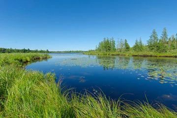
Photo by Josh Mayer
Caroline Lake is an undeveloped soft-water drainage lake and the headwaters of the Bad River, which eventually replenishes the water of the National Natural Landmark, Kakagon/Bad River Sloughs. While important primarily for its position at the headwaters of the Bad River, the lake is surrounded by numerous high-quality plant communities including northern wet forest, northern dry-mesic forest, northern sedge meadow, shrub carr, and open bog. Lakeshore vegetation is predominantly upland hardwoods with a mixed conifer, hardwood and tag alder swamp near the Bad River outlet and along the northeast shore on an intermittent feeder stream.
A narrow zone of macrophytes occupies a 1 to 15-meter-wide strip along much of the shoreline. Representative species are hard-stem bulrush, river horsetail, water-shield, bull-head pond-lily, white water-lily, ribbon-leaf pondweed, and coon's-tail. Freshwater sponges have been observed near the outlet on submerged woody debris. The nearby Twin Lakes-East is a soft-water seepage lake with a short, navigable stream channel connecting to Twin Lakes-West. Bog vegetation surrounds Twin Lakes-East on its west and eastern shores.
Upland hardwoods and conifers are also present. Twin Lakes-West is an acid bog lake with an outlet flow to the northwest of Eureka Lake. Black spruce, tamarack, birch, red maple, and white pine surround the lake. Upland areas contain scattered red and white pine. The extensive forested wetlands of this site are an important nesting area for several warbler species. Common loons, osprey, and bald eagles have been observed at the site. Caroline Lake is owned by The Wisconsin Chapter of the Nature Conservancy and the DNR. It was designated a State Natural Area in 2002.
Very few State Natural Areas have public facilities, but nearly all are open for a variety of recreational activities as indicated below. Generally, there are no picnic areas, restrooms, or other developments. Parking lots or designated parking areas are noted on individual SNA pages and maps. If a developed trail is present, it will normally be noted on the SNA map and/or under the Maps tab. A compass and topographic map or a GPS unit are useful tools for exploring larger, isolated SNAs.
The good majority of SNAs are isolated and have few or no facilities. Some SNAs have vehicle access lanes or parking lots, but their accessibility may vary depending on weather conditions. Parking lots and lanes are not plowed during winter. Hiking trails may be nonexistent or consist of undeveloped footpaths. A GPS unit or compass and a detailed topographic map are useful tools for exploring larger SNAs.
Hunting and trapping
For hunting opportunities on Nature Conservancy land, visit The Nature Conservancy's Deer Management [exit DNR].
Allowable activities: DNR-owned land
The activities listed below are generally allowed on all DNR-owned SNA lands. Exceptions to this list of public uses, such as SNAs closed to hunting, are noted above and posted with signs on the property site.
- Hiking
- Fishing
- Cross country skiing
- Hunting
- Trapping
- Scientific research (permit required [PDF])
- Outdoor education
- Wild edibles (What is this?)
- Pets (Rules)
- Wildlife viewing
Prohibited activities: all SNAs
- Camping and campfires
- Collecting of animals (other than legally harvested species), non-edible fungi, rocks, minerals, fossils, archaeological artifacts, soil, downed wood, or any other natural material, alive or dead.
- Collecting for scientific research requires a permit issued by the DNR
- Collecting of plants including seeds, roots or other non-edible parts of herbaceous plants such as wildflowers or grasses
- Geocaching
- Horseback riding
- Rock climbing
- Vehicles, including bicycles, ATVs, aircraft, and snowmobiles except on trails and roadways designated for their use.
For rules governing state-owned SNAs and other state lands, please consult Chapter NR 45 Wis. Admin. Code [exit DNR].
Location
Ashland and Iron Counties. T44N-R1W, Section 19. T44N-R2W, Sections 13, 23, 24, 25. 458 acres.
Driving directions
From the intersection of State Highways 13 and 77 in Mellen, go east on 77 for 4.1 miles, then south on County MM (Lake Drive) for 2.3 miles, then east on Caroline Lake Road for 1.6 miles, then continue southeast on Lake Caroline Road about 1 mile to the lake access.
The DNR's state natural areas program is comprised of lands owned by the state, private conservation organizations, municipalities, other governmental agencies, educational institutions and private individuals. While the majority of SNAs are open to the public, access may vary according to individual ownership policies. Public use restrictions may apply due to public safety, or to protect endangered or threatened species or unique natural features. Lands may be temporarily closed due to specific management activities.
Users are encouraged to contact the landowner for more specific details. The data shown on these maps have been obtained from various sources, and are of varying age, reliability, and resolution. The data may contain errors or omissions and should not be interpreted as a legal representation of legal ownership boundaries. To create your custom map where you can zoom to a specific location, please use the DNR's Mapping Application.
Caroline Lake is owned by: The Nature Conservancy and the Wisconsin DNR