Canoe Landing Prairie
No. 526
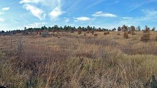
Photo by Aaron Carlson
Situated on gently rolling to flat sandy uplands near the Eau Claire River, Canoe Landing Prairie supports diverse oak barrens and prairie communities of variable composition and structure. Hill's oak is the dominant tree with red pine occasionally present. Hill's/black, white, and bur oak are present as grub trees. A rich prairie understory is present in places while others tend to be dominated by heath-like species such as American hazelnut, early low blueberry, and sweet-fern. Big bluestem, little bluestem, side-oats grama, and prairie brome are grasses found in the prairie understory.
Prairie forbs include butterfly milkweed, short green milkweed, sky blue aster, prairie coreopsis, flowering spurge, blue toadflax, hoary puccoon, goat's-rue, Missouri goldenrod, arrow-leaved violet, and bird's-foot violet. The site also contains wild lupine, which provides the necessary food source for the federally-endangered Karner blue butterfly (Lycaeides melissa samuelis) caterpillar. The Karner blue is restricted to habitats that contain wild lupine, a beautiful purplish-blue flowering plant that is the caterpillar's only food plant. Canoe Landing Prairie is owned by Eau Claire County and was designated a State Natural Area in 2006.
Very few State Natural Areas have public facilities, but nearly all are open for a variety of recreational activities as indicated below. Generally, there are no picnic areas, restrooms, or other developments. Parking lots or designated parking areas are noted on individual SNA pages and maps. If a developed trail is present, it will normally be noted on the SNA map and/or under the Maps tab. A compass and topographic map or a GPS unit are useful tools for exploring larger, isolated SNAs.
The good majority of SNAs are isolated and have few or no facilities. Some SNAs have vehicle access lanes or parking lots, but their accessibility may vary depending on weather conditions. Parking lots and lanes are not plowed during winter. Hiking trails may be nonexistent or consist of undeveloped footpaths. A GPS unit or compass and a detailed topographic map are useful tools for exploring larger SNAs.
Non-DNR lands
Entrance fees: For non-DNR-owned SNAs, we are unaware of any vehicle or admission fees. However, please contact the landowner for more information.
Hunting and trapping
Other activities
Other allowable activities such as - but not limited to camping, geocaching and bicycling are determined by the landowner. Please contact them directly or visit their websites for details.
Location
Within the Eau Claire County Forest. T26N-R5W, Sections 15, 16. 44 acres.
Driving directions
From the intersection of Highway 12 and County G in Augusta, go north and east on G for 7.6 miles, then east on Channey Road for 3.7 miles, then south on Canoe Landing Forest Road for 0.6 miles. The site lies east and west of the road.
The DNR's state natural areas program is comprised of lands owned by the state, private conservation organizations, municipalities, other governmental agencies, educational institutions and private individuals. While the majority of SNAs are open to the public, access may vary according to individual ownership policies. Public use restrictions may apply due to public safety, or to protect endangered or threatened species or unique natural features. Lands may be temporarily closed due to specific management activities.
Users are encouraged to contact the landowner for more specific details. The data shown on these maps have been obtained from various sources, and are of varying age, reliability, and resolution. The data may contain errors or omissions and should not be interpreted as a legal representation of legal ownership boundaries. To create your custom map where you can zoom to a specific location, please use the DNR's Mapping Application.
Canoe Landing Prairie is owned by: Eau Claire County