Camp Three Lake
No. 450
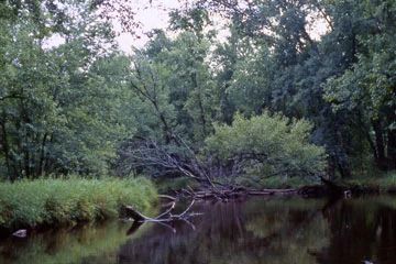
Photo by Ian Shackleford, U.S. Forest Service
Camp Three Lake features a unique silver maple floodplain forest along a meandering portion of the Peshtigo River, a 40-mile-long tributary to Green Bay. Other natural communities present are the northern mesic, wet-mesic, and wet forest. The floodplain forest is dominated by large, unbranched silver maple (up to 28 inches in diameter) with a characteristic floodplain understory including poison ivy, calico aster, Virginia wild-rye, gray-headed coneflower, blue skullcap, sensitive fern, and stinging nettle.
The ground cover is often thick with grasses and sedges. Exposed drying mud with almost no vegetation, both with and without canopy cover, is frequently found. As one moves away from the river, the silver maple is replaced by black ash. The northern mesic forest contains an overstory of sugar maple, basswood, hemlock, and yellow birch. Other trees include paper birch, red maple, and balsam fir. Groundlayer species include northern tree club moss, wild red raspberry, large-leaved aster, tall blue lettuce, and Pennsylvania sedge. White cedar, black spruce, and tamarack dominate the wet-mesic forest; black spruce and tamarack are common in the northern wet forest canopy. Understory species include velvet-leaf blueberry, creeping snowberry, bunchberry, and yellow blue bead lily.
Camp Three Lake is a deep, soft-water lake surrounded by open bog, hemlock slopes, hardwood forests, and white pine. The lake has sparse aquatic vegetation, although an emergent aquatic community occurs to the north. Two creeks draining into the Peshtigo River are included within the site. Haymeadow Creek features an abundant northern sedge meadow community with some alder thicket. Whiting Creek passes through a mixed conifer swamp before joining the Peshtigo. Breeding bird species include pileated woodpecker, least flycatcher, blue-headed vireo, winter wren, scarlet tanager, cape may, mourning, magnolia, and black-throated blue warblers. Camp 3 Lake is owned by the US Forest Service and was designated a State Natural Area in 2007.
Very few State Natural Areas have public facilities, but nearly all are open for a variety of recreational activities as indicated below. Generally, there are no picnic areas, restrooms, or other developments. Parking lots or designated parking areas are noted on individual SNA pages and maps. If a developed trail is present, it will normally be noted on the SNA map and/or under the Maps tab. A compass and topographic map or a GPS unit are useful tools for exploring larger, isolated SNAs.
The good majority of SNAs are isolated and have few or no facilities. Some SNAs have vehicle access lanes or parking lots, but their accessibility may vary depending on weather conditions. Parking lots and lanes are not plowed during winter. Hiking trails may be nonexistent or consist of undeveloped footpaths. A GPS unit or compass and a detailed topographic map are useful tools for exploring larger SNAs.
Non-DNR lands
Entrance fees: For non-DNR-owned SNAs, we are unaware of any vehicle or admission fees. However, please contact the landowner for more information.
Hunting and trapping
Other activities
Other allowable activities such as - but not limited to camping, geocaching and bicycling are determined by the landowner. Please contact them directly or visit their websites for details.
Location
Within the Chequamegon-Nicolet National Forest. Forest County. T36N-R15E, Sections 2, 3, 4, 10, 11. 1,214 acres.
Driving directions
The site can be accessed from Highway 8 and Forest Road 2131, 2132, and 2128. From the intersection of Highways 8 and 32 in Laona, go north on 8 for 3.4 miles, then east on FR 2131 (Peshtigo River Road) for about 4.4 miles to canoe access and the Peshtigo River. The site lies northwest of the road.
The DNR's state natural areas program is comprised of lands owned by the state, private conservation organizations, municipalities, other governmental agencies, educational institutions and private individuals. While the majority of SNAs are open to the public, access may vary according to individual ownership policies. Public use restrictions may apply due to public safety, or to protect endangered or threatened species or unique natural features. Lands may be temporarily closed due to specific management activities.
Users are encouraged to contact the landowner for more specific details. The data shown on these maps have been obtained from various sources, and are of varying age, reliability, and resolution. The data may contain errors or omissions and should not be interpreted as a legal representation of legal ownership boundaries. To create your custom map where you can zoom to a specific location, please use the DNR's Mapping Application.
Camp 3 Lake is owned by: US Forest Service