Camp Nine Pines
No. 470
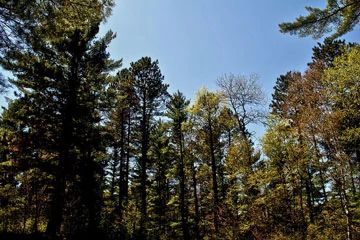 Photo by Aaron Carlson
Camp Nine Pines contains one of the largest blocks of natural red pine and white pine in the Chequamegon-Nicolet National Forest. Other significant attributes include scattered frost pocket barrens, the opportunity to establish a connective corridor to the Rainbow Lake Wilderness Area, and the diversity of forest interior wood warblers. After the initial harvest followed by intense fires on the cutover land, the pine forest was allowed to re-develop and continue towards old-growth until the harvest was again initiated on some portions of the site.
A contiguous canopy of 75 to 100-year-old pine and oak stretches over nearly 3,000 acres in total. The canopy is broken up only by natural open frost pockets and several recent clear-cuts. The forest is dominated by red pine and white pine with significant stands of red oak and jack pine. Associated species are paper birch, quaking aspen, and sugar maple. Red maple is ubiquitous in small numbers throughout the area.
Shrubs include beaked hazelnut, American hazelnut, and American fly honeysuckle. The herbaceous layer includes wood anemone, red baneberry, cinnamon fern, rough-leaved rice grass, round-lobed hepatica, and blunt-leaf orchid. Significant open or partially forested areas are dominated by widely spaced jack pine, bracken fern, and early low blueberry. Common understory species are harebell, smooth aster, big bluestem, and poverty oats. Typically these openings are located in depressions and maintained by frost.
Although recent activity has modified portions of the area, most exhibit the full range of local soil, topographic, and aspect variability. This area represents the best opportunity in the Forest and perhaps in Wisconsin to protect and restore a large block of future old-growth pine. Many rare and uncommon species are found here. Camp Nine Pines is owned by the U.S. Forest Service and was designated a State Natural Area in 2007. This site is also recognized by the Forest Service as an established Research Natural Area.
Very few State Natural Areas have public facilities, but nearly all are open for a variety of recreational activities as indicated below. Generally, there are no picnic areas, restrooms, or other developments. Parking lots or designated parking areas are noted on individual SNA pages and maps. If a developed trail is present, it will normally be noted on the SNA map and/or under the Maps tab. A compass and topographic map or a GPS unit are useful tools for exploring larger, isolated SNAs.
The good majority of SNAs are isolated and have few or no facilities. Some SNAs have vehicle access lanes or parking lots, but their accessibility may vary depending on weather conditions. Parking lots and lanes are not plowed during winter. Hiking trails may be nonexistent or consist of undeveloped footpaths. A GPS unit or compass and a detailed topographic map are useful tools for exploring larger SNAs.
Non-DNR lands
Entrance fees: For non-DNR-owned SNAs, we are unaware of any vehicle or admission fees. However, please contact the landowner for more information.
Hunting and trapping
Other activities
Other allowable activities such as - but not limited to camping, geocaching and bicycling are determined by the landowner. Please contact them directly or visit their websites for details.
Location
Within the Chequamegon-Nicolet National Forest. Bayfield County. T45N-R8W, Section 3. T46N-R8W, Sections 28, 32, 33, 34. 2,958 acres.
Driving directions
From Drummond, go west on County Highway N for 6 miles, then north of FR 229 (Beck Road) for about 5.5 miles to the Camba Bike Trail Trailhead. Trails provide access east and west into the site. Access from the north is provided by W. Delta Lake Road and Beck Road (FR 229).
The DNR's state natural areas program is comprised of lands owned by the state, private conservation organizations, municipalities, other governmental agencies, educational institutions and private individuals. While the majority of SNAs are open to the public, access may vary according to individual ownership policies. Public use restrictions may apply due to public safety, or to protect endangered or threatened species or unique natural features. Lands may be temporarily closed due to specific management activities.
Users are encouraged to contact the landowner for more specific details. The data shown on these maps have been obtained from various sources, and are of varying age, reliability, and resolution. The data may contain errors or omissions and should not be interpreted as a legal representation of legal ownership boundaries. To create your custom map where you can zoom to a specific location, please use the DNR's Mapping Application.
Camp Nine Pines is owned by: US Forest Service