Camp Lake & Pines
No. 506
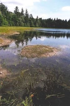
Photo by Thomas A. Meyer/DNR
Camp Lake and Pines feature a dry-mesic forest bordering the east and south sides of Camp Lake, an undisturbed soft-water seepage lake. The canopy is dominated by large red pine and white pine with red oak, red maple, paper birch, balsam fir, big-tooth aspen, and white spruce.
The tall shrub layer is composed primarily of beaked hazelnut. Low shrubs and herbs are wintergreens, Canada mayflower, American starflower, early low blueberry, velvet-leaf blueberry, trailing arbutus, and pipsissewa. The forest, although small in extent, is mature and shows little evidence of recent disturbance.
Old-growth structural characteristics are beginning to appear. The 37-acre Camp Lake has extremely soft, clear water and a sand and gravel bottom. The flora includes several plants that are adapted to the highly oligotrophic (infertile) conditions and can absorb CO2 from the sediment through their roots. This rare plant group, called "sterile rosette flora", are small stiff-leaved plants that hug the lake bottom and are indicative of the lake's soft-water conditions.
Plants include water lobelia, seven-angle pipewort, small waterwort, slender water-milfoil, brown-fruited rush, and golden pert. Other plants of note are hidden-fruited bladderwort, northeastern bladderwort, and clustered beak-rush. Birds using the lake include the American black duck, bald eagle, and common loon. Other birds are the blackburnian warbler, pine warbler, pileated woodpecker, and ovenbird. Camp Lake and Pines is owned by the DNR and was designated a State Natural Area in 2007.
Very few State Natural Areas have public facilities, but nearly all are open for a variety of recreational activities as indicated below. Generally, there are no picnic areas, restrooms, or other developments. Parking lots or designated parking areas are noted on individual SNA pages and maps. If a developed trail is present, it will normally be noted on the SNA map and/or under the Maps tab. A compass and topographic map or a GPS unit are useful tools for exploring larger, isolated SNAs.
The good majority of SNAs are isolated and have few or no facilities. Some SNAs have vehicle access lanes or parking lots, but their accessibility may vary depending on weather conditions. Parking lots and lanes are not plowed during winter. Hiking trails may be nonexistent or consist of undeveloped footpaths. A GPS unit or compass and a detailed topographic map are useful tools for exploring larger SNAs.
Entrance fees: Excepting Parfrey's Glen, the Cambrian Outlook in the Dells of the Wisconsin River, SNAs within State Parks and some within State Forests, all other DNR-owned SNAs do not have any admission fees. For more information, see Wis. Admin. Code NR 45. [exit DNR] For non-DNR-owned SNAs, we are unaware of any vehicle or admission fees. However, please contact the landowner for more information.
Allowable activities: DNR-owned land
The activities listed below are generally allowed on all DNR-owned SNA lands. Exceptions to this list of public uses, such as SNAs closed to hunting, are noted above and posted with signs on the property site.
- Hiking
- Fishing
- Cross country skiing
- Hunting
- Trapping
- Scientific research (permit required [PDF])
- Outdoor education
- Wild edibles (What is this?)
- Pets (Rules)
- Wildlife viewing
Prohibited activities: all SNAs
Although a handful of sites allow activities like primitive camping (e.g. Lower Chippewa River on sand bars) or horseback riding (e.g. S. Kettle Moraine), the activities listed below are generally prohibited on DNR-owned SNAs.
- Camping and campfires
- Collecting of animals (other than legally harvested species), non-edible fungi, rocks, minerals, fossils, archaeological artifacts, soil, downed wood, or any other natural material, alive or dead.
- Collecting for scientific research requires a permit issued by the DNR
- Collecting of plants including seeds, roots or other non-edible parts of herbaceous plants such as wildflowers or grasses
- Drones: Flying-related activities, including the use of drones, hang-gliders and model airplanes, are prohibited. Permission may be issued by the SNA Program for the use of drones for educational or research purposes
- Geocaching
- Horseback riding
- Rock climbing
- Vehicles, including bicycles, ATVs, aircraft, and snowmobiles except on trails and roadways designated for their use.
For rules governing state-owned SNAs and other state lands, please consult Chapter NR 45 Wis. Admin. Code [exit DNR].
Location
Within the Northern Highland-American Legion State Forest, Vilas County. T41N-R6E, Sections 26, 27, 34. 243 acres.
Driving directions
From the junction of County M and Highway 51 (ca. 6 miles north of Woodruff), go north on 51 for nearly one mile, then west on Woods Road 1.9 miles to the north end of Camp Lake.
The DNR's state natural areas program is comprised of lands owned by the state, private conservation organizations, municipalities, other governmental agencies, educational institutions and private individuals. While the majority of SNAs are open to the public, access may vary according to individual ownership policies. Public use restrictions may apply due to public safety, or to protect endangered or threatened species or unique natural features. Lands may be temporarily closed due to specific management activities.
Users are encouraged to contact the landowner for more specific details. The data shown on these maps have been obtained from various sources, and are of varying age, reliability, and resolution. The data may contain errors or omissions and should not be interpreted as a legal representation of legal ownership boundaries. To create your custom map where you can zoom to a specific location, please use the DNR's Mapping Application.
Camp Lake and Pines is owned by: Wisconsin DNR