Camp Five Lake
No. 495
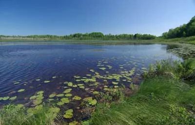 Photo by Thomas A. Meyer/DNR
Camp Five Lake features a diversity of natural community types including a high-quality northern wet-mesic forest dominated by white cedar. Numerous wetlands associated with Camp Five Lake and the First South Branch of the Oconto River are also present. The extensive cedar swamps support rare plant species including dragon's-mouth and Carex tenuiflora growing on a sphagnum mat.
Black spruce and tamarack dominated the northern wet forest. There is an unusual riparian corridor that contains northern sedge meadows and floating mat banks. The shallow, hard, drainage lake contains emergent aquatic plant beds, and groves of dead, flooded conifers. Hemlock increases in abundance near the cedar swamps. The hallmark of this complex is its remote nature and several under-represented wetland communities. Camp Five Lake is owned by the US Forest Service and was designated a State Natural Area in 2007.
Very few State Natural Areas have public facilities, but nearly all are open for a variety of recreational activities as indicated below. Generally, there are no picnic areas, restrooms, or other developments. Parking lots or designated parking areas are noted on individual SNA pages and maps. If a developed trail is present, it will normally be noted on the SNA map and/or under the Maps tab. A compass and topographic map or a GPS unit are useful tools for exploring larger, isolated SNAs.
The good majority of SNAs are isolated and have few or no facilities. Some SNAs have vehicle access lanes or parking lots, but their accessibility may vary depending on weather conditions. Parking lots and lanes are not plowed during winter. Hiking trails may be nonexistent or consist of undeveloped footpaths. A GPS unit or compass and a detailed topographic map are useful tools for exploring larger SNAs.
Non-DNR lands
Entrance fees: For non-DNR-owned SNAs, we are unaware of any vehicle or admission fees. However, please contact the landowner for more information.
Hunting and trapping
Other activities
Other allowable activities such as - but not limited to camping, geocaching and bicycling are determined by the landowner. Please contact them directly or visit their websites for details.
Location
Within the Chequamegon-Nicolet National Forest. Oconto County. T32N-R16E, Sections 9, 16. 69 acres.
Driving directions
From the intersection of County Highway F and State Highway 32 in Lakewood, go south on 32 nearly 3 miles to the First South Branch of the Oconto River. The site lies east of the highway.
The DNR's state natural areas program is comprised of lands owned by the state, private conservation organizations, municipalities, other governmental agencies, educational institutions and private individuals. While the majority of SNAs are open to the public, access may vary according to individual ownership policies. Public use restrictions may apply due to public safety, or to protect endangered or threatened species or unique natural features. Lands may be temporarily closed due to specific management activities.
Users are encouraged to contact the landowner for more specific details. The data shown on these maps have been obtained from various sources, and are of varying age, reliability, and resolution. The data may contain errors or omissions and should not be interpreted as a legal representation of legal ownership boundaries. To create your custom map where you can zoom to a specific location, please use the DNR's Mapping Application.
Camp Five Lake is owned by: US Forest Service