Buffalo River Trail Prairies
No. 358
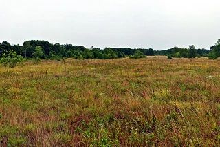
Photo by Aaron Carlson
Buffalo River Trail Prairies contains four high-quality remnants located along the Buffalo River State Recreation Trail. Once an old railroad right-of-way near the meandering Buffalo River, the trail now harbors diverse stretches of prairie that were historically maintained by the unintentional fires sparked by passing railcars.
The four prairie remnants stretch between Eleva and Osseo. One is located west of Eleva, two east of Strum and the largest --a five-mile stretch east of Osseo. The prairies contain numerous species of grasses including big and little bluestem and Indian grass. Showy forbs include stiff goldenrod, prairie coreopsis, spiderwort, and flowering spurge. Buffalo River Trail Prairies is owned by the DNR and was designated a State Natural Area in 2002.
Very few State Natural Areas have public facilities, but nearly all are open for a variety of recreational activities as indicated below. Generally, there are no picnic areas, restrooms, or other developments. Parking lots or designated parking areas are noted on individual SNA pages and maps. Trails, if present, are typically undesignated footpaths. If a developed trail is present, it will normally be noted on the SNA map under the Maps tab. A compass and topographic map or a GPS unit are useful tools for exploring larger, isolated SNAs.
The good majority of SNAs are isolated and have few or no facilities. Some SNAs have vehicle access lanes or parking lots, but their accessibility may vary depending on weather conditions. Parking lots and lanes are not plowed during winter. Hiking trails may be nonexistent or consist of undeveloped footpaths. A GPS unit or compass and a detailed topographic map are useful tools for exploring larger SNAs.
Entrance fees: Except for Parfrey's Glen, the Cambrian Outlook in the Dells of the Wisconsin River, SNAs within State Parks and some within State Forests, all other DNR-owned SNAs do not have any admission fees. For more information, see Wis. Admin. Code NR 45. For non-DNR-owned SNAs, we are unaware of any vehicle or admission fees. However, please contact the landowner for more information.
Allowable activities: DNR-owned land
The activities listed below are generally allowed on all DNR-owned SNA lands. Exceptions to this list of public uses, such as SNAs closed to hunting, are noted above and posted with signs on the property site.
- Hiking
- Fishing
- Cross country skiing
- Hunting
- Trapping
- Scientific research (permit required)
- Outdoor education
- Wild edibles (What is this?)
- Pets (Rules)
- Wildlife viewing
Prohibited activities: all SNAs
- Camping and campfires
- Collecting of animals (other than legally harvested species), non-edible fungi, rocks, minerals, fossils, archaeological artifacts, soil, downed wood, or any other natural material alive or dead.
- Collecting for scientific research requires a permit issued by the DNR
- Collecting of plants including seeds, roots or other non-edible parts of herbaceous plants such as wildflowers or grasses
- Geocaching
- Horseback riding
- Rock climbing
- Vehicles, including bicycles, ATVs, aircraft, and snowmobiles except on trails and roadways designated for their use.
For rules governing state-owned SNAs and other state lands, please consult Chapter NR 45 Wis. Admin. Code [exit DNR].
Location
Jackson and Trempealeau County. T24N-R6W, Sections 5, 6. T24N-R7W, Sections 1, 2. T24N-R8W, Sections 15, 16, and 17. T24N-R9W, Section 7. T24N-R10W, Section 12. 153 acres.
Driving directions
From the junction of I-94 and Highway 10 in Osseo, go east on 10 3.9 miles to a parking area on the north side of the highway. The largest section of prairie runs about 3 miles west and 2 miles east of the parking area. The other three natural area remnants are all accessible via the recreational trail.
The DNR's state natural areas program is comprised of lands owned by the state, private conservation organizations, municipalities, other governmental agencies, educational institutions, and private individuals. While the majority of SNAs are open to the public, access may vary according to individual ownership policies. Public use restrictions may apply due to public safety, or to protect endangered or threatened species or unique natural features. Lands may be temporarily closed due to specific management activities.
Users are encouraged to contact the landowner for more specific details. The data shown on these maps have been obtained from various sources, and are of varying age, reliability, and resolution. The data may contain errors or omissions and should not be interpreted as a legal representation of legal ownership boundaries. To create your custom map where you can zoom to a specific location, please use the DNR's Mapping Application.
Property map [PDF] Property map 2 [PDF] Property map 3 [PDF]
Buffalo River Trail Prairies is owned by: Wisconsin DNR