Brush Creek Hemlocks
No. 466
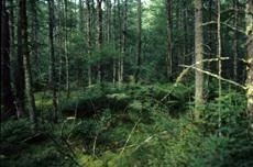
Photo by The U.S. Forest Service
Brush Creek Hemlocks centers around a good quality northern mesic forest of second-growth hemlock-hardwood forest containing an exceptional super-canopy white pine component on rugged terminal moraine topography. Punctuated throughout the area are numerous forested stands of mixed conifer and hardwood swamps in kettle depressions and along riparian drainages. Hemlock, yellow birch, and sugar maple are the canopy dominants with red maple, basswood, and paper birch common. Other associates include red oak, white ash, black cherry, and bitternut hickory.
Tree sizes range up to 24 inches in diameter for hemlock and hardwoods and at least 32 inches for white pine. Although the forest is second-growth, the frequent snags, den trees, coarse woody debris, and small canopy gaps contribute to a developing old-growth structure. One of the largest den trees is a very large yellow birch, about 36 inches in diameter, which may be one of the largest yellow birches in the Park Falls-Medford Ranger District.
The understory is generally open, though yellow birch and sugar maple saplings are common and ironwood and eastern hop-hornbeam are frequent. Also included is a forested reach of Brush Creek, a headwater, morainal stream with rocky, cascading segments alternating with black ash bottoms. The site borders a large ice-walled lake plain to the south, which collapses down into Brush Creek creating a steep-sided ravine. A small, but well-preserved ice-walled lake plain also occurs within the site boundary toward the eastern boundary. To the east is a semi-open tamarack and black spruce bog containing a diverse mix of species including pitcher plant, arrow-grass, royal fern, and moccasin flower.
Other notable species include dwarf scouring rush (Equisetum scirpoides) and lungwort (Lobaria pulmonaria). Brush Creek Hemlocks is owned by the U.S. Forest Service and was designated a State Natural Area in 2007. This site is also recognized by the Forest Service as an established Research Natural Area.
Very few State Natural Areas have public facilities, but nearly all are open for a variety of recreational activities as indicated below. Generally, there are no picnic areas, restrooms, or other developments. Parking lots or designated parking areas are noted on individual SNA pages and maps. Trails, if present, are typically undesignated footpaths. If a developed trail is present, it will normally be noted on the SNA map located under the Map tab. A compass and topographic map or a GPS unit are useful tools for exploring larger, isolated SNAs.
The good majority of SNAs are isolated and have few or no facilities. Some SNAs have vehicle access lanes or parking lots, but their accessibility may vary depending on weather conditions. Parking lots and lanes are not plowed during winter. Hiking trails may be nonexistent or consist of undeveloped footpaths. A GPS unit or compass and a detailed topographic map are useful tools for exploring larger SNAs.
Non-DNR lands
Entrance fees: For non-DNR-owned SNAs, we are unaware of any vehicle or admission fees. However, please contact the landowner for more information.
Hunting and trapping
Other activities
Other allowable activities such as - but not limited to camping, geocaching and bicycling are determined by the landowner. Please contact them directly or visit their websites for details.
Location
Within the Chequamegon-Nicolet National Forest. Taylor County. T32N-R2W, Sections 29, 30. 283 acres.
Driving directions
From the intersection of Hwy M and Hwy 73 go east on M for 4.75 miles, then south on FR 1417 for 1.75 miles to the intersection of FR 1420. Go northeast about 0.5 miles on FR 1420. The site is located on both sides of the road.
The DNR's state natural areas program is comprised of lands owned by the state, private conservation organizations, municipalities, other governmental agencies, educational institutions, and private individuals. While the majority of SNAs are open to the public, access may vary according to individual ownership policies. Public use restrictions may apply due to public safety, or to protect endangered or threatened species or unique natural features. Lands may be temporarily closed due to specific management activities.
Users are encouraged to contact the landowner for more specific details. The data shown on these maps have been obtained from various sources, and are of varying age, reliability, and resolution. The data may contain errors or omissions and should not be interpreted as a legal representation of legal ownership boundaries. To create your custom map where you can zoom to a specific location, please use the DNR's Mapping Application.
Brush Creek Hemlocks are owned by: US Forest Service