Brunsweiler River and Mineral Lake
No. 421
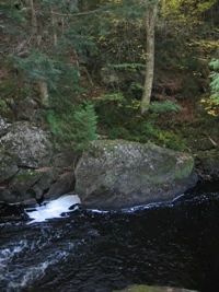
Photo by The U.S. Forest Service
Brunsweiler River and Mineral Lake feature a scenic, rocky river gorge incised in the upland of Keweenawan granite bedrock, and several high-quality old-growth hemlock-hardwood stands embedded in a large tract of maturing northern mesic hardwoods that includes some of the largest yellow birches on the forest. The closed canopy northern mesic forest is dominated by sugar maple, hemlock, and yellow birch. Snags and down woody debris are common. American fly honeysuckle is the dominant shrub with leatherwood, Canada yew, and alternate-leaved dogwood also present.
The ground flora is diverse. Grass and grass-like species include sedges, rattlesnake manna grass, and bottlebrush grass. Other herbaceous plants are club-moss, sessile-leaved bellwort, large-flowered trillium, rosy twisted stalk, dutchman's breeches, mountain wood sorrel, and three-leaved goldthread. The flora of the gorge varies considerably from the streamside to the adjacent ridge tops. The lowland areas and low, shaded cliffs are dominated by a canopy of white cedar, yellow birch, hemlock, and black ash. Canada yew and mountain maple are present in the midstory and on shaded cliff ledges. Ferns (especially Dryopteris) are abundant in the understory. Speckled alder dominates lower, wetter portions of the bank.
In this region, the Brunsweiler River flows north through a series of natural, glacially-created lakes, with high gradients and deeply-cut chasms between the lakes. The erosive power of the river has created numerous streamside cliffs, both open and shaded, some of which harbor a large population of the rare fragrant fern. The cliffs also afford habitat to Braun's holly fern. This stretch of river contains slack water, in the form of shallow pools, and is interspersed with rapids flowing over large, granitic boulders.
Two small, intermittent feeder streams, which drain the adjacent uplands, flow into the river from the east. A bridge crossing FR 187 spans the river and a footbridge for the North Country Trail crosses the river at the northern edge. The river itself is in natural condition, of high quality and supports a diverse fishery. Brunsweiler River and Mineral Lake is owned by the U.S. Forest Service and was designated a State Natural Area in 2007. This site is also recognized by the Forest Service as an established Research Natural Area.
Very few State Natural Areas have public facilities, but nearly all are open for a variety of recreational activities as indicated below. Generally, there are no picnic areas, restrooms, or other developments. Parking lots or designated parking areas are noted on individual SNA pages and maps. Trails, if present, are typically undesignated footpaths. If a developed trail is present, it will normally be noted on the SNA map located under the Map tab. A compass and topographic map or a GPS unit are useful tools for exploring larger, isolated SNAs.
The good majority of SNAs are isolated and have few or no facilities. Some SNAs have vehicle access lanes or parking lots, but their accessibility may vary depending on weather conditions. Parking lots and lanes are not plowed during winter. Hiking trails may be nonexistent or consist of undeveloped footpaths. A GPS unit or compass and a detailed topographic map are useful tools for exploring larger SNAs.
Non-DNR lands
Entrance fees: For non-DNR-owned SNAs, we are unaware of any vehicle or admission fees. However, please contact the landowner for more information.
Hunting and trapping
Other activities
Other allowable activities such as - but not limited to camping, geocaching and bicycling are determined by the landowner. Please contact them directly or visit their websites for details.
Location
Within the Chequamegon-Nicolet National Forest, Ashland County. T44N-R4W, Sections 10, 11, 14, 22, 23. 1,523 acres.
Driving directions
The site is located 8 miles west of Mellen. Take County Highway GG to FR 187, which passes along and then through the site.
The DNR's state natural areas program is comprised of lands owned by the state, private conservation organizations, municipalities, other governmental agencies, educational institutions, and private individuals. While the majority of SNAs are open to the public, access may vary according to individual ownership policies. Public use restrictions may apply due to public safety, or to protect endangered or threatened species or unique natural features. Lands may be temporarily closed due to specific management activities.
Users are encouraged to contact the landowner for more specific details. The data shown on these maps have been obtained from various sources, and are of varying age, reliability, and resolution. The data may contain errors or omissions and should not be interpreted as a legal representation of legal ownership boundaries. To create your custom map where you can zoom to a specific location, please use the DNR's Mapping Application.
Brunsweiler River and Mineral Lake are owned by: US Forest Service