Boscobel Bluffs
No. 683
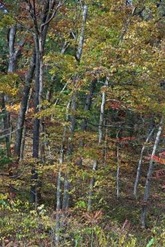
Photo by Thomas A. Meyer/DNR
Boscobel Bluffs form part of the uplands that define the south flank of the Lower Wisconsin River valley. Unique wind-blown features, rare dry prairie habitat, as well as oak savanna woodlands are found here. The natural area exhibits a diversity of topographic reliefs and exposures, from steep, wooded draws and north-facing hillsides, to level ridgetops and open, south-facing slopes. The summit of the bluff lies some 300' above the wide, sandy terraces of the river to the north.
Prevailing westerly winds over the post-glacial eons have moved some of these sands into the draws and up higher on the flanks. The dry prairie is situated on a west-facing slope with rock outcrops and small sandstone cliffs. Many representative species occur here including big bluestem, hairy grama grass, bottlebrush grass, leadplant, silky aster, and blazing star.
Along the ridge top and the south and west-facing slopes is an extensive oak opening with open-grown bur oaks with shagbark hickory and American hazelnut. Many Species of Greatest Conservation needs are present here. The oak/hickory-dominated forested portions of the site were also likely oak openings in the past but have succeeded in oak woodland in the absence of fire. Woody brush and invasive species management along with prescribed burning will improve the site's integrity and help maintain it into the future. Boscobel Bluffs is owned by the Mississippi Valley Conservancy and was designated a State Natural Area in 2017.
Very few State Natural Areas have public facilities, but nearly all are open for a variety of recreational activities as indicated below. Generally, there are no picnic areas, restrooms, or other developments. Parking lots or designated parking areas are noted on individual SNA pages and maps. Trails, if present, are typically undesignated footpaths. If a developed trail is present, it will normally be noted on the SNA map located under the Map tab. A compass and topographic map or a GPS unit are useful tools for exploring larger, isolated SNAs.
The good majority of SNAs are isolated and have few or no facilities. Some SNAs have vehicle access lanes or parking lots, but their accessibility may vary depending on weather conditions. Parking lots and lanes are not plowed during winter. Hiking trails may be nonexistent or consist of undeveloped footpaths. A GPS unit or compass and a detailed topographic map are useful tools for exploring larger SNAs.
Non-DNR lands
Entrance fees: For non-DNR-owned SNAs, we are unaware of any vehicle or admission fees. However, please contact the landowner for more information.
For available hunting opportunities, visit The Nature Conservancy's website: The Nature Conservancy [exit DNR].
NOTE: A tornado in 2021, impacted much of this SNA site and rendered it inaccessible due to downed trees and debris. However, the front part near the parking area has been cleared, so visitors can still hike in and see the best prairies before reaching impenetrable blowdown areas.
Hunting and trapping
Other activities
Other allowable activities such as - but not limited to camping, geocaching and bicycling are determined by the landowner. Please contact them directly or visit their websites for details.
Location
Grant County. T8N-R3W, Sections 25, 26, 35, 36. 384 acres.
Driving directions
From the intersection of Highways 61 and 133 in Boscobel, go north on 61 0.2 miles, then east on Mary Street and continue east on Fremont/County MS for a total of approximately 1.1 miles to the trailhead on the left.
The DNR's state natural areas program is comprised of lands owned by the state, private conservation organizations, municipalities, other governmental agencies, educational institutions, and private individuals. While the majority of SNAs are open to the public, access may vary according to individual ownership policies. Public use restrictions may apply due to public safety, or to protect endangered or threatened species or unique natural features. Lands may be temporarily closed due to specific management activities.
Users are encouraged to contact the landowner for more specific details. The data shown on these maps have been obtained from various sources, and are of varying age, reliability, and resolution. The data may contain errors or omissions and should not be interpreted as a legal representation of legal ownership boundaries. To create your custom map where you can zoom to a specific location, please use the DNR's Mapping Application.
Boscobel Bluffs is owned by: Mississippi Valley Conservancy