Border Lakes
No. 411
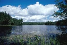
Photo by Gerald H. Emmerich, Jr
Border Lakes, also known as the Catherine Wolter Wilderness Area, features a natural mosaic of forest habitats interspersed with 15 undeveloped lakes and large ponds. Of significance are the lakes, both named and unnamed, which all have unaltered shorelines, an increasingly uncommon condition in northern Wisconsin.
In addition, the lakes have seen relatively little human activity over the last 60 years, allowing the biological structure of the lake communities to develop naturally. This has resulted in an unparalleled, representative group of aquatic ecosystems that are both functionally intact and remarkably similar within this ecoregion. Perhaps most remarkable is the fact that no non-native plant or animal species have yet been found in any of the lakes.
The pristine quality of the lakes along with their unique biological attributes makes them highly valuable as benchmarks for comparative research between managed and unmanaged lakes. As such, fishing is prohibited on some lakes as part of a long-term research project. Although logging has occurred throughout the site, the area still retains contiguous forest cover. Vegetation is varied and ranges from patches of very young aspen to near-mature stands of sugar maple, yellow birch, and hemlock.
Low, poorly drained soils support both open and forested wetland assemblages including open bog, white cedar swamp, black ash swamp, northern wet forest dominated by black spruce and tamarack, and alder thickets. Numerous birds are known to nest here including yellow-bellied sapsucker, great crested flycatcher, hermit thrush, ovenbird, and rose-breasted grosbeak. Border Lakes State Natural Area is owned by the Wisconsin Chapter of The Nature Conservancy and was designated a State Natural Area in 2004.
Very few State Natural Areas have public facilities, but nearly all are open for a variety of recreational activities as indicated below. Generally, there are no picnic areas, restrooms, or other developments. Parking lots or designated parking areas are noted on individual SNA pages and maps. Trails, if present, are typically undesignated footpaths. If a developed trail is present, it will normally be noted on the SNA map located under the Map tab. A compass and topographic map or a GPS unit are useful tools for exploring larger, isolated SNAs.
The good majority of SNAs are isolated and have few or no facilities. Some SNAs have vehicle access lanes or parking lots, but their accessibility may vary depending on weather conditions. Parking lots and lanes are not plowed during winter. Hiking trails may be nonexistent or consist of undeveloped footpaths. A GPS unit or compass and a detailed topographic map are useful tools for exploring larger SNAs.
Non-DNR lands
Entrance fees: For non-DNR-owned SNAs, we are unaware of any vehicle or admission fees. However, please contact the landowner for more information.
For available hunting opportunities, visit The Nature Conservancy's website: The Nature Conservancy [exit DNR].
Hunting and trapping
Other activities
Other allowable activities such as - but not limited to camping, geocaching and bicycling are determined by the landowner. Please contact them directly or visit their websites for details.
Location
Vilas County. T43N-R7E, Sections 4-8, 17, 20. T44N-R7E, Section 31. 2,383 acres.
Driving directions
From the intersection of County Highways K and M (Cut Off Rd) in Boulder Junction, go north on County M for 5 miles, northwest on County B for approximately 7 miles, then northeast on East Bay Road about 0.5 miles to a small parking area and trailhead on the east side of the road. Two hiking/skiing trails loop through the site. Motors are not allowed on any of the lakes.
The DNR's state natural areas program is comprised of lands owned by the state, private conservation organizations, municipalities, other governmental agencies, educational institutions, and private individuals. While the majority of SNAs are open to the public, access may vary according to individual ownership policies. Public use restrictions may apply due to public safety, or to protect endangered or threatened species or unique natural features. Lands may be temporarily closed due to specific management activities.
Users are encouraged to contact the landowner for more specific details. The data shown on these maps have been obtained from various sources, and are of varying age, reliability, and resolution. The data may contain errors or omissions and should not be interpreted as a legal representation of legal ownership boundaries. To create your custom map where you can zoom to a specific location, please use the DNR's Mapping Application.
Border Lakes is owned by: The Nature Conservancy