Borah Creek Prairie
No. 591
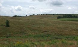
Photo by Thomas A. Meyer/DNR
Borah Creek Prairie contains dry-prairie remnants that support the state's third largest population of a federally-threatened plant with over 500 plants having been recorded in past surveys. The plant is considered a Midwest endemic species - one that is only found in the tallgrass prairie region of Wisconsin, Iowa, Minnesota, and Illinois. Borah Creek Prairie is part of the US Fish and Wildlife Service's federal recovery program which seeks to recover populations by protecting and expanding both existing and potential habitats in Wisconsin. The prairie contains the largest amount of suitable habitat for this plant in the state. Located in the rolling topography of the Driftless Area, the site supports small patches of higher-quality prairie within a matrix of surrogate grassland and is bisected by an intermittent stream.
Although grazed historically, a diversity of native plants can still be found here. Dominant grasses include big and little bluestem, Indian grass, side-oats grama, and prairie dropseed. Some of the forbs present are pasqueflower, cream wild indigo, rattlesnake master, rough blazing star, yellow coneflower, bird's-foot violet, downy gentian, and hoary puccoon. Grassland bird use of the area is extensive. Mississippi Valley Conservancy originally acquired the site with funding from the U.S. Fish and Wildlife Service and in 2010, ownership was transferred to The Prairie Enthusiasts. Borah Creek Prairie was designated a State Natural Area in 2009.
Very few State Natural Areas have public facilities, but nearly all are open for a variety of recreational activities as indicated below. Generally, there are no picnic areas, restrooms, or other developments. Parking lots or designated parking areas are noted on individual SNA pages and maps. Trails, if present, are typically undesignated footpaths. If a developed trail is present, it will normally be noted on the SNA map located under the Map tab. A compass and topographic map or a GPS unit are useful tools for exploring larger, isolated SNAs.
The good majority of SNAs are isolated and have few or no facilities. Some SNAs have vehicle access lanes or parking lots, but their accessibility may vary depending on weather conditions. Parking lots and lanes are not plowed during winter. Hiking trails may be nonexistent or consist of undeveloped footpaths. A GPS unit or compass and a detailed topographic map are useful tools for exploring larger SNAs.
Non-DNR lands
Entrance fees: For non-DNR-owned SNAs, we are unaware of any vehicle or admission fees. However, please contact the landowner for more information.
Hunting and trapping
Other activities
Other allowable activities such as - but not limited to camping, geocaching and bicycling are determined by the landowner. Please contact them directly or visit their websites for details.
Location
Grant County. T5N-R3W, Section 2. 140 acres.
Driving directions
From 18 and 61 in Fennimore, go west on 18 0.5 miles, then south on Rogers Street 0.5 miles. Continue south on Roger Hollow Road for 2.7 miles, then west on Townline Road for 0.8 miles, then south on Mt. Ridge Road for 0.3 miles to a farm lane on the west side of the road. Walk west on the lane into the site.
The DNR's state natural areas program is comprised of lands owned by the state, private conservation organizations, municipalities, other governmental agencies, educational institutions, and private individuals. While the majority of SNAs are open to the public, access may vary according to individual ownership policies. Public use restrictions may apply due to public safety, or to protect endangered or threatened species or unique natural features. Lands may be temporarily closed due to specific management activities.
Users are encouraged to contact the landowner for more specific details. The data shown on these maps have been obtained from various sources, and are of varying age, reliability, and resolution. The data may contain errors or omissions and should not be interpreted as a legal representation of legal ownership boundaries. To create your custom map where you can zoom to a specific location, please use the DNR's Mapping Application.
Borah Creek Prairie is owned by The Prairie Enthusiasts