Bohn Lake
No. 530
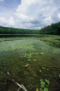
Photo by Thomas A. Meyer/DNR
Bohn Lake is a 13-acre, 24-foot deep hard-water seepage lake that is part of a geologically significant tunnel channel. Often part of a larger tunnel valley system, a tunnel channel is a large cavern created by a meltwater river flowing beneath the glacial ice. As a seepage lake, the Bohn Lake shoreline fluctuates anywhere from four to six feet depending on the hydrologic cycle and in some dry years contains little water. In wet years, abundant vegetation grows in distinctive concentric rings around the lake due to its fluctuating nature. Each ring has a different combination of species including numerous sedges, spike rushes, bulrushes, panic grasses, and silverweed. The lake also contains an abundance of floating leaved aquatics such as water lilies. The uplands, especially those to the north, contain formerly grazed but highly restorable savanna.
Many spring-blooming savanna indicators are present including shooting stars and puccoon. Other plants include New Jersey tea, lance-leaved ground cherry, Canadian milk vetch, round-headed bush clover, and hoary vervain. Animal life is diverse with birds such as turkey, tree swallow, northern oriole, great-crested flycatcher, the eastern wood pewee, chipping sparrow, eastern bluebird, red-eyed vireo, and wood thrush. Numerous invertebrates also use the area and include white-faced pondhawk dragonfly and pearl crescent, red admiral, and banded hairstreak butterflies. Bohn Lake is owned by the DNR and was designated a State Natural Area in 2008.
Very few State Natural Areas have public facilities, but nearly all are open for a variety of recreational activities as indicated below. Generally, there are no picnic areas, restrooms, or other developments. Parking lots or designated parking areas are noted on individual SNA pages and maps. Trails, if present, are typically undesignated footpaths. If a developed trail is present, it will normally be noted on the SNA map under the Maps tab. A compass and topographic map or a GPS unit are useful tools for exploring larger, isolated SNAs.
The good majority of SNAs are isolated and have few or no facilities. Some SNAs have vehicle access lanes or parking lots, but their accessibility may vary depending on weather conditions. Parking lots and lanes are not plowed during winter. Hiking trails may be nonexistent or consist of undeveloped footpaths. A GPS unit or compass and a detailed topographic map are useful tools for exploring larger SNAs.
Entrance fees: Except for Parfrey's Glen, the Cambrian Outlook in the Dells of the Wisconsin River, SNAs within State Parks and some within State Forests, all other DNR-owned SNAs do not have any admission fees. For more information, see Wis. Admin. Code NR 45. For non-DNR-owned SNAs, we are unaware of any vehicle or admission fees. However, please contact the landowner for more information.
For hunting or trapping opportunities, please see the hunting and trapping in State Parks page for details.
Allowable activities: DNR-owned land
The activities listed below are generally allowed on all DNR-owned SNA lands. Exceptions to this list of public uses, such as SNAs closed to hunting, are noted above and posted with signs on the property site.
- Hiking
- Fishing
- Cross country skiing
- Hunting
- Trapping
- Scientific research (permit required)
- Outdoor education
- Wild edibles (What is this?)
- Pets (Rules)
- Wildlife viewing
Prohibited activities: all SNAs
- Camping and campfires
- Collecting of animals (other than legally harvested species), non-edible fungi, rocks, minerals, fossils, archaeological artifacts, soil, downed wood, or any other natural material alive or dead.
- Collecting for scientific research requires a permit issued by the DNR
- Collecting of plants including seeds, roots or other non-edible parts of herbaceous plants such as wildflowers or grasses
- Geocaching
- Horseback riding
- Rock climbing
- Vehicles, including bicycles, ATVs, aircraft, and snowmobiles except on trails and roadways designated for their use.
For rules governing state-owned SNAs and other state lands, please consult Chapter NR 45 Wis. Admin. Code [exit DNR].
Location
Located within the Bohn Lake State Ice Age Trail Area, Waushara County. T19N-R9E, Section 16. 92 acres.
Driving directions
From the intersection of County FF (Main Street) and County V in Hancock, go east on V for 3.8 miles, then south and east on County B for 1 mile to a pull-off and trailhead on the east side of the road. The Ice Age National Scenic Trail winds through the site.
The DNR's state natural areas program is comprised of lands owned by the state, private conservation organizations, municipalities, other governmental agencies, educational institutions, and private individuals. While the majority of SNAs are open to the public, access may vary according to individual ownership policies. Public use restrictions may apply due to public safety, or to protect endangered or threatened species or unique natural features. Lands may be temporarily closed due to specific management activities.
Users are encouraged to contact the landowner for more specific details. The data shown on these maps have been obtained from various sources, and are of varying age, reliability, and resolution. The data may contain errors or omissions and should not be interpreted as a legal representation of legal ownership boundaries. To create your custom map where you can zoom to a specific location, please use the DNR's Mapping Application.
Bohn Lake is owned by: Wisconsin DNR