Blueberry Swamp
No. 518
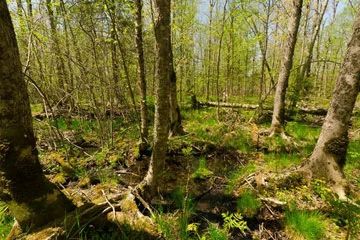
Photo by Josh Mayer
Blueberry Swamp occupies a drainage divide between the Brule River to the east and the Poplar River to the west. The eastern half comprises the headwaters region of Blueberry Creek, which flows southeast for 3 miles before joining Nebagamon Creek which continues east and enters the Brule River. Both the Brule and Poplar ultimately flow to Lake Superior. The core of the swamp holds mineral-rich waters and harbors a forest of black ash and white cedar.
Canopy associates include yellow birch, paper birch, and red maple. The structural diversity of the swamp is increasing with large trees, standing snags, coarse woody debris, and tip-up mounds. The tall shrub layer is composed of alder, red-osier dogwood, highbush cranberry, and winterberry. Characteristic herbs and low shrubs include sensitive fern, cinnamon fern, royal fern, dwarf raspberry, fowl manna grass, marsh marigold, skunk cabbage, and numerous sedges. Pools of standing water up to 15 cm deep are frequent throughout.
The swamp provides important habitat for numerous rare plants and animals including a diverse array of orchids. The relatively undisturbed core of this site makes it an extremely valuable ecological reference area since it has been rated one of the top hardwood swamps in all of northern Wisconsin. The value of this site is compounded by its large size, diverse biota, and its position as source water for two outstanding streams - Nebagamon Creek and Blueberry Creek, which provide clean water to the Brule River, one of Wisconsin's most highly regarded trout streams. Blueberry Swamp is owned by Douglas County and was designated a State Natural Area in 2007.
Very few State Natural Areas have public facilities, but nearly all are open for a variety of recreational activities as indicated below. Generally, there are no picnic areas, restrooms, or other developments. Parking lots or designated parking areas are noted on individual SNA pages and maps. Trails, if present, are typically undesignated footpaths. If a developed trail is present, it will normally be noted on the SNA map located under the Map tab. A compass and topographic map or a GPS unit are useful tools for exploring larger, isolated SNAs.
The good majority of SNAs are isolated and have few or no facilities. Some SNAs have vehicle access lanes or parking lots, but their accessibility may vary depending on weather conditions. Parking lots and lanes are not plowed during winter. Hiking trails may be nonexistent or consist of undeveloped footpaths. A GPS unit or compass and a detailed topographic map are useful tools for exploring larger SNAs.
Non-DNR lands
Entrance fees: For non-DNR-owned SNAs, we are unaware of any vehicle or admission fees. However, please contact the landowner for more information.
Hunting and trapping
Other activities
Other allowable activities such as - but not limited to camping, geocaching and bicycling are determined by the landowner. Please contact them directly or visit their websites for details.
Location
Within the Douglas County Forest. T47N-R10W, Sections 7, 18. T47N-R11W, Sections 12, 13. 864 acres.
Driving directions
From the intersection of Highway 2 and County P just east of Poplar, go south on P for 1.5 miles, then east on E. Middle River Road for 2.9 miles, then continue east on County F for nearly 1 mile. Park and walk east into the site.
The DNR's state natural areas program is comprised of lands owned by the state, private conservation organizations, municipalities, other governmental agencies, educational institutions, and private individuals. While the majority of SNAs are open to the public, access may vary according to individual ownership policies. Public use restrictions may apply due to public safety, or to protect endangered or threatened species or unique natural features. Lands may be temporarily closed due to specific management activities.
Users are encouraged to contact the landowner for more specific details. The data shown on these maps have been obtained from various sources, and are of varying age, reliability, and resolution. The data may contain errors or omissions and should not be interpreted as a legal representation of legal ownership boundaries. To create your custom map where you can zoom to a specific location, please use the DNR's Mapping Application.
Blueberry Swamp is owned by: Douglas County