Blomberg Lake and Woods
No. 392
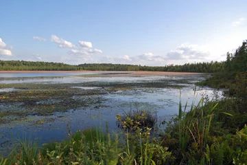
Photo by Joshua D. Sulman
Located within a sandy glacial plain, Blomberg Lake is a 68-acre bog lake surrounded by a northern wet forest. With a maximum depth of four feet, this shallow lake supports only a few aquatic plants including white and yellow water lilies and large-leaved pondweed. The surrounding wet forest is dominated by tamarack with red maple, some black spruce, and a shrub layer of speckled alder. The understory varies locally from Labrador-tea to three-seeded sedge to alder.
Further from the margin of the lake are many wetland grasses and sedges in the herbaceous layer such as blue-joint grass, drooping wood-reed, bristly sedge, American woolly-fruit sedge, yellow blue-bead-lily, sweet gale, marsh skullcap, and American starflower.
Northern mesic (wet) forests are very rare in this region and the best example is in the southwest part of the site. The forest is dominated by sugar maple and red maple with lesser amounts of northern red oak, white oak, basswood, trembling aspen, and birch. The ground layer has areas of Pennsylvania sedge, round-lobed hepatic, bracken fern, maidenhair fern, black snakeroot, bottlebrush grass, and hairy sweet cicely. Migratory waterfowl often use the lake and surrounding wetlands. Blomberg Lake is owned by the DNR and was designated a State Natural Area in 2003.
Very few State Natural Areas have public facilities, but nearly all are open for a variety of recreational activities as indicated below. Generally, there are no picnic areas, restrooms, or other developments. Parking lots or designated parking areas are noted on individual SNA pages and maps. Trails, if present, are typically undesignated footpaths. If a developed trail is present, it will normally be noted on the SNA map under the Maps tab. A compass and topographic map or a GPS unit are useful tools for exploring larger, isolated SNAs.
The good majority of SNAs are isolated and have few or no facilities. Some SNAs have vehicle access lanes or parking lots, but their accessibility may vary depending on weather conditions. Parking lots and lanes are not plowed during winter. Hiking trails may be nonexistent or consist of undeveloped footpaths. A GPS unit or compass and a detailed topographic map are useful tools for exploring larger SNAs.
Entrance fees: Except for Parfrey's Glen, the Cambrian Outlook in the Dells of the Wisconsin River, SNAs within State Parks and some within State Forests, all other DNR-owned SNAs do not have any admission fees. For more information, see Wis. Admin. Code NR 45. For non-DNR-owned SNAs, we are unaware of any vehicle or admission fees. However, please contact the landowner for more information.
Allowable activities: DNR-owned land
The activities listed below are generally allowed on all DNR-owned SNA lands. Exceptions to this list of public uses, such as SNAs closed to hunting, are noted above and posted with signs on the property site.
- Hiking
- Fishing
- Cross country skiing
- Hunting
- Trapping
- Scientific research (permit required)
- Outdoor education
- Wild edibles (What is this?)
- Pets (Rules)
- Wildlife viewing
Prohibited activities: all SNAs
- Camping and campfires
- Collecting of animals (other than legally harvested species), non-edible fungi, rocks, minerals, fossils, archaeological artifacts, soil, downed wood, or any other natural material alive or dead.
- Collecting for scientific research requires a permit issued by the DNR
- Collecting of plants including seeds, roots or other non-edible parts of herbaceous plants such as wildflowers or grasses
- Geocaching
- Horseback riding
- Rock climbing
- Vehicles, including bicycles, ATVs, aircraft, and snowmobiles except on trails and roadways designated for their use.
For rules governing state-owned SNAs and other state lands, please consult Chapter NR 45 Wis. Admin. Code [exit DNR].
Location
Within Amsterdam Sloughs Wildlife Area, Burnett County. T38N-R17W, Sections 3, 4. T39N-R17W, Sections 33, 34. 966 acres.
Driving directions
From the intersection of Highways 35 and 70 in Siren, go west on 70 for 3.7 miles, then west and north on County N for 2.5 miles, then east on an access trail 0.4 miles and park. Walk east 0.1 miles to the lake.
The DNR's state natural areas program is comprised of lands owned by the state, private conservation organizations, municipalities, other governmental agencies, educational institutions, and private individuals. While the majority of SNAs are open to the public, access may vary according to individual ownership policies. Public use restrictions may apply due to public safety, or to protect endangered or threatened species or unique natural features. Lands may be temporarily closed due to specific management activities.
Users are encouraged to contact the landowner for more specific details. The data shown on these maps have been obtained from various sources, and are of varying age, reliability, and resolution. The data may contain errors or omissions and should not be interpreted as a legal representation of legal ownership boundaries. To create your custom map where you can zoom to a specific location, please use the DNR's Mapping Application.
Blomberg Lake and Woods is owned by: Wisconsin DNR
Management objectives and prescriptions
Read the Glacial Lake Grantsburg Properties Master Plan
Amsterdam Sloughs Wildlife Area
Glacial Lake Grantsburg Master Plan