Blackhawk Island
No. 77
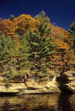
Photo by Thomas A. Meyer/DNR
Blackhawk Island State Natural Area is a wooded island in the Wisconsin River, which has cut deep narrow gorges here in the Cambrian sandstone. The site features diverse upland forest types and cliffs with rich floras at the Dells of the Wisconsin River. The terrain is varied, consisting of ridges, gorges, cliffs, rock outcrops and some level ground. The soils are dominated by sands and sandy loams of eleven different soil series.
The island has several community types, all relatively undisturbed, with white oak, red oak, white pine, sugar maple, basswood, hemlock, white cedar, yellow birch, river birch, cottonwood and red maple, each found dominating in specific areas. For example, white oak and white pine are the dominant species on the north shore.
Numerous gorges provide unique habitats. Especially common are ferns; nearly one-third of the taxa of Wisconsin are present. Birds are equally diverse with species having both northern and southern affinities present. Deer exclosures are present and demonstrate the impact that overbrowsing has had on the understory. Blackhawk Island is owned by the University of Wisconsin and was designated a State Natural Area in 1969.
Very few State Natural Areas have public facilities, but nearly all are open for a variety of recreational activities as indicated below. Generally, there are no picnic areas, restrooms, or other developments. Parking lots or designated parking areas are noted on individual SNA pages and maps. Trails, if present, are typically undesignated footpaths. If a developed trail is present, it will normally be noted on the SNA map located under the Map tab. A compass and topographic map or a GPS unit are useful tools for exploring larger, isolated SNAs.
The good majority of SNAs are isolated and have few or no facilities. Some SNAs have vehicle access lanes or parking lots, but their accessibility may vary depending on weather conditions. Parking lots and lanes are not plowed during winter. Hiking trails may be nonexistent or consist of undeveloped footpaths. A GPS unit or compass and a detailed topographic map are useful tools for exploring larger SNAs.
Non-DNR lands
Entrance fees: For non-DNR-owned SNAs, we are unaware of any vehicle or admission fees. However, please contact the landowner for more information.
From the intersection of Highways 12 and 13, on the west side of Wisconsin Dells, go west (north) on Highway 12 0.6 mile, then right (north) on County A (which changes to County Highway N in Juneau County) for 1.1 miles to the Upham Woods Outdoor Learning Center.
Access is limited to scientific or educational groups only. Please contact Upham Woods staff for access permission: 608-254-6461.
Hunting and trapping
Other activities
Other allowable activities such as - but not limited to camping, geocaching and bicycling are determined by the landowner. Please contact them directly or visit their websites for details.
Location
Juneau County. T14N-R6E, Sections 32, 33. 192 acres.
Driving directions
From the intersection of Highways 12 and 13, on the west side of Wisconsin Dells, go west (north) on Highway 12 0.6 mile, then right (north) on County Highway A (which changes to County Highway N in Juneau County) for 1.1 miles to the Upham Woods Outdoor Learning Center. Access is limited to scientific or educational groups only. Please contact Upham Woods staff for access permission: 608-254-6461.
The DNR's state natural areas program is comprised of lands owned by the state, private conservation organizations, municipalities, other governmental agencies, educational institutions, and private individuals. While the majority of SNAs are open to the public, access may vary according to individual ownership policies. Public use restrictions may apply due to public safety, or to protect endangered or threatened species or unique natural features. Lands may be temporarily closed due to specific management activities.
Users are encouraged to contact the landowner for more specific details. The data shown on these maps have been obtained from various sources, and are of varying age, reliability, and resolution. The data may contain errors or omissions and should not be interpreted as a legal representation of legal ownership boundaries. To create your custom map where you can zoom to a specific location, please use the DNR's Mapping Application.
Blackhawk Island is owned by: the UW Board of Regents