Black Lake Bog
No. 196
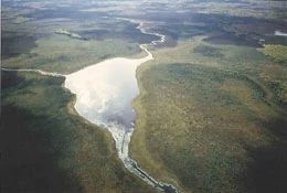
Photo by MN DNR
Located on the end moraine, Black Lake Bog contains a vast, inaccessible, undisturbed wetland complex of bog lake, open bog, and northern wet forest, a community poorly represented in the younger drift, west zone. The open bog is dominated by a leather leaf with patches of bog-rosemary. Black spruce is scattered in the bog and are usually stunted but occasionally grows into a dense stand of full-sized trees.
The bog and Black Lake form the headwaters of the Black River. Black Lake is entirely muck-bottomed and has a maximum depth of 4 feet, methyl purple alkalinity of 28 ppm, and a Secchi disk reading of 3 feet. Black River has a gradient of 22 feet/mile and methyl purple alkalinity of 41 ppm. The river below the outlet averages 2.5 cu. Ft./sec.
Wildlife found on the tract includes waterfowl, great blue heron, beaver, and a short-eared owl that may nest in the bog. Black Lake Bog is owned by Douglas County and was designated a State Natural Area in 1985. The portion of the bog in Minnesota is designated a Scientific and Natural Area.
Very few State Natural Areas have public facilities, but nearly all are open for a variety of recreational activities as indicated below. Generally, there are no picnic areas, restrooms, or other developments. Parking lots or designated parking areas are noted on individual SNA pages and maps. Trails, if present, are typically undesignated footpaths. If a developed trail is present, it will normally be noted on the SNA map and/or under the "Access" tab. A compass and topographic map or a GPS unit are useful tools for exploring larger, isolated SNAs.
The good majority of SNAs are isolated and have few or no facilities. Some SNAs have vehicle access lanes or parking lots, but their accessibility may vary depending on weather conditions. Parking lots and lanes are not plowed during winter. Hiking trails may be nonexistent or consist of undeveloped footpaths. A GPS unit or compass and a detailed topographic map are useful tools for exploring larger SNAs.
Non-DNR lands
Entrance fees: For non-DNR-owned SNAs, we are unaware of any vehicle or admission fees. However, please contact the landowner for more information.
Hunting and trapping
Other activities
Other allowable activities such as - but not limited to camping, geocaching and bicycling are determined by the landowner. Please contact them directly or visit their websites for details.
Location
Within the Douglas County Forest. Douglas County. T45N-R15W, Sections 8, 17, 18, 19, 20, 29, 30. 2,008 acres.
Driving directions
This huge, roadless wetland straddles the Wisconsin-Minnesota boundary and the western portion is designated a Minnesota Scientific and Natural Area. The easiest access to the best open peatlands and Black Lake is from the Minnesota side via the Gandy Dancer State Trail.
The trail is open for ATVs, horses, and snowmobiles, and can be accessed at numerous road intersections to the north and south of the natural area. The closest walk-in access from the Wisconsin side to the easternmost peatlands is from South Summit Trail Road. Refer to maps and satellite imagery for entry options. Water access via the Black River is not recommended.
The DNR's state natural areas program is comprised of lands owned by the state, private conservation organizations, municipalities, other governmental agencies, educational institutions, and private individuals. While the majority of SNAs are open to the public, access may vary according to individual ownership policies. Public use restrictions may apply due to public safety, or to protect endangered or threatened species or unique natural features. Lands may be temporarily closed due to specific management activities.
Users are encouraged to contact the landowner for more specific details. The data shown on these maps have been obtained from various sources, and are of varying age, reliability, and resolution. The data may contain errors or omissions and should not be interpreted as a legal representation of legal ownership boundaries. To create your custom map where you can zoom to a specific location, please use the DNR's Mapping Application.
Black Lake Bog is owned by: Douglas County