Black Earth Rettenmund Prairie
No. 210
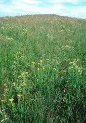
Photo by Thomas A. Meyer/DNR
Situated on a low Driftless Area ridge, Black Earth Rettenmund Prairie features a small, but intact dry-mesic prairie and harbors a rich flora of more than 80 native prairie species. Grasses include big and little blue-stem, Indian grass, northern drop-seed, purple love grass, June grass and numerous Panicum species. Forbs include such showy species as pasque flower, lead-plant, shooting-star, fringed puccoon, compass-plant, blazing-stars, purple prairie-clover, yellow coneflower, black-eyed susan, sunflowers, goldenrods and asters. Of significance are the uncommon species white camas and pomme-de-prairie.
Many birds use the prairie and surrounding area for nesting including the eastern kingbird, indigo bunting, and eastern bluebird. The site also provides a habitat for a variety of insects and butterflies. The area has a history of light grazing and although it was never plowed, old furrow marks on the crest are indicative of an old tractor pathway. Today, management activities such as brushing, burning and mowing help maintain the prairie landscape. Black Earth Prairie is owned by The Prairie Enthusiasts and was designated a State Natural Area in 1986.
Very few State Natural Areas have public facilities, but nearly all are open for a variety of recreational activities as indicated below. Generally, there are no picnic areas, restrooms, or other developments. Parking lots or designated parking areas are noted on individual SNA pages and maps. Trails, if present, are typically undesignated footpaths. If a developed trail is present, it will normally be noted on the SNA map located under the Map tab. A compass and topographic map or a GPS unit are useful tools for exploring larger, isolated SNAs.
The good majority of SNAs are isolated and have few or no facilities. Some SNAs have vehicle access lanes or parking lots, but their accessibility may vary depending on weather conditions. Parking lots and lanes are not plowed during winter. Hiking trails may be nonexistent or consist of undeveloped footpaths. A GPS unit or compass and a detailed topographic map are useful tools for exploring larger SNAs.
Non-DNR lands
Entrance fees: For non-DNR-owned SNAs, we are unaware of any vehicle or admission fees. However, please contact the landowner for more information.
Hunting and trapping
Other activities
Other allowable activities such as - but not limited to camping, geocaching and bicycling are determined by the landowner. Please contact them directly or visit their websites for details.
Location
Dane County. T8N-R6E, Section 27 SW¼. 17 acres.
Driving directions
From the intersection of Highways 78 and KP in Black Earth, go west on KP for 1.1 miles, then south on F for 0.25 miles, then west on Fesenfeld Road for 0.2 miles to a small parking area south of the road.
The DNR's state natural areas program is comprised of lands owned by the state, private conservation organizations, municipalities, other governmental agencies, educational institutions, and private individuals. While the majority of SNAs are open to the public, access may vary according to individual ownership policies. Public use restrictions may apply due to public safety, or to protect endangered or threatened species or unique natural features. Lands may be temporarily closed due to specific management activities.
Users are encouraged to contact the landowner for more specific details. The data shown on these maps have been obtained from various sources, and are of varying age, reliability, and resolution. The data may contain errors or omissions and should not be interpreted as a legal representation of legal ownership boundaries. To create your custom map where you can zoom to a specific location, please use the DNR's Mapping Application.
Black Earth Rettenmund Prairie is owned by: The Prairie Enthusiasts