Black Creek Bog
No. 433
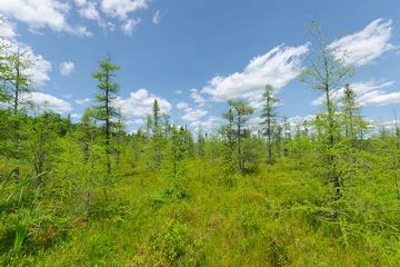
Photo by Josh Mayer
Black Creek Bog forms one of the largest open heath bog complexes with boreal attributes on the Glidden Drumlins land type. It is predominately a large open sphagnum bog dominated by sphagnum, Carex oligospermia, and ericaceous shrubs including Labrador tea, bog laurel, bog rosemary, leatherleaf, and small cranberry.
Patches of stunted black spruce and tamarack woodland are also present. Surrounding the bog is an upland forested area dominated by fire-origin red pine, paper birch, and white spruce growing on a narrow gravel esker. Overstory trees are generally in the 8-12" diameter range with a few large white spruce greater than 16" in diameter.
Typical understory plants include bracken fern, poverty oats, club mosses, blueberry, Labrador tea, wintergreen, and other "boreal" associated plants. The site serves as the headwaters of Black Creek, a dark, warm water drainage stream that flows into the Moose River. This is an important area for boreal birds including gray jay, boreal chickadee and spruce grouse. Black Creek Bog is owned by the US Forest Service and was designated a State Natural Area in 2007.
Pine reproduction is generally sparse, though pockets of sapling white pine occur. Most of the reproducing trees are hardwoods. The shrub layer is moderate to dense with beaked hazelnut, serviceberry, and Rubus spp. Characteristic herbs include bracken fern, winterberry, large-leaved aster, early low blueberry, velvet-leaf blueberry, narrow-leaved cow-wheat, and lycopods. There has been little to no disturbance in this stand since the cut-over logging era, probably about 80-100 years ago. Bearsdale Creek and Hyatt Springs are owned by the U.S. Forest Service and were designated a State Natural Area in 2007. This site is also recognized by the Forest Service as an established Research Natural Area.
Very few State Natural Areas have public facilities, but nearly all are open for a variety of recreational activities as indicated below. Generally, there are no picnic areas, restrooms, or other developments. Parking lots or designated parking areas are noted on individual SNA pages and maps. Trails, if present, are typically undesignated footpaths.If a developed trail is present, it will normally be noted on the SNA map located under the Map tab. A compass and topographic map or a GPS unit are useful tools for exploring larger, isolated SNAs.
The good majority of SNAs are isolated and have few or no facilities. Some SNAs have vehicle access lanes or parking lots, but their accessibility may vary depending on weather conditions. Parking lots and lanes are not plowed during winter. Hiking trails may be nonexistent or consist of undeveloped footpaths. A GPS unit or compass and a detailed topographic map are useful tools for exploring larger SNAs.
Non-DNR lands
Entrance fees: For non-DNR-owned SNAs, we are unaware of any vehicle or admission fees. However, please contact the landowner for more information.
Hunting and trapping
Other activities
Other allowable activities such as - but not limited to camping, geocaching and bicycling are determined by the landowner. Please contact them directly or visit their websites for details.
Location
Within the Chequamegon-Nicolet National Forest, Ashland County. T41N-R4W, Sections 10-15. 576 acres.
Driving directions
The site is located 10 miles south of Clam Lake. From the intersection of County GG and Highway 77, go south on GG 8.5 miles, then east 0.5 miles on FR 164. The site lies northeast of the road.
The DNR's state natural areas program is comprised of lands owned by the state, private conservation organizations, municipalities, other governmental agencies, educational institutions, and private individuals. While the majority of SNAs are open to the public, access may vary according to individual ownership policies. Public use restrictions may apply due to public safety, or to protect endangered or threatened species or unique natural features. Lands may be temporarily closed due to specific management activities.
Users are encouraged to contact the landowner for more specific details. The data shown on these maps have been obtained from various sources, and are of varying age, reliability, and resolution. The data may contain errors or omissions and should not be interpreted as a legal representation of legal ownership boundaries. To create your custom map where you can zoom to a specific location, please use the DNR's Mapping Application.
Black Creek Bog is owned by: The US Forest Service