Bittersweet Lakes
No. 34
<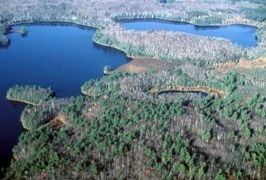
Photo by Eric Epstein
Four soft water seepage lakes, each separated by an isthmus are the main features of the natural area. The lakes are Bittersweet (104 acres, 31 feet), Oberlin (46 acres, 25 feet), Smith (43 acres, 18 feet), and Prong (30 acres, 50 feet), and all have a variety of bottom substrates, ranging from sand and gravel to rock and muck, are slightly acidic, and have relatively high water clarity. Water levels fluctuate slightly each year.
The aquatic vegetation consists of many unusual plants including seven-angle pipewort, watershield, bur-reeds, golden pert, quillworts, water lobelia and waterweed. In some areas, lake pockets contain leatherleaf dominant bog vegetation. The shoreline vegetation consists of a narrow zone of shrubs such as leatherleaf, alders, and meadowsweet, which changes abruptly to uplands. Northwest of Smith Lake and west of Oberlin Lake is an old-growth northern mesic forest remnant of hemlock and yellow birch; a black spruce-tamarack bog is located west of Smith Lake.
White pine, red oak and birch dominate the forest found between Bittersweet and Prong Lakes, and a second-growth northern dry-mesic forest composed of paper birch, aspen, red maple, red oak, and lesser amounts of white pine, occurs in other areas. The fishery consists of walleye, northern pike, large and smallmouth bass, and panfish. Many diving ducks use the lakes during migration and common loons have nested in the tract. Bittersweet Lakes is owned by the DNR and was designated a State Natural Area in 1958.
Very few State Natural Areas have public facilities, but nearly all are open for a variety of recreational activities as indicated below. Generally, there are no picnic areas, restrooms, or other developments. Parking lots or designated parking areas are noted on individual SNA pages and maps. Trails, if present, are typically undesignated footpaths. If a developed trail is present, it will normally be noted on the SNA map under the Maps tab. A compass and topographic map or a GPS unit are useful tools for exploring larger, isolated SNAs.
The good majority of SNAs are isolated and have few or no facilities. Some SNAs have vehicle access lanes or parking lots, but their accessibility may vary depending on weather conditions. Parking lots and lanes are not plowed during winter. Hiking trails may be nonexistent or consist of undeveloped footpaths. A GPS unit or compass and a detailed topographic map are useful tools for exploring larger SNAs.
Entrance fees: Except for Parfrey's Glen, the Cambrian Outlook in the Dells of the Wisconsin River, SNAs within State Parks and some within State Forests, all other DNR-owned SNAs do not have any admission fees. For more information, see Wis. Admin. Code NR 45. For non-DNR-owned SNAs, we are unaware of any vehicle or admission fees. However, please contact the landowner for more information.
Allowable activities: DNR-owned land
The activities listed below are generally allowed on all DNR-owned SNA lands. Exceptions to this list of public uses, such as SNAs closed to hunting, are noted above and posted with signs on the property site.
- Hiking
- Fishing
- Cross country skiing
- Hunting
- Trapping
- Scientific research (permit required)
- Outdoor education
- Wild edibles (What is this?)
- Pets (Rules)
- Wildlife viewing
Prohibited activities: all SNAs
- Camping and campfires
- Collecting of animals (other than legally harvested species), non-edible fungi, rocks, minerals, fossils, archaeological artifacts, soil, downed wood, or any other natural material alive or dead.
- Collecting for scientific research requires a permit issued by the DNR
- Collecting of plants including seeds, roots or other non-edible parts of herbaceous plants such as wildflowers or grasses
- Geocaching
- Horseback riding
- Rock climbing
- Vehicles, including bicycles, ATVs, aircraft, and snowmobiles except on trails and roadways designated for their use.
For rules governing state-owned SNAs and other state lands, please consult Chapter NR 45 Wis. Admin. Code [exit DNR].
Location
Within the Northern Highland-American Legion State Forest, Vilas County. T40N-R7E, Sections 14, 15, 21, 22, 27. 1,070 acres.
Driving directions
From the intersection of Highways 155 and 70 in St. Germain, go west on 70 5.7 miles, then north on an unnamed gravel access road (marked by a "Bittersweet Wild Lakes" sign) for about 0.7 miles to a fork, then take the right fork another 0.3 miles to a carry-in canoe launch on the southwest side of Bittersweet Lake.
Please note: the road is a low-maintenance road and high clearance vehicles with all-wheel or four-wheel drive are recommended. The four lakes are connected by short overland portages marked by signs. Primitive camping is available at five reservable shoreline campsites. No motors of any kind are allowed on the four lakes.
The DNR's state natural areas program is comprised of lands owned by the state, private conservation organizations, municipalities, other governmental agencies, educational institutions, and private individuals. While the majority of SNAs are open to the public, access may vary according to individual ownership policies. Public use restrictions may apply due to public safety, or to protect endangered or threatened species or unique natural features. Lands may be temporarily closed due to specific management activities.
Users are encouraged to contact the landowner for more specific details. The data shown on these maps have been obtained from various sources, and are of varying age, reliability, and resolution. The data may contain errors or omissions and should not be interpreted as a legal representation of legal ownership boundaries. To create your custom map where you can zoom to a specific location, please use the DNR's Mapping Application.
Bittersweet Lakes is owned by: Wisconsin DNR