Big Manitou Falls and Gorge
No. 398
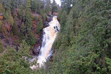
Photo by Kevin Feind
Big Manitou Falls and Gorge contains a unique river gorge carved out of both sandstone and basalt and includes the 165' high roaring, cascading falls of the Black River. In the few thousand years since the last glacier retreated, the river slowly eroded through the layers of soft sandstone and clay and gradually formed the steep-sided gorge. However, underlying much of the area is basalt, a strong and resistant product of deep volcanic action that occurred over a billion years ago.
While the river forged a relatively easy pathway through the sandstone, upon meeting the resistant lava rock, the river could not erode as rapidly, and the water's power was expended downwards, creating Big Manitou Falls. The fourth highest waterfall east of the Rocky Mountains, its name comes from Native Americans who said they heard the voice of the Great Spirit in the roaring of the falls - calling it "Gitchee Manitou". Two rare species have been found within the rocky gorge. Big Manitou Falls and Gorge is owned by the DNR and was designated a State Natural Area in 2003.
Very few State Natural Areas have public facilities, but nearly all are open for a variety of recreational activities as indicated below. Generally, there are no picnic areas, restrooms, or other developments. Parking lots or designated parking areas are noted on individual SNA pages and maps. Trails, if present, are typically undesignated footpaths. If a developed trail is present, it will normally be noted on the SNA map under the Maps tab. A compass and topographic map or a GPS unit are useful tools for exploring larger, isolated SNAs.
The good majority of SNAs are isolated and have few or no facilities. Some SNAs have vehicle access lanes or parking lots, but their accessibility may vary depending on weather conditions. Parking lots and lanes are not plowed during winter. Hiking trails may be nonexistent or consist of undeveloped footpaths. A GPS unit or compass and a detailed topographic map are useful tools for exploring larger SNAs.
Entrance fees: Except for Parfrey's Glen, the Cambrian Outlook in the Dells of the Wisconsin River, SNAs within State Parks and some within State Forests, all other DNR-owned SNAs do not have any admission fees. For more information, see Wis. Admin. Code NR 45. For non-DNR-owned SNAs, we are unaware of any vehicle or admission fees. However, please contact the landowner for more information.
Allowable activities: DNR-owned land
The activities listed below are generally allowed on all DNR-owned SNA lands. Exceptions to this list of public uses, such as SNAs closed to hunting, are noted above and posted with signs on the property site.
- Hiking
- Fishing
- Cross country skiing
- Hunting
- Trapping
- Scientific research (permit required)
- Outdoor education
- Wild edibles (What is this?)
- Pets (Rules)
- Wildlife viewing
Prohibited activities: all SNAs
- Camping and campfires
- Collecting of animals (other than legally harvested species), non-edible fungi, rocks, minerals, fossils, archaeological artifacts, soil, downed wood, or any other natural material alive or dead.
- Collecting for scientific research requires a permit issued by the DNR
- Collecting of plants including seeds, roots or other non-edible parts of herbaceous plants such as wildflowers or grasses
- Geocaching
- Horseback riding
- Rock climbing
- Vehicles, including bicycles, ATVs, aircraft, and snowmobiles except on trails and roadways designated for their use.
For rules governing state-owned SNAs and other state lands, please consult Chapter NR 45 Wis. Admin. Code [exit DNR].
Location
Within Pattison State Park, Douglas County. T47N-R14W, Section 21. 35 acres.
Driving directions
From the intersection of Highways 35 and 105 in South Superior, go south on 35 8.9 miles to the park entrance. Get a map at the contact station. The natural area can be accessed via the Big Manitou Falls Trail.
The DNR's state natural areas program is comprised of lands owned by the state, private conservation organizations, municipalities, other governmental agencies, educational institutions, and private individuals. While the majority of SNAs are open to the public, access may vary according to individual ownership policies. Public use restrictions may apply due to public safety, or to protect endangered or threatened species or unique natural features. Lands may be temporarily closed due to specific management activities.
Users are encouraged to contact the landowner for more specific details. The data shown on these maps have been obtained from various sources, and are of varying age, reliability, and resolution. The data may contain errors or omissions and should not be interpreted as a legal representation of legal ownership boundaries. To create your custom map where you can zoom to a specific location, please use the DNR's Mapping Application.
Big Manitou Falls and Gorge is owned by: Wisconsin DNR