Big Island
No. 384
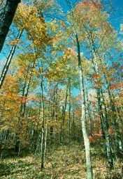
Photo by Thomas A. Meyer/DNR
Big Island contains maturing examples of the northern dry and dry-mesic forest, and northern wet forest along with forest seeps and a very diverse reach of the St. Croix River containing numerous aquatic invertebrates. The island rises about 100’ above the river and is forested with second-growth aspen and paper birch with old-growth white pine and basswood occurring on north-facing slopes. Shrubs include nannyberry, American fly honeysuckle, eastern leatherwood, and norbush honeysuckle suckle.
The ground layer is rich in plant species diversity and concludes mosses, blueberries, maidenhair fern, wild sarsaparilla, blue cohosh, yellow-blue-bead lily, partridgeberry, and numerous spring ephemerals. The northwest and eastern tip of the island are lower and wetter with species such as white spruce, marsh bluegrass, and northern blue flag iriswool grass-grass. Numerous seeps and north-south aspects add to the site variability creating numerous microhabitats for flora and fauna. Big Island is owned by the National Park Service and was designated a State Natural Area in 2002.
Very few State Natural Areas have public facilities, but nearly all are open for a variety of recreational activities as indicated below. Generally, there are no picnic areas, restrooms, or other developments. Parking lots or designated parking areas are noted on individual SNA pages and maps. Trails, if present, are typically undesignated footpaths. If a developed trail is present, it will normally be noted on the SNA map located under the Map tab. A compass and topographic map or a GPS unit are useful tools for exploring larger, isolated SNAs.
The good majority of SNAs are isolated and have few or no facilities. Some SNAs have vehicle access lanes or parking lots, but their accessibility may vary depending on weather conditions. Parking lots and lanes are not plowed during winter. Hiking trails may be nonexistent or consist of undeveloped footpaths. A GPS unit or compass and a detailed topographic map are useful tools for exploring larger SNAs.
Non-DNR lands
Entrance fees: For non-DNR-owned SNAs, we are unaware of any vehicle or admission fees. However, please contact the landowner for more information.
Hunting and trapping
Other activities
Other allowable activities such as - but not limited to camping, geocaching and bicycling are determined by the landowner. Please contact them directly or visit their websites for details.
Location
Within the St. Croix National Scenic Riverway, Burnett County. T41N-R15W, Sections 4, 5. T41N-R16W, Sections 1, 2, 11. T42N-R14W, Section 30. T42N-R15W, Sections 25, 31-36. T42N-R16W, Section 36. 1450 acres. Section 30. T42N-R15W, Sections 25, 31-36. T42N-R16W, Section 36. 1450 acres.
Driving directions
The area is best seen by boat. For walk-in access: from Riverside, go north on 35 across the bridge 0.7 miles, then east on Big Island Road 0.3 miles to an access lane. Cross the stream and walk south onto the island.
The DNR's state natural areas program is comprised of lands owned by the state, private conservation organizations, municipalities, other governmental agencies, educational institutions, and private individuals. While the majority of SNAs are open to the public, access may vary according to individual ownership policies. Public use restrictions may apply due to public safety, or to protect endangered or threatened species or unique natural features. Lands may be temporarily closed due to specific management activities.
Users are encouraged to contact the landowner for more specific details. The data shown on these maps have been obtained from various sources, and are of varying age, reliability, and resolution. The data may contain errors or omissions and should not be interpreted as a legal representation of legal ownership boundaries. To create your custom map where you can zoom to a specific location, please use the DNR's Mapping Application.
Big Island is owned by: National Park Service