Big Bay Sand Spit And Bog
No. 156
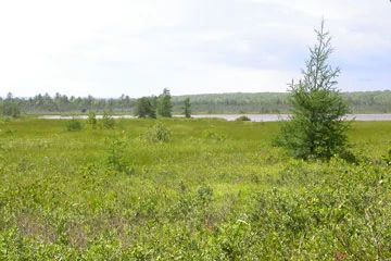
Photo by Drew Feldkirchner
Big Bay Sand Spit and Bog is located on an island in Lake Superior and features a long, curving baymouth bar behind which lies a lagoon, an extensive quaking sphagnum-sedge bog and older sand ridges. The youngest bar is marked by four zones: 1) wet sand beach less than 20 feet wide; 2) dry beach stabilized by several species of beach grasses; 3) rear beach or heath zone sloping away from the beach sand, sparsely wooded with red and white pines in barrens-like openings covered with lichens, bearberry, low juniper, false heather, blueberry and huckleberry; and 4) tall shrub zone bordering the lagoon edge of the sand spit.
The total beach acreage is 34 acres. Vegetation west of the sand spit consists of submerged aquatics in the shallow water and bog shrubs on the many small islands as it grades into the sphagnum-sedge bog. The floating bog contains one of the richest bog floras in the Lake Superior region. Just east of the old ridge is a conifer swamp of white cedar, black and white spruces, and tamarack. The old ridge is second-growth timber. An extensive cordwalk allows visitors to traverse the baymouth bar without disturbing the sensitive vegetation. Big Bay Sand Spit and Bog is owned by the DNR and was designated a State Natural Area in 1980.
Very few State Natural Areas have public facilities, but nearly all are open for a variety of recreational activities as indicated below. Generally, there are no picnic areas, restrooms, or other developments. Parking lots or designated parking areas are noted on individual SNA pages and maps. Trails, if present, are typically undesignated footpaths. If a developed trail is present, it will normally be noted on the SNA map under the Maps tab. A compass and topographic map or a GPS unit are useful tools for exploring larger, isolated SNAs.
The good majority of SNAs are isolated and have few or no facilities. Some SNAs have vehicle access lanes or parking lots, but their accessibility may vary depending on weather conditions. Parking lots and lanes are not plowed during winter. Hiking trails may be nonexistent or consist of undeveloped footpaths. A GPS unit or compass and a detailed topographic map are useful tools for exploring larger SNAs.
Entrance fees: Except for Parfrey's Glen, the Cambrian Outlook in the Dells of the Wisconsin River, SNAs within State Parks and some within State Forests, all other DNR-owned SNAs do not have any admission fees. For more information, see Wis. Admin. Code NR 45. For non-DNR-owned SNAs, we are unaware of any vehicle or admission fees. However, please contact the landowner for more information.
Allowable activities: DNR-owned land
The activities listed below are generally allowed on all DNR-owned SNA lands. Exceptions to this list of public uses, such as SNAs closed to hunting, are noted above and posted with signs on the property site.
- Hiking
- Fishing
- Cross country skiing
- Hunting
- Trapping
- Scientific research (permit required)
- Outdoor education
- Wild edibles (What is this?)
- Pets (Rules)
- Wildlife viewing
Prohibited activities: all SNAs
- Camping and campfires
- Collecting of animals (other than legally harvested species), non-edible fungi, rocks, minerals, fossils, archaeological artifacts, soil, downed wood, or any other natural material alive or dead.
- Collecting for scientific research requires a permit issued by the DNR
- Collecting of plants including seeds, roots or other non-edible parts of herbaceous plants such as wildflowers or grasses
- Geocaching
- Horseback riding
- Rock climbing
- Vehicles, including bicycles, ATVs, aircraft, and snowmobiles except on trails and roadways designated for their use.
For rules governing state-owned SNAs and other state lands, please consult Chapter NR 45 Wis. Admin. Code [exit DNR].
Location
Within Big Bay State Park, Madeline Island, Ashland County. T50N-R2W, Section 19. T50N-R3W, Sections 13, 14, 23, 24. 963 acres.
Driving directions
Take the ferry from Bayfield to Madeline Island. From the ferry landing in La Pointe, turn right into downtown and then left onto Middle Road. In 4 miles, Middle Road changes to Hagen Road and will lead 2 miles to the State Park entrance. Park maps are available at the contact station. A boardwalk leads through the sand spit. A State Park sticker must be displayed on all vehicles entering the park.
The DNR's state natural areas program is comprised of lands owned by the state, private conservation organizations, municipalities, other governmental agencies, educational institutions, and private individuals. While the majority of SNAs are open to the public, access may vary according to individual ownership policies. Public use restrictions may apply due to public safety, or to protect endangered or threatened species or unique natural features. Lands may be temporarily closed due to specific management activities.
Users are encouraged to contact the landowner for more specific details. The data shown on these maps have been obtained from various sources, and are of varying age, reliability, and resolution. The data may contain errors or omissions and should not be interpreted as a legal representation of legal ownership boundaries. To create your custom map where you can zoom to a specific location, please use the DNR's Mapping Application.
Big Bay Sand Spit And Bog is owned by the DNR