Bibon Swamp
No. 275
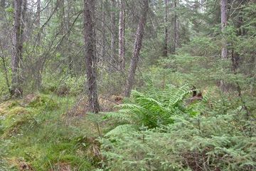
Photo by Drew Feldkirchner
Bibon Swamp, the largest wetland in Bayfield County, occupies the basin of an extinct glacial lake drained by the White River, a hard, cold-water trout stream. The community types of this 15-square-mile lowland are unusually varied for such a topographically uniform basin. Portions are forested with a rich wet-mesic conifer swamp of medium-sized white cedar, although trunk coring revealed that at least parts of the stand are more than 150 years old. Bunchberry, twinflower, small bishop's-cap and several orchid species are representative of the ground layer here. Resident birds include Nashville, parula, and Canada warblers, and winter wrens.
Bordering the cedar swamp is a wet forest dominated by black ash, with a ground layer of speckled alder, sensitive fern, wood nettle and poison ivy. Black and white warblers, veery and red-eyed vireos are common nesting birds. North of the river conditions is very different with a large complex of peatland communities including open bog, spruce-tamarack muskeg and black spruce swamp.
Deep sphagnum hummocks form a continuous ground cover upon which ericaceous shrubs grow including leather-leaf, bog laurel and Labrador-tea. Birds found in these coniferous peatlands include palm warbler, yellow-bellied flycatcher, boreal chickadee and sharp-shinned hawk. Vast shrub swamps composed of slender willow, red-osier dogwood and speckled alder blanket portions of the wetland.
Other communities of lesser areal extent include northern sedge meadow composed of Carex species and blue-joint grass and patches of riparian woodlands, dominated by American elm, green ash and red maple along the White River. Bibon Swamp is owned by the DNR and was designated a State Natural Area in 1992.
Very few State Natural Areas have public facilities, but nearly all are open for a variety of recreational activities as indicated below. Generally, there are no picnic areas, restrooms, or other developments. Parking lots or designated parking areas are noted on individual SNA pages and maps. Trails, if present, are typically undesignated footpaths. If a developed trail is present, it will normally be noted on the SNA map under the Maps tab. A compass and topographic map or a GPS unit are useful tools for exploring larger, isolated SNAs.
The good majority of SNAs are isolated and have few or no facilities. Some SNAs have vehicle access lanes or parking lots, but their accessibility may vary depending on weather conditions. Parking lots and lanes are not plowed during winter. Hiking trails may be nonexistent or consist of undeveloped footpaths. A GPS unit or compass and a detailed topographic map are useful tools for exploring larger SNAs.
Entrance fees: Except for Parfrey's Glen, the Cambrian Outlook in the Dells of the Wisconsin River, SNAs within State Parks and some within State Forests, all other DNR-owned SNAs do not have any admission fees. For more information, see Wis. Admin. Code NR 45. For non-DNR-owned SNAs, we are unaware of any vehicle or admission fees. However, please contact the landowner for more information.
Allowable activities: DNR-owned land
The activities listed below are generally allowed on all DNR-owned SNA lands. Exceptions to this list of public uses, such as SNAs closed to hunting, are noted above and posted with signs on the property site.
- Hiking
- Fishing
- Cross country skiing
- Hunting
- Trapping
- Scientific research (permit required)
- Outdoor education
- Wild edibles (What is this?)
- Pets (Rules)
- Wildlife viewing
Prohibited activities: all SNAs
- Camping and campfires
- Collecting of animals (other than legally harvested species), non-edible fungi, rocks, minerals, fossils, archaeological artifacts, soil, downed wood, or any other natural material alive or dead.
- Collecting for scientific research requires a permit issued by the DNR
- Collecting of plants including seeds, roots or other non-edible parts of herbaceous plants such as wildflowers or grasses
- Geocaching
- Horseback riding
- Rock climbing
- Vehicles, including bicycles, ATVs, aircraft, and snowmobiles except on trails and roadways designated for their use.
For rules governing state-owned SNAs and other state lands, please consult Chapter NR 45 Wis. Admin. Code [exit DNR].
Location
Bayfield County. T45N-R6W, Sections 1-18; T46N-R6W, Sections 29-35. 9,613 acres.
Driving directions
Several places afford access to the site. From U.S. Highway 63, on the east side of Grandview, go north on Raymond Avenue/Taylor Lane into the swamp. Alternatively, go east from Grandview on 63 about 1 mile to Matt's Lane, then north about 0.8 miles to its end. The parking area in the southwest portion of the property is found by traveling north of Hwy 63 on N. Sweden Road for about 1.25 miles, then following Bergeman Lane north to the dead end. Another parking area is located in the northwest portion of the property, approximately .5 miles south of Sutherland Road on Goldberg Rd. The natural area is best seen by canoe. Canoe access via the White River is provided at the junction of Sutherland Road and Mason Delta Road, about 5 miles west of Mason; a canoe take-out and parking area are located about .5 miles west of Hwy 63 on Bibon Road.
The DNR's state natural areas program is comprised of lands owned by the state, private conservation organizations, municipalities, other governmental agencies, educational institutions, and private individuals. While the majority of SNAs are open to the public, access may vary according to individual ownership policies. Public use restrictions may apply due to public safety, or to protect endangered or threatened species or unique natural features. Lands may be temporarily closed due to specific management activities.
Users are encouraged to contact the landowner for more specific details. The data shown on these maps have been obtained from various sources, and are of varying age, reliability, and resolution. The data may contain errors or omissions and should not be interpreted as a legal representation of legal ownership boundaries. To create your custom map where you can zoom to a specific location, please use the DNR's Mapping Application.
Bibon Swamp is owned by the DNR