Beulah Bog
No. 122
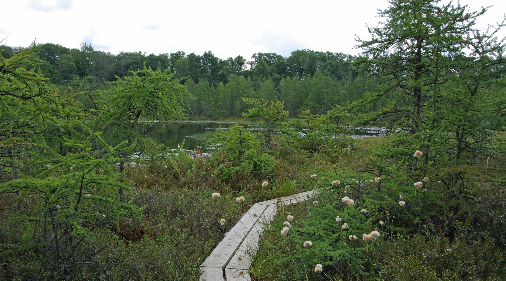
Photo by Thomas A. Meyer/DNR
Beulah Bog lies in a series of four kettle holes and features an undisturbed bog with many unusual plants more typical of northern bogs. Classical stages of ecological succession are exhibited in the bog including a shallow bog lake dominated by water-shield with white and yellow water lilies and extensive floating mud flats; an advancing, quaking sedge and sphagnum mat between 25 and 50 feet wide; a northern wet forest of tamarack and bog shrubs and; a wet open moat surrounding the main bog, dominated by wild calla and cat-tails.
Undisturbed bogs in this area are rare and the site supports several regionally rare plants with more northern affinities including dense cotton grass, large and small cranberry, and small bladderwort. The site harbors six species of insectivorous plants including pitcher plant, sundew and bladderwort. The bog lake provides a habitat for several dragonfly species and other invertebrates. Beulah Bog is owned by the DNR and was designated a State Natural Area in 1975.
Very few State Natural Areas have public facilities, but nearly all are open for a variety of recreational activities as indicated below. Generally, there are no picnic areas, restrooms, or other developments. Parking lots or designated parking areas are noted on individual SNA pages and maps. Trails, if present, are typically undesignated footpaths. If a developed trail is present, it will normally be noted on the SNA map under the Maps tab. A compass and topographic map or a GPS unit are useful tools for exploring larger, isolated SNAs.
The good majority of SNAs are isolated and have few or no facilities. Some SNAs have vehicle access lanes or parking lots, but their accessibility may vary depending on weather conditions. Parking lots and lanes are not plowed during winter. Hiking trails may be nonexistent or consist of undeveloped footpaths. A GPS unit or compass and a detailed topographic map are useful tools for exploring larger SNAs.
Entrance fees: Except for Parfrey's Glen, the Cambrian Outlook in the Dells of the Wisconsin River, SNAs within State Parks and some within State Forests, all other DNR-owned SNAs do not have any admission fees. For more information, see Wis. Admin. Code NR 45. For non-DNR-owned SNAs, we are unaware of any vehicle or admission fees. However, please contact the landowner for more information.
Allowable activities: DNR-owned land
The activities listed below are generally allowed on all DNR-owned SNA lands. Exceptions to this list of public uses, such as SNAs closed to hunting, are noted above and posted with signs on the property site.
- Hiking
- Fishing
- Cross country skiing
- Hunting
- Trapping
- Scientific research (permit required)
- Outdoor education
- Wild edibles (What is this?)
- Pets (Rules)
- Wildlife viewing
Prohibited activities: all SNAs
- Camping and campfires
- Collecting of animals (other than legally harvested species), non-edible fungi, rocks, minerals, fossils, archaeological artifacts, soil, downed wood, or any other natural material alive or dead.
- Collecting for scientific research requires a permit issued by the DNR
- Collecting of plants including seeds, roots or other non-edible parts of herbaceous plants such as wildflowers or grasses
- Geocaching
- Horseback riding
- Rock climbing
- Vehicles, including bicycles, ATVs, aircraft, and snowmobiles except on trails and roadways designated for their use.
For rules governing state-owned SNAs and other state lands, please consult Chapter NR 45 Wis. Admin. Code [exit DNR].
Location
Walworth County. T4N-R18E, Sections 7, 8. 78 acres.
Driving directions
From the intersection of County Highways N and J in Troy Center (4.5 miles northwest of East Troy), go east on J for 2.6 miles, then south on Stringers Bridge Road 0.8 miles to a parking area east of the road. Follow the hiking trail east 0.3 miles through the restored oak opening to the edge of the bog. A boardwalk leads visitors through the bog to the edge of the bog lake.
Please note that in wet years, the boardwalk may be underwater and appropriate footwear will be needed.
The DNR's state natural areas program is comprised of lands owned by the state, private conservation organizations, municipalities, other governmental agencies, educational institutions, and private individuals. While the majority of SNAs are open to the public, access may vary according to individual ownership policies. Public use restrictions may apply due to public safety, or to protect endangered or threatened species or unique natural features. Lands may be temporarily closed due to specific management activities.
Users are encouraged to contact the landowner for more specific details. The data shown on these maps have been obtained from various sources, and are of varying age, reliability, and resolution. The data may contain errors or omissions and should not be interpreted as a legal representation of legal ownership boundaries. To create your custom map where you can zoom to a specific location, please use the DNR's Mapping Application.
Beulah Bog is owned by the DNR