Berg Prairie and Billy Goat Ridge
No. 596
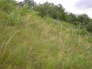
Photo by DNR
Berg Prairie and Billy Goat Ridge contain a mosaic of dry-mesic forest, open oak woodland, and dry prairie openings on the rugged ridge and coulee terrain of Wisconsin's Driftless Area. Located along a ridge top and steep south-facing slope, Berg Prairie is the forest's largest dry prairie remnant with characteristic species including little bluestem, side-oats grama, prairie dropseed, yellow coneflower, silky aster, whorled milkweed, wild bergamot, prairie dropseed and Indian grass. Other small, scattered prairie openings are found within forested areas of this site as well.
Billy Goat Ridge is a complex of small, dry prairie openings and dry cliffs located along a steep east-to-west ridgeline on the northern edge of the Forest. Characteristic plant species include lead plants, short green milkweed, pasqueflower, purple prairie clover and prairie violet. Important grasses are big bluestem, prairie satin grass, little bluestem, side-oats grama and needle grass. The prairie is embedded within a forested area of white oak, bur oak, red oak, black oak, white birch, aspen and shagbark hickory.
Some of the characteristic open oak woodland species are absent due to past grazing and wood species encroachment. However, the presence of some quality understory species, prairie species, and open-grown bur and black oak indicate the potential for savanna and native grassland restoration. Berg Prairie and Billy Goat Ridge is owned by the DNR and was designated a State Natural Area in 2009.
Very few State Natural Areas have public facilities, but nearly all are open for a variety of recreational activities as indicated below. Generally, there are no picnic areas, restrooms, or other developments. Parking lots or designated parking areas are noted on individual SNA pages and maps. Trails, if present, are typically undesignated footpaths. If a developed trail is present, it will normally be noted on the SNA map under the Maps tab. A compass and topographic map or a GPS unit are useful tools for exploring larger, isolated SNAs.
The good majority of SNAs are isolated and have few or no facilities. Some SNAs have vehicle access lanes or parking lots, but their accessibility may vary depending on weather conditions. Parking lots and lanes are not plowed during winter. Hiking trails may be nonexistent or consist of undeveloped footpaths. A GPS unit or compass and a detailed topographic map are useful tools for exploring larger SNAs.
Entrance fees: Except for Parfrey's Glen, the Cambrian Outlook in the Dells of the Wisconsin River, SNAs within State Parks and some within State Forests, all other DNR-owned SNAs do not have any admission fees. For more information, see Wis. Admin. Code NR 45. For non-DNR-owned SNAs, we are unaware of any vehicle or admission fees. However, please contact the landowner for more information.
Allowable activities: DNR-owned land
The activities listed below are generally allowed on all DNR-owned SNA lands. Exceptions to this list of public uses, such as SNAs closed to hunting, are noted on the Directions tab and posted with signs on site.
- Hiking
- Fishing
- Cross country skiing
- Hunting
- Trapping
- Scientific research (permit required)
- Outdoor education
- Wild edibles (What is this?)
- Pets (Rules)
- Wildlife viewing
Prohibited activities: all SNAs
- Camping and campfires
- Collecting of animals (other than legally harvested species), non-edible fungi, rocks, minerals, fossils, archaeological artifacts, soil, downed wood, or any other natural material alive or dead.
- Collecting for scientific research requires a permit issued by the DNR
- Collecting of plants including seeds, roots or other non-edible parts of herbaceous plants such as wildflowers or grasses
- Geocaching
- Horseback riding
- Rock climbing
- Vehicles, including bicycles, ATVs, aircraft, and snowmobiles except on trails and roadways designated for their use.
For rules governing state-owned SNAs and other state lands, please consult Chapter NR 45 Wis. Admin. Code [exit DNR].
Location
Within the Coulee Experimental Forest, La Crosse County. T16N-R5W, Section 18, 29, 30. 92 acres.
Driving directions
For Billy Goat Ridge: From the I-90 and State Highway 62 interchange in Bangor, go south on 62 1.1 miles, then west on Russlan Coulee Road 1.7 miles and park. Walk on the primitive Forest Road (no vehicles) for 0.2 miles, then head north to the site. For Berg Prairie: From the I-90 and State Highway 62 interchange in Bangor, go south on 62 for 1.8 miles, then south and west on County II for 2.4 miles. The site lies south of the road. A small parking area is located on Antony Road 0.4 miles west of its intersection with County II.
The DNR's state natural areas program is comprised of lands owned by the state, private conservation organizations, municipalities, other governmental agencies, educational institutions, and private individuals. While the majority of SNAs are open to the public, access may vary according to individual ownership policies. Public use restrictions may apply due to public safety, or to protect endangered or threatened species or unique natural features. Lands may be temporarily closed due to specific management activities.
Users are encouraged to contact the landowner for more specific details. The data shown on these maps have been obtained from various sources, and are of varying age, reliability, and resolution. The data may contain errors or omissions and should not be interpreted as a legal representation of legal ownership boundaries. To create your custom map where you can zoom to a specific location, please use the DNR's Mapping Application.
Berg Prairie and Billy Goat Ridge is owned by the DNR