Beaver Creek
No. 478
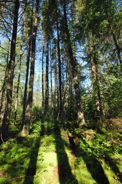
Photo by Josh Mayer
Beaver Creek features high-quality natural communities associated with the Vilas-Oneida Outwash Plains land type including northern dry-mesic forest, northern wet forest and open bog. The mature, fire-related dry-mesic forest is dominated by large red pine, mostly 15-20 inches in diameter although some individuals are larger. The stand's year of origin is 1890. Associates include white pine, red maple and white spruce.
Although not common, there are pockets of white pine regeneration, especially on upland islands within the black spruce swamp forest. The dense shrub and sapling layer is primarily beaked hazelnut, red maple and mountain maple with blueberry and sweet fern. The ground flora is variable and includes barren strawberry, trailing arbutus, early low blueberry, wintergreen, yellow blue bead lily and spinulose wood fern. The lowland northern wet forest is dominated by older black spruce with several small inclusions of white cedar and a fringe of tamarack along the Little Deerskin River.
Bryophytes (sphagnum, feather mosses, liverworts and lichens) are a dominant group in the understory and on branches and trunks of black spruce. Several small spring runs start within the site. Situated within a kettle depression is a small but pristine poor fen surrounding a bog pond. The fen is dominated by white beak-rush and arrow grass with wool grass, few-seeded sedge, two-seeded bog sedge, mud sedge, cotton grass and numerous ericaceous shrubs. Several boreal birds are known to occur here including boreal chickadee and gray jay. Beaver Creek is owned by the U.S. Forest Service and was designated a State Natural Area in 2007.
Very few State Natural Areas have public facilities, but nearly all are open for various recreational activities as indicated below. Generally, there are no picnic areas, restrooms, or other developments. Parking lots or designated parking areas are noted on individual SNA pages and maps. If a developed trail is present, it will normally be noted on the SNA map and/or under the Directions tab. A compass and topographic map or a GPS unit are useful tools for exploring larger, isolated SNAs.
The good majority of SNAs are isolated and have few or no facilities. Some SNAs have vehicle access lanes or parking lots, but their accessibility may vary depending on weather conditions. Parking lots and lanes are not plowed during winter. Hiking trails may be nonexistent or consist of undeveloped footpaths. A GPS unit or compass and a detailed topographic map are useful tools for exploring larger SNAs.
Non-DNR lands
Entrance fees: For non-DNR-owned SNAs, we are unaware of any vehicle or admission fees. However, please contact the landowner for more information.
Hunting and trapping
Other activities
Other allowable activities such as - but not limited to camping, geocaching and bicycling are determined by the landowner. Please contact them directly or visit their websites for details.
Location
Within the Chequamegon-Nicolet National Forest. Vilas County. T41N-R11E, Sections 28-33. 697 acres.
Driving directions
The site is located 6 miles northeast of Eagle River, WI. From Eagle River, go north on Highway 45 for 4 miles, then east on Highway 17 for 7 miles, then south on FR 2178 for about one mile. The site is located south of FR 2178. Further access to the site can be gained using FR 2470 and 2470B.
The DNR's state natural areas program is comprised of lands owned by the state, private conservation organizations, municipalities, other governmental agencies, educational institutions and private individuals. While the majority of SNAs are open to the public, access may vary according to individual ownership policies. Public use restrictions may apply due to public safety, or to protect endangered or threatened species or unique natural features. Lands may be temporarily closed due to specific management activities.
Users are encouraged to contact the landowner for more specific details. The data shown on these maps have been obtained from various sources, and are of varying age, reliability, and resolution. The data may contain errors or omissions and should not be interpreted as a legal representation of legal ownership boundaries. To create your custom map where you can zoom to a specific location, please use the DNR's Mapping Application.
Beaver Creek is owned by the U.S. Forest Service