Bearsdale Creek & Hyatt Springs
No. 471
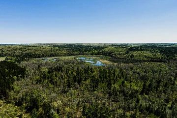
Photo by Aaron Carlson
Bearsdale Creek and Hyatt Springs is a diverse site with several excellent representative natural communities as well as numerous unique natural features. Two key aspects are its spring runs and ponds and rich bottomland hardwood forest. The spring runs and ponds (including Hyatt springs, Shunenberg Creek and Bearsdale Creek) are small, hard-water and landlocked. They emanate from springs and flow in a westerly direction, then disappear in the fine sands. All support small populations of minnows and brook trout.
The site supports a unique wet-mesic forest grading into a hardwood swamp dominated by bur oak, basswood and black ash with numerous plant species more common in rich bottomland forests to the south. Bearsdale Creek passes through the stand and might act as its flood source contributing rich alluvial soils. An upland northern mesic forest is dominated by bur oak and basswood with sugar maple, green ash and black cherry. A very rich, diverse understory includes wood nettle, wild leek, bloodroot, bottlebrush grass, ostrich fern and American starflower.
The northern hardwood swamp is a unique community dominated by black ash, bur oak and box elder with a thick understory of prickly ash, hawthorne and hops. The site is seasonally flooded with a diverse herbaceous layer and inclusions of sedge meadow. Situated on rough knobs and kettle topography is a mature, second-growth dry-mesic forest dominated by medium-sized red pine and white pine. Canopy associates include red maple, red oak, paper birch, big-tooth aspen, black cherry and balsam fir.
Pine reproduction is generally sparse, though pockets of sapling white pine occur. Most of the reproducing trees are hardwoods. The shrub layer is moderate to dense with beaked hazelnut, serviceberry and Rubus spp. Characteristic herbs include bracken fern, winterberry, large-leaved aster, early low blueberry, velvet-leaf blueberry, narrow-leaved cow-wheat and lycopods. There has been little to no disturbance in this stand since the cut-over logging era, probably about 80-100 years ago. Bearsdale Creek and Hyatt Springs are owned by the U.S. Forest Service and were designated a State Natural Area in 2007. This site is also recognized by the Forest Service as an established Research Natural Area.
Very few State Natural Areas have public facilities, but nearly all are open for a variety of recreational activities as indicated below. Generally, there are no picnic areas, restrooms, or other developments. Parking lots or designated parking areas are noted on individual SNA pages and maps. Trails, if present, are typically undesignated footpaths.If a developed trail is present, it will normally be noted on the SNA map and/or under the Directions tab. A compass and topographic map or a GPS unit are useful tools for exploring larger, isolated SNAs.
The good majority of SNAs are isolated and have few or no facilities. Some SNAs have vehicle access lanes or parking lots, but their accessibility may vary depending on weather conditions. Parking lots and lanes are not plowed during winter. Hiking trails may be nonexistent or consist of undeveloped footpaths. A GPS unit or compass and a detailed topographic map are useful tools for exploring larger SNAs.
Non-DNR lands
Entrance fees: For non-DNR-owned SNAs, we are unaware of any vehicle or admission fees. However, please contact the landowner for more information.
Hunting and trapping
Other activities
Other allowable activities such as - but not limited to camping, geocaching and bicycling are determined by the landowner. Please contact them directly or visit their websites for details.
Location
Within the Chequamegon-Nicolet National Forest. Bayfield County. T44N-R8W, Sections 4-9. 1,005 acres.
Driving directions
From the intersection of Highway 63 and N in Drummond, go west on N for approximately 5.2 miles, then south on FR 803 about 2 miles to the northwest corner of the site.
The DNR's state natural areas program is comprised of lands owned by the state, private conservation organizations, municipalities, other governmental agencies, educational institutions, and private individuals. While the majority of SNAs are open to the public, access may vary according to individual ownership policies. Public use restrictions may apply due to public safety, or to protect endangered or threatened species or unique natural features. Lands may be temporarily closed due to specific management activities.
Users are encouraged to contact the landowner for more specific details. The data shown on these maps have been obtained from various sources, and are of varying age, reliability, and resolution. The data may contain errors or omissions and should not be interpreted as a legal representation of legal ownership boundaries. To create your custom map where you can zoom to a specific location, please use the DNR's Mapping Application.
Bearsdale Creek & Hyatt Springs is owned by The US Forest Service