Bear Creek Sedge Meadow
No. 369
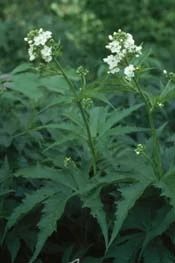
Photo by K. Kohout
Bear Creek Sedge Meadow contains two separate parcels--both sedge meadow communities with Bear Creek flowing through them. Also present is some shallow marsh along the creek. Both are recovering well from past grazing. Sedges are dominant and forbs are present in higher-than-normal densities. Cat-tail and bulrush are found in the wettest areas while the highest ground supports wet prairie vegetation.
A midwestern endemic plant is present along the creek. Other plants include blue-joint grass, sweet Indian plantain, swamp aster, marsh marigold, swamp thistle, boneset, bottle gentian, mountain mint, and cup plant. Breeding birds include wood duck, sandhill crane, belted kingfisher, alder flycatcher, willow flycatcher, sedge and marsh wren, common yellowthroat, and swamp sparrow. Clean water flows through the meadows suggesting the possibility of groundwater seepage. Bear Creek Sedge Meadow is owned by the DNR and was designated a State Natural Area in 2002.
Very few State Natural Areas have public facilities, but nearly all are open for a variety of recreational activities as indicated below. Generally, there are no picnic areas, restrooms, or other developments. Parking lots or designated parking areas are noted on individual SNA pages and maps. Trails, if present, are typically undesignated footpaths. If a developed trail is present, it will normally be noted on the SNA map under the Maps tab. A compass and topographic map or a GPS unit are useful tools for exploring larger, isolated SNAs.
The good majority of SNAs are isolated and have few or no facilities. Some SNAs have vehicle access lanes or parking lots, but their accessibility may vary depending on weather conditions. Parking lots and lanes are not plowed during winter. Hiking trails may be nonexistent or consist of undeveloped footpaths. A GPS unit or compass and a detailed topographic map are useful tools for exploring larger SNAs.
Entrance fees: Except for Parfrey's Glen, the Cambrian Outlook in the Dells of the Wisconsin River, SNAs within State Parks and some within State Forests, all other DNR-owned SNAs do not have any admission fees. For more information, see Wis. Admin. Code NR 45. For non-DNR-owned SNAs, we are unaware of any vehicle or admission fees. However, please contact the landowner for more information.
Allowable activities: DNR-owned land
The activities listed below are generally allowed on all DNR-owned SNA lands. Exceptions to this list of public uses, such as SNAs closed to hunting, are noted above and posted with signs on the property site.
- Hiking
- Fishing
- Cross country skiing
- Hunting
- Trapping
- Scientific research (permit required)
- Outdoor education
- Wild edibles (What is this?)
- Pets (Rules)
- Wildlife viewing
Prohibited activities: all SNAs
- Camping and campfires
- Collecting of animals (other than legally harvested species), non-edible fungi, rocks, minerals, fossils, archaeological artifacts, soil, downed wood, or any other natural material alive or dead.
- Collecting for scientific research requires a permit issued by the DNR
- Collecting of plants including seeds, roots or other non-edible parts of herbaceous plants such as wildflowers or grasses
- Geocaching
- Horseback riding
- Rock climbing
- Vehicles, including bicycles, ATVs, aircraft, and snowmobiles except on trails and roadways designated for their use.
For rules governing state-owned SNAs and other state lands, please consult Chapter NR 45 Wis. Admin. Code [exit DNR].
Location
Within Bear Creek Fishery Area, Richland & Sauk County. T9N-R2E, Section 1. T10N-R3E, Sections 19, 20. 80 acres.
Driving directions
From Lone Rock, go north on 130 for 6 miles, then east on Brown Church Road for 1.2 miles. The first parcel lies just west of the road. To reach the second area, from the junction of 130 and Brown Church Road, continue north on 130 4.6 miles to the intersection with Highway N-east and park along N. The site lies southeast of the road.
The DNR's state natural areas program is comprised of lands owned by the state, private conservation organizations, municipalities, other governmental agencies, educational institutions, and private individuals. While the majority of SNAs are open to the public, access may vary according to individual ownership policies. Public use restrictions may apply due to public safety, or to protect endangered or threatened species or unique natural features. Lands may be temporarily closed due to specific management activities.
Users are encouraged to contact the landowner for more specific details. The data shown on these maps have been obtained from various sources, and are of varying age, reliability, and resolution. The data may contain errors or omissions and should not be interpreted as a legal representation of legal ownership boundaries. To create your custom map where you can zoom to a specific location, please use the DNR's Mapping Application.
Bear Creek Sedge Meadow is owned by: Wisconsin DNR