Bear Caves
No. 286
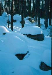
Photo by Thomas A. Meyer/DNR
Bear Caves State Natural Area is an outstanding geologic feature composed of a boulder train with a complex maze of ridges that contains a diverse lichen and bryophyte community. Located between the Chippewa and Green Bay Lobes of the Wisconsin Glacier, the constant movement and jousting between these two lobes may have resulted in fierce runoff causing a concentration of material to be deposited in the maze of ridges that we see today. Formed from pitted gravel outwash and flanked by several swamps, the southern portion has steep slopes with large, very well-rounded boulders of pink granitic gneiss piled up on the steep esker-like ridges.
The glacial ice and runoff that transported them to the site shaped the round boulders, which average about 4-6 feet in diameter. They are the largest rocks known in Wisconsin to have been concentrated by glacial action. The northern portion is now forested with second-growth sugar maple, birch, and aspen while the southern area is covered with hemlock, sugar maple, and yellow birch. The entire area is covered with a rich blanket of ground vegetation and the boulder train along the southern edge encloses a small sphagnum-tamarack bog. The name "bear caves" stems from a local legend that maintains that bears live in the small "caves" found scattered through the boulder train. Bear Caves is owned by Langlade County and was designated a State Natural Area in 1995.
Very few State Natural Areas have public facilities, but nearly all are open for a variety of recreational activities as indicated below. Generally, there are no picnic areas, restrooms, or other developments. Parking lots or designated parking areas are noted on individual SNA pages and maps. Trails, if present, are typically undesignated footpaths. If a developed trail is present, it will normally be noted on the SNA map under the Maps tab. A compass and topographic map or a GPS unit are useful tools for exploring larger, isolated SNAs.
The good majority of SNAs are isolated and have few or no facilities. Some SNAs have vehicle access lanes or parking lots, but their accessibility may vary depending on weather conditions. Parking lots and lanes are not plowed during winter. Hiking trails may be nonexistent or consist of undeveloped footpaths. A GPS unit or compass and a detailed topographic map are useful tools for exploring larger SNAs.
Entrance fees: Except for Parfrey's Glen, the Cambrian Outlook in the Dells of the Wisconsin River, SNAs within State Parks and some within State Forests, all other DNR-owned SNAs do not have any admission fees. For more information, see Wis. Admin. Code NR 45 [exit DNR]. For non-DNR-owned SNAs, we are unaware of any vehicle or admission fees. However, please contact the landowner for more information.
Allowable activities: DNR-owned land
The activities listed below are generally allowed on all DNR-owned SNA lands. Exceptions to this list of public uses, such as SNAs closed to hunting, are noted above and posted with signs on the property site.
- Hiking
- Fishing
- Cross country skiing
- Hunting
- Trapping
- Scientific research (permit required [PDF])
- Outdoor education
- Wild edibles (What is this?)
- Pets (Rules)
- Wildlife viewing
Prohibited activities: all SNAs
- Camping and campfires
- Collecting of animals (other than legally harvested species), non-edible fungi, rocks, minerals, fossils, archaeological artifacts, soil, downed wood, or any other natural material alive or dead.
- Collecting for scientific research requires a permit issued by the DNR
- Collecting of plants including seeds, roots or other non-edible parts of herbaceous plants such as wildflowers or grasses
- Geocaching
- Horseback riding
- Rock climbing
- Vehicles, including bicycles, ATVs, aircraft, and snowmobiles except on trails and roadways designated for their use.
For rules governing state-owned SNAs and other state lands, please consult Chapter NR 45 Wis. Admin. Code [exit DNR].
Location
Within Langlade County Forest. Langlade County. T32N-R14E, Section 29. 50 acres.
Driving directions
From the intersection of State Highways 64 and 55 in Langlade, go north on 55 for 3.5 miles to a town road on the east and an unimproved access road on the west. Park at the town road/highway intersection and walk west along the unimproved access road 0.2 miles. The site lies north and south of the road. Disregard any "private road" signs as this is legal public access.
The DNR's state natural areas program is comprised of lands owned by the state, private conservation organizations, municipalities, other governmental agencies, educational institutions, and private individuals. While the majority of SNAs are open to the public, access may vary according to individual ownership policies. Public use restrictions may apply due to public safety, or to protect endangered or threatened species or unique natural features. Lands may be temporarily closed due to specific management activities.
Users are encouraged to contact the landowner for more specific details. The data shown on these maps have been obtained from various sources, and are of varying age, reliability, and resolution. The data may contain errors or omissions and should not be interpreted as a legal representation of legal ownership boundaries. To create your custom map where you can zoom to a specific location, please use the DNR's Mapping Application.
Bear Caves is owned by: Langlade County