Bauer Brockway Barrens
No. 325
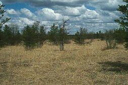
Photo by Thomas A. Meyer/DNR
Bauer-Brockway Barrens features scattered jack pine and Hill’s oak within a matrix of sand prairie and shrubs located on the level sandy soils characteristic of the extinct Glacial Lake Wisconsin. American hazelnut and New Jersey Tea dominate the shrub layer while sand prairie species dominate the understory with little blue-stem, June grass, western sunflower, bastard-toadflax, cream wild indigo, flowering spurge, yellow flax, pale-spike lobelia, sand primrose, and bird’s-foot violet. Composites are especially diverse with five asters, four species of goldenrod, and three species of blazing star. The site has a diverse butterfly component including one of the most diverse moth fauna of any other barrens in the state. Several rare and uncommon lepidopterans are supported here. Indian Grave Creek runs northwest-southeast through the barrens adding to the overall site diversity. Bauer-Brockway Barrens is owned by the DNR and Jackson County and was designated a state natural area in 1997.
Very few State Natural Areas have public facilities, but nearly all are open for a variety of recreational activities as indicated below. Generally, there are no picnic areas, restrooms, or other developments. Parking lots or designated parking areas are noted on individual SNA pages and maps. Trails, if present, are typically undesignated footpaths. If a developed trail is present, it will normally be noted on the SNA map under the Maps tab. A compass and topographic map or a GPS unit are useful tools for exploring larger, isolated SNAs.
The good majority of SNAs are isolated and have few or no facilities. Some SNAs have vehicle access lanes or parking lots, but their accessibility may vary depending on weather conditions. Parking lots and lanes are not plowed during winter. Hiking trails may be nonexistent or consist of undeveloped footpaths. A GPS unit or compass and a detailed topographic map are useful tools for exploring larger SNAs.
Hunting and trapping
This SNA has multiple landowners: Opportunities for hunting and trapping depend on the landowner. In general, most DNR-owned land allows hunting and trapping. Partner-owned land may have other rules (for example, university-owned lands do not allow hunting or trapping). Please contact them directly to find out about their rules for hunting and trapping. You can find a link to other owner websites under the Resources tab.
NOTE: Per state regulations, hunting is allowed on the DNR-owned SNA lands. However, on lands located within the Village of Rock Springs (see map), the discharge of firearms is prohibited within the village limits. See their Village Ordinance Chapter 4 [exit DNR] for details.
Allowable activities: DNR-owned land
The activities listed below are generally allowed on all DNR-owned SNA lands. Exceptions to this list of public uses, such as SNAs closed to hunting, are noted under the "Access" tab above and posted with signs on site.
- Hiking
- Fishing
- Cross country skiing
- Hunting
- Trapping
- Scientific research (permit required)
- Outdoor education
- Wild edibles (What is this?)
- Pets (Rules)
- Wildlife viewing
Prohibited activities: all SNAs
- Camping and campfires
- Collecting of animals (other than legally harvested species), non-edible fungi, rocks, minerals, fossils, archaeological artifacts, soil, downed wood, or any other natural material, alive or dead.
- Collecting for scientific research requires a permit issued by the DNR
- Collecting of plants including seeds, roots or other non-edible parts of herbaceous plants such as wildflowers or grasses
- Geocaching
- Horseback riding
- Rock climbing
- Vehicles, including bicycles, ATVs, aircraft, and snowmobiles except on trails and roadways designated for their use.
For rules governing state-owned SNAs and other state lands, please consult Chapter NR 45 Wis. Admin. Code [exit DNR].
Location
Jackson County. T21N-R3W, Section 16. 320 acres.
Driving directions
From the intersection of Highways 94 and 54 in Black River Falls, go east on 54 for 0.4 miles, then east on West Bauer Road for 3.8 miles, then north on Brockway Road for 0.2 miles to a parking area east of the road.
The DNR's state natural areas program is comprised of lands owned by the state, private conservation organizations, municipalities, other governmental agencies, educational institutions, and private individuals. While the majority of SNAs are open to the public, access may vary according to individual ownership policies. Public use restrictions may apply due to public safety, or to protect endangered or threatened species or unique natural features. Lands may be temporarily closed due to specific management activities.
Users are encouraged to contact the landowner for more specific details. The data shown on these maps have been obtained from various sources, and are of varying age, reliability, and resolution. The data may contain errors or omissions and should not be interpreted as a legal representation of legal ownership boundaries. To create your custom map where you can zoom to a specific location, please use the DNR's Mapping Application.
Bauer Brockway Barrens is owned by:
- Jackson County
- Wisconsin DNR