Battle Creek Hemlocks
No. 497
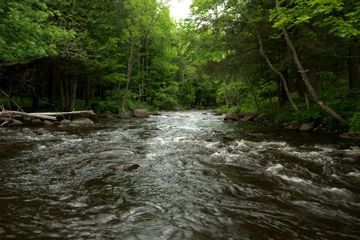
Photo by Josh Mayer
Situated on hilly terrain along the North Branch of the Oconto River, Battle Creek Hemlocks features a northern mesic forest of large hemlock and super-canopy white pine. Canopy associates include white cedar, yellow birch, sugar maple, red oak, and beech. Small maples are frequent and there is a diverse representation of size-age classes among the canopy trees.
The community has a very sparse mid-story and shrub layer but a relatively diverse herbaceous layer including downy yellow violet, large-flowered trillium, baneberry, rosy twisted stalk, and intermediate wood fern. Understory shrubs include American fly honeysuckle and hazel. Canopy gaps, snags, den trees, and coarse woody debris are uncommon here despite the large-diameter trees.
At the base of a steep-sided esker is a small spring-fed trout stream bordered by a northern wet-mesic forest. Medium to large diameter white cedar (8-20 inches) and smaller black ash form a closed canopy over the stream. Large amounts of coarse woody debris are both in the stream and on its banks. The herbaceous layer includes mountain wood sorrel, small white violet, small enchanter's-nightshade, bunchberry, crested shield fern, common oak fern, northern tree club moss, and abundant mosses.
The North Branch of the Oconto River is a hard-water stream having slightly alkaline water. The entire stream is classed as trout water with brook, brown, and rainbow trout inhabiting the waters. Numerous warblers use the forest including blackburnian, black-throated green, black and white, ovenbird, and northern parula. Battle Creek Hemlocks is owned by the U.S. Forest Service and was designated a State Natural Area in 2007. This site is also recognized by the Forest Service as an established Research Natural Area.
Very few State Natural Areas have public facilities, but nearly all are open for a variety of recreational activities as indicated below. Generally, there are no picnic areas, restrooms, or other developments. Parking lots or designated parking areas are noted on individual SNA pages and maps. Trails, if present, are typically undesignated footpaths. If a developed trail is present, it will normally be noted on the SNA map under the Maps tab. A compass and topographic map or a GPS unit are useful tools for exploring larger, isolated SNAs.
The good majority of SNAs are isolated and have few or no facilities. Some SNAs have vehicle access lanes or parking lots, but their accessibility may vary depending on weather conditions. Parking lots and lanes are not plowed during winter. Hiking trails may be nonexistent or consist of undeveloped footpaths. A GPS unit or compass and a detailed topographic map are useful tools for exploring larger SNAs.
Non-DNR lands
Entrance fees: For non-DNR-owned SNAs, we are unaware of any vehicle or admission fees. However, please contact the landowner for more information.
Hunting and trapping
Other activities
Other allowable activities such as - but not limited to camping, geocaching and bicycling are determined by the landowner. Please contact them directly or visit their websites for details.
Location
Within the Chequamegon-Nicolet National Forest. Oconto County. T33N-R16E, Sections 11, 14. 99 acres.
Driving directions
The site is located 4.5 miles northeast of Lakewood, Wisconsin. From Lakewood, go east and north on County F about 4.5 miles to an un-named gravel road on the west side of the highway. Go west and travel less than 0.5 miles to a gated snowmobile trail. The trail leads to the site.
The DNR's state natural areas program is comprised of lands owned by the state, private conservation organizations, municipalities, other governmental agencies, educational institutions and private individuals. While the majority of SNAs are open to the public, access may vary according to individual ownership policies. Public use restrictions may apply due to public safety, or to protect endangered or threatened species or unique natural features. Lands may be temporarily closed due to specific management activities.
Users are encouraged to contact the landowner for more specific details. The data shown on these maps have been obtained from various sources, and are of varying age, reliability, and resolution. The data may contain errors or omissions and should not be interpreted as a legal representation of legal ownership boundaries. To create your custom map where you can zoom to a specific location, please use the DNR's Mapping Application.
Barksdale Ponds is owned by:
- US Forest Service