Battle Bluff Prairie
No. 177
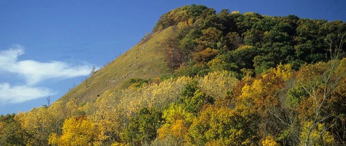
Photo by Thomas A. Meyer/DNR
Location
Vernon County. T11N-R7W, Section 2, 3, 4, 10. 338 acres.
Overview
Battle Bluff Prairie, the site of one of the Black Hawk War battles contains southern dry forest and a south-facing dry prairie on a steep slope. The diverse prairie flora is interspersed with limestone boulders, sandstone outcrops, and a few stunted trees. More than 80 species of native prairie plants have been identified. Grasses include big and little blue-stem, side-oats grama, hairy grama,
Canada wild-rye, and needle grass. Forbs include lyre-leaved rock-cress, butterfly milkweed, Illinois tick-trefoil, northern bedstraw, yellow-star grass, wild bergamot, rough blazing-star, prairie phlox, and bird's-foot violet. On the top and at the bottom the prairie gives way to a forest dominated by oaks, birch, and basswood. The wind-eroded sandstone outcrops and limestone boulders contain several unusual plants such as cliff brake and Canada yew.
The bluff rises some 480 feet to the top where one has a clear view for many miles to the south across the Mississippi River. The rapid warming of the steep, south-facing slope forms convective thermals that are well-known and used by migrating diurnal raptors. Battle Bluff Prairie is owned by the DNR and was designated a State Natural Area in 1983.
Very few State Natural Areas have public facilities, but nearly all are open for a variety of recreational activities as indicated below. Generally, there are no picnic areas, restrooms, or other developments. Parking lots or designated parking areas are noted on individual SNA pages and maps. Trails, if present, are typically undesignated footpaths. If a developed trail is present, it will normally be noted on the SNA map and/or under the "Access" tab. A compass and topographic map or a GPS unit are useful tools for exploring larger, isolated SNAs.
The good majority of SNAs are isolated and have few or no facilities. Some SNAs have vehicle access lanes or parking lots, but their accessibility may vary depending on weather conditions. Parking lots and lanes are not plowed during winter. Hiking trails may be nonexistent or consist of undeveloped footpaths. A GPS unit or compass and a detailed topographic map are useful tools for exploring larger SNAs.
Entrance fees: Excepting Parfrey's Glen, the Cambrian Outlook in the Dells of the Wisconsin River, SNAs within State Parks and some within State Forests, all other DNR-owned SNAs do not have any admission fees. For more information, see Wis. Admin. Code NR 45. For non-DNR-owned SNAs, we are unaware of any vehicle or admission fees. However, please contact the landowner for more information.
ALLOWABLE ACTIVITIES: DNR-OWNED LAND
The activities listed below are generally allowed on all DNR-owned SNA lands. Exceptions to this list of public uses, such as SNAs closed to hunting, are noted above and posted with signs on the property site.
- Hiking
- Fishing
- Cross country skiing
- Hunting
- Trapping
- Scientific research (permit required)
- Outdoor education
- Wild edibles (What is this?)
- Pets (Rules)
- Wildlife viewing
PROHIBITED ACTIVITIES: ALL SNAS
- Camping and campfires
- Collecting of animals (other than legally harvested species), non-edible fungi, rocks, minerals, fossils, archaeological artifacts, soil, downed wood, or any other natural material, alive or dead.
- Collecting for scientific research requires a permit issued by the DNR
- Collecting of plants including seeds, roots or other non-edible parts of herbaceous plants such as wildflowers or grasses
- Geocaching
- Horseback riding
- Rock climbing
- Vehicles, including bicycles, ATVs, aircraft, and snowmobiles except on trails and roadways designated for their use.
For rules governing state-owned SNAs and other state lands, please consult Chapter NR 45 Wis. Admin. Code [exit DNR].
Driving directions
To access the northern bluff prairie, from the junction of Highways 82 and 35 in DeSoto, go north on 35 for 2.7 miles, then east on Battle Hollow Road for 0.25 miles. Park along the road and walk north. To access the southern bluff prairie, continue another 0.3 miles on Battle Hollow Road. Park along the road and walk southeast up the slope. Please remain on the signed DNR land.
The DNR's state natural areas program is comprised of lands owned by the state, private conservation organizations, municipalities, other governmental agencies, educational institutions and private individuals. While the majority of SNAs are open to the public, access may vary according to individual ownership policies. Public use restrictions may apply due to public safety, or to protect endangered or threatened species or unique natural features. Lands may be temporarily closed due to specific management activities.
Users are encouraged to contact the landowner for more specific details. The data shown on these maps have been obtained from various sources, and are of varying age, reliability, and resolution. The data may contain errors or omissions and should not be interpreted as a legal representation of legal ownership boundaries. To create your custom map where you can zoom to a specific location, please use the DNR's Mapping Application.
Battle Bluff Prairie is owned by: Wisconsin DNR