Bastile Lake
No. 302
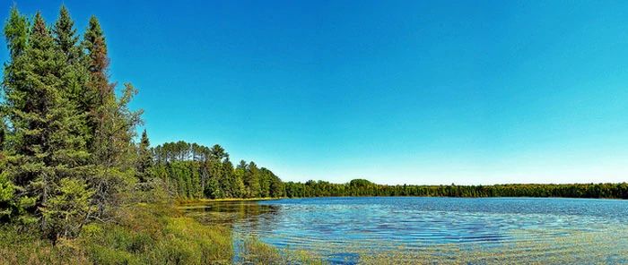
Photo by Aaron Carlson
Bastile Lake State Natural Area features an undeveloped wilderness lake surrounded by a conifer swamp and a narrow stand of mature hemlock. The 47-acre lake is deep and has extremely soft water. The sparse aquatic vegetation includes pipewort, quillwort, and pond lilies.
The fish population is dominated by yellow perch with pumpkinseed, black bullhead, common shiner, and golden shiner. Surrounding the south shore of the lake is a small stand of large old hemlocks with sugar maple, basswood, paper birch, white spruce, white pine, and red pine. The understory includes bunchberry, wood sorrel, and numerous club mosses. White cedar and red maple are common along the shore.
East of the lake is a boggy conifer swamp dominated by black spruce and tamarack and an understory of sphagnum moss, Labrador tea, leather-leaf, small cranberry, blue-joint grass, and sedges. The secluded nature of the lake and sufficient forage fish make the lake suitable habitat for nesting common loons. Other birds include belted kingfisher, black-throated green and Nashville warbler, red-eyed vireo, and brown creeper. Bastile Lake is owned by the USDA Forest Service and was designated a State Natural Area in 1996.
Very few State Natural Areas have public facilities, but nearly all are open for a variety of recreational activities as indicated below. Generally, there are no picnic areas, restrooms, or other developments. Parking lots or designated parking areas are noted on individual SNA pages and maps. Trails, if present, are typically undesignated footpaths. If a developed trail is present, it will normally be noted on the SNA map under the Maps tab. A compass and topographic map or a GPS unit are useful tools for exploring larger, isolated SNAs.
The good majority of SNAs are isolated and have few or no facilities. Some SNAs have vehicle access lanes or parking lots, but their accessibility may vary depending on weather conditions. Parking lots and lanes are not plowed during winter. Hiking trails may be nonexistent or consist of undeveloped footpaths. A GPS unit or compass and a detailed topographic map are useful tools for exploring larger SNAs.
Non-DNR lands
Entrance fees: For non-DNR-owned SNAs, we are unaware of any vehicle or admission fees. However, please contact the landowner for more information.
Hunting and trapping
Other activities
Other allowable activities such as - but not limited to camping, geocaching and bicycling are determined by the landowner. Please contact them directly or visit their websites for details.
Location
Within the Chequamegon-Nicolet National Forest, Forest County. T39N-R14E, Section 28. 156 acres.
Driving directions
From the intersection of State Highway 139 and Settlement Road in Long Lake in western Florence County, go northwest on Settlement Road for 0.2 miles, then west on FR 2168 (Long Lake Road) for 3.7 miles, then south on FR 2167 (Macarther Pine Road) 1.9 miles to an old logging road. Walk east 0.25 miles to the lake.
The DNR's state natural areas program is comprised of lands owned by the state, private conservation organizations, municipalities, other governmental agencies, educational institutions and private individuals. While the majority of SNAs are open to the public, access may vary according to individual ownership policies. Public use restrictions may apply due to public safety, or to protect endangered or threatened species or unique natural features. Lands may be temporarily closed due to specific management activities.
Users are encouraged to contact the landowner for more specific details. The data shown on these maps have been obtained from various sources, and are of varying age, reliability, and resolution. The data may contain errors or omissions and should not be interpreted as a legal representation of legal ownership boundaries. To create your custom map where you can zoom to a specific location, please use the DNR's Mapping Application.
Bastile Lake is owned by:
- US Forest Service