Bass Lake Peatlands
No. 646
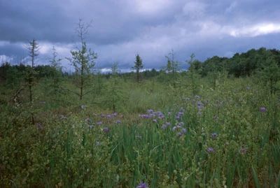
Photo by Andrew Galvin
Bass Lake Peatlands is a vast, open peatland with scattered trees and drains to the southwest from Bass Lake and beyond where it forms the headwaters of Little Connor Creek. Hummocks of sphagnum mosses form a continuous carpet that supports a scattering of stunted black spruce and tamarack and ericaceous shrubs including bog laurel, leather-leaf, and Labrador-tea. Other species present include few-flowered sedge, few-seeded sedge, cotton grass-grass, narrow-leaved cotton-grass, round-leaved sundew, and pitcher plant.
Areas with more nutrient-rich waters support species such as swamp loosestrife, swamp candles, river horsetail, wild calla, bog birch, crested shield fern, and bogbean. Bass Lake is a deep, 94-acre soft-water seepage lake with clear water. Specialized aquatic plants from the "sterile rosette" group are present. These small, stiff-leaved plants hug the lake bottom and can absorb CO2 from the sediment through their roots.
Boggy wetlands and mature second-growth hemlock-white pine forests surround the lake. Richer stands of northern mesic forest dominated by sugar maple, basswood, and white ash are located further from shore. As with many areas in the Forest and around the state, deer browse is heavy and in most places hemlock regeneration is limited to tiny seedlings. Birds include the Nashville warbler, yellow-rumped warbler, palm warbler, Lincoln's sparrow, cedar waxwing, yellow-bellied flycatcher, gray jay, common loon, and bald eagle. Bass Lake Peatlands is owned by the DNR and was designated a State Natural Area in 2010.
Very few State Natural Areas have public facilities, but nearly all are open for a variety of recreational activities as indicated below. Generally, there are no picnic areas, restrooms, or other developments. Parking lots or designated parking areas are noted on individual SNA pages and maps. Trails, if present, are typically undesignated footpaths. If a developed trail is present, it will normally be noted on the SNA map under the Maps tab. A compass and topographic map or a GPS unit are useful tools for exploring larger, isolated SNAs.
The good majority of SNAs are isolated and have few or no facilities. Some SNAs have vehicle access lanes or parking lots, but their accessibility may vary depending on weather conditions. Parking lots and lanes are not plowed during winter. Hiking trails may be nonexistent or consist of undeveloped footpaths. A GPS unit or compass and a detailed topographic map are useful tools for exploring larger SNAs.
Entrance fees: Except for Parfrey's Glen, the Cambrian Outlook in the Dells of the Wisconsin River, SNAs within State Parks and some within State Forests, all other DNR-owned SNAs do not have any admission fees. For more information, see Wis. Admin. Code NR 45. For non-DNR-owned SNAs, we are unaware of any vehicle or admission fees. However, please contact the landowner for more information.
Allowable activities: DNR-owned land
The activities listed below are generally allowed on all DNR-owned SNA lands. Exceptions to this list of public uses, such as SNAs closed to hunting, are noted above and posted with signs on the property site.
- Hiking
- Fishing
- Cross country skiing
- Hunting
- Trapping
- Scientific research (permit required)
- Outdoor education
- Wild edibles (What is this?)
- Pets (Rules)
- Wildlife viewing
Prohibited activities: all SNAs
- Camping and campfires
- Collecting of animals (other than legally harvested species), non-edible fungi, rocks, minerals, fossils, archaeological artifacts, soil, downed wood, or any other natural material, alive or dead.
- Collecting for scientific research requires a permit issued by the DNR
- Collecting of plants including seeds, roots or other non-edible parts of herbaceous plants such as wildflowers or grasses
- Geocaching
- Horseback riding
- Rock climbing
- Vehicles, including bicycles, ATVs, aircraft, and snowmobiles except on trails and roadways designated for their use.
For rules governing state-owned SNAs and other state lands, please consult Chapter NR 45 Wis. Admin. Code [exit DNR].
Location
Within the Flambeau River State Forest, Sawyer and Price Counties. T38N-R2W, Sections 18, 19. T38N-R3W, Sections 13, 24. 921 acres.
Driving directions
From the junction of Highway 13 and County W (Beebe Street) in Phillips, go west on County Highfor way W 18.8 miles, then north on Tower Hill Road 1 mile. Walk east across state forest lands 1 mile into the site.
The DNR's state natural areas program is comprised of lands owned by the state, private conservation organizations, municipalities, other governmental agencies, educational institutions and private individuals. While the majority of SNAs are open to the public, access may vary according to individual ownership policies. Public use restrictions may apply due to public safety, or to protect endangered or threatened species or unique natural features. Lands may be temporarily closed due to specific management activities.
Users are encouraged to contact the landowner for more specific details. The data shown on these maps have been obtained from various sources, and are of varying age, reliability, and resolution. The data may contain errors or omissions and should not be interpreted as a legal representation of legal ownership boundaries. To create your custom map where you can zoom to a specific location, please use the DNR's Mapping Application.
Aurora Lake is owned by: Wisconsin DNR