Bass Hollow
No. 270
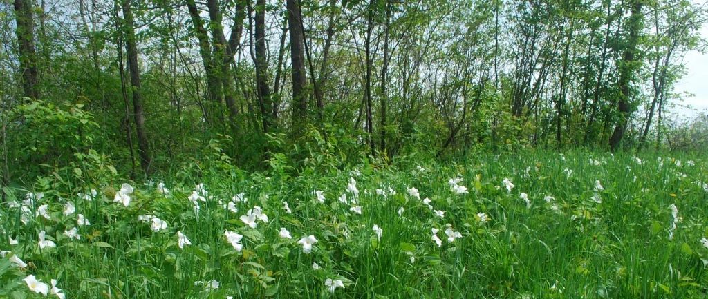
Photo by Josh Mayer
Located in a deep, cliff-lined coulee, Bass Hollow contains an undisturbed forested gorge of mesic hardwoods with sugar maple, basswood, and red oak. Other trees include yellow birch and black ash found in springy areas. Hemlock occupies north-facing cliffs. This site features one of the largest blocks of undisturbed southern mesic forest in the state. The topography is very steep with sandstone cliffs rising over 100 feet high in some places.
The upper slopes and ridge tops support a dry to the dry-mesic forest of red and white oaks, big-tooth aspen, and black cherry. The ground layer is diverse and contains herbaceous plants such as doll's eyes, blue cohosh, wild geranium, hepaticas, early meadow rue, mayapple, sweet cicely, lady fern, fragile fern, and silvery spleenwort. Bass Hollow is owned by the DNR and was designated a State Natural Area in 1999.
Very few State Natural Areas have public facilities, but nearly all are open for a variety of recreational activities as indicated below. Generally, there are no picnic areas, restrooms, or other developments. Parking lots or designated parking areas are noted on individual SNA pages and maps. Trails, if present, are typically undesignated footpaths.If a developed trail is present, it will normally be noted on the SNA map located under the Map tab. A compass and topographic map or a GPS unit are useful tools for exploring larger, isolated SNAs.
The good majority of SNAs are isolated and have few or no facilities. Some SNAs have vehicle access lanes or parking lots, but their accessibility may vary depending on weather conditions. Parking lots and lanes are not plowed during winter. Hiking trails may be nonexistent or consist of undeveloped footpaths. A GPS unit or compass and a detailed topographic map are useful tools for exploring larger SNAs.
Entrance fees: Excepting Parfrey's Glen, the Cambrian Outlook in the Dells of the Wisconsin River, SNAs within State Parks and some within State Forests, all other DNR-owned SNAs do not have any admission fees. For more information, see Wis. Admin. Code NR 45. For non-DNR-owned SNAs, we are unaware of any vehicle or admission fees. However, please contact the landowner for more information.
ALLOWABLE ACTIVITIES: DNR-OWNED LAND
The activities listed below are generally allowed on all DNR-owned SNA lands. Exceptions to this list of public uses, such as SNAs closed to hunting, are noted above and posted with signs on the property site.
- Hiking
- Fishing
- Cross country skiing
- Hunting
- Trapping
- Scientific research (permit required)
- Outdoor education
- Wild edibles (What is this?)
- Pets (Rules)
- Wildlife viewing
PROHIBITED ACTIVITIES: ALL SNAS
- Camping and campfires
- Collecting of animals (other than legally harvested species), non-edible fungi, rocks, minerals, fossils, archaeological artifacts, soil, downed wood, or any other natural material, alive or dead.
- Collecting for scientific research requires a permit issued by the DNR
- Collecting of plants including seeds, roots or other non-edible parts of herbaceous plants such as wildflowers or grasses
- Geocaching
- Horseback riding
- Rock climbing
- Vehicles, including bicycles, ATVs, aircraft, and snowmobiles except on trails and roadways designated for their use.
For rules governing state-owned SNAs and other state lands, please consult Chapter NR 45 Wis. Admin. Code [exit DNR].
Location
Juneau County. T14N-R4E, Sections 16, 21. 212 acres.
Driving directions
From the intersection of U.S. Highway 12 and State Highway 58 in Mauston, go southeast on 12 1.9 miles, then south on County Highway K for 7.1 miles, then east on Cowan Road for about 0.7 miles. The natural area lies northwest and southeast of the road. Or continue on K 0.5 mile past Cowan Road to a parking area for Bass Hollow Recreational Area.
The DNR's state natural areas program is comprised of lands owned by the state, private conservation organizations, municipalities, other governmental agencies, educational institutions and private individuals. While the majority of SNAs are open to the public, access may vary according to individual ownership policies. Public use restrictions may apply due to public safety, or to protect endangered or threatened species or unique natural features. Lands may be temporarily closed due to specific management activities.
Users are encouraged to contact the landowner for more specific details. The data shown on these maps have been obtained from various sources, and are of varying age, reliability, and resolution. The data may contain errors or omissions and should not be interpreted as a legal representation of legal ownership boundaries. To create your custom map where you can zoom to a specific location, please use the DNR's Mapping Application.
Bass Hollow is owned by: Wisconsin DNR