Barneveld Prairie
No. 405
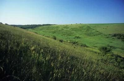
Photo by Thomas A. Meyer/DNR
Barneveld Prairie features a remnant of the vast tallgrass prairies and savannas that once covered most of southern Wisconsin. It is located within the Driftless Area of Wisconsin, a region recognized as the global center for dry prairies and dry-mesic prairies. The natural area lies within the heart of the Military Ridge Prairie Heritage Area (MRPHA) – an extensive grassland landscape supporting a high concentration of prairie remnants. MRPHA also includes patches of untilled prairie pasture and surrogate grasslands that combine with the natural area in providing a habitat for many grassland-restricted species.
It has been identified as the highest priority for landscape-scale grassland protection and management in Wisconsin and represents one of the best opportunities to protect grassland birds that are among the fastest and most consistently declining birds in North America. Three parcels – Thomas Pasture, Thomson prairie, and the Botham tract, currently make up Barneveld Prairie.
The Botham tract is the single largest contiguous property located within MRPHA and contains a diverse mix of prairie remnant, prairie pasture, oak savanna, wetlands, and wooded draws. This gradient of habitat types supports a diversity of plant and animal species, including rare prairie invertebrate specialists.
Thomson Prairie is a dry prairie remnant that was never plowed due to the limestone bedrock lying just below the soil surface making it too difficult to cultivate. More than 68 species of plants have been identified and 34 species of birds nest or feed here. Barneveld Prairie is owned by The Nature Conservancy of Wisconsin and was designated a State Natural Area in 2003.
Very few State Natural Areas have public facilities, but nearly all are open for a variety of recreational activities as indicated below. Generally, there are no picnic areas, restrooms, or other developments. Parking lots or designated parking areas are noted on individual SNA pages and maps. Trails, if present, are typically undesignated footpaths. If a developed trail is present, it will normally be noted on the SNA map located under the Map tab. A compass and topographic map or a GPS unit are useful tools for exploring larger, isolated SNAs.
The good majority of SNAs are isolated and have few or no facilities. Some SNAs have vehicle access lanes or parking lots, but their accessibility may vary depending on weather conditions. Parking lots and lanes are not plowed during winter. Hiking trails may be nonexistent or consist of undeveloped footpaths. A GPS unit or compass and a detailed topographic map are useful tools for exploring larger SNAs.
Non-DNR lands
Entrance fees: For non-DNR-owned SNAs, we are unaware of any vehicle or admission fees. However, please contact the landowner for more information.
Hunting and trapping
This is a non-DNR owned SNA: Opportunities for hunting and trapping depend on the landowner. Partner-owned land may have other rules than DNR (for example, university-owned lands do not allow hunting or trapping). Please contact them directly to find out about their rules for hunting and trapping. You can find a link to other owner websites under the Resources tab.
For hunting opportunities, visit The Nature Conservancy's website: The Nature Conservancy [exit DNR].
Other Activities
Other allowable activities such as - but not limited to camping, geocaching and bicycling are determined by the landowner. Please contact them directly or visit their websites for details.
Location
Iowa and Dane Counties. T6-R5E, Sections 8, 13, 16 17, 22, 24. T6-R6E, Section 18, 19. 955 acres.
Driving directions
For Thomas Pasture: from the intersection of Highway 18/151 and County T west of Barneveld, go south on T 0.4 mile to a parking area east of the road marked with Fire Number 3975. For the Botham tract: from the intersection of County ID and County K in Barneveld, go south on K for 2 miles, then west on Langberry Road nearly 0.6 miles to a parking area north of the road. For Thomson Memorial Prairie: from the intersection of Highway 18 and County F, go south on F about 2 miles to a small parking area west of the road.
The DNR's state natural areas program is comprised of lands owned by the state, private conservation organizations, municipalities, other governmental agencies, educational institutions and private individuals. While the majority of SNAs are open to the public, access may vary according to individual ownership policies. Public use restrictions may apply due to public safety, or to protect endangered or threatened species or unique natural features. Lands may be temporarily closed due to specific management activities.
Users are encouraged to contact the landowner for more specific details. The data shown on these maps have been obtained from various sources, and are of varying age, reliability, and resolution. The data may contain errors or omissions and should not be interpreted as a legal representation of legal ownership boundaries. To create your custom map where you can zoom to a specific location, please use the DNR's Mapping Application
Barneveld Prairie is owned by:
- The Nature Conservancy