Barksdale Ponds
No. 419
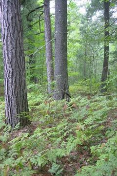
Photo by U.S. Forest Service
Barksdale Ponds is a unique aquatic feature on the edge of a dry, glacial outwash plain. Situated on hilly topography, the numerous soft water seepage lakes and ponds are surrounded by associated emergent, partially submerged and shoreline communities, maturing red and white pine forests, and kettle bogs. The kettles range successionally from the sandy shore, oligotrophic community ponds, through ericad bog ponds, open bog and closed canopy black spruce/tamarack forest. The kettle communities differ in context and content depending on the amount of water and nutrients in the system. Some are more sterile while others support a diversity of plant species.
Located in potholes of pitted outwash sands are treeless bogs. Dominant plants include Spirea, marsh cinquefoil, smartweed, and rattlesnake manna grass. The sphagnum bog mat supports leatherleaf, bog laurel, cotton grass, cranberries, and pitcher plant. Notable species include a species that is only known from several scattered sites in northern Wisconsin. The pine forest contains stands of older white and red pine from 16-18 inches in diameter with scattered large super-canopy pine. The moderate to sparse shrub layer is comprised of hazelnut and pine saplings. The ground flora includes big-leaf aster, bracken fern, wintergreen, blueberries, and bearberry. The area represents the historical vegetation continuum from dry pine barrens to the more mesic forest and has excellent potential for the restoration of jack pine barrens, red pine savanna, and white and red pine forest. Barksdale Ponds is owned by the US Forest Service and was designated a State Natural Area in 2007.
Very few State Natural Areas have public facilities, but nearly all are open for a variety of recreational activities as indicated below. Generally, there are no picnic areas, restrooms, or other developments. Parking lots or designated parking areas are noted on individual SNA pages and maps. Trails, if present, are typically undesignated footpaths. If a developed trail is present, it will normally be noted on the SNA map under the Maps tab. A compass and topographic map or a GPS unit are useful tools for exploring larger, isolated SNAs.
The good majority of SNAs are isolated and have few or no facilities. Some SNAs have vehicle access lanes or parking lots, but their accessibility may vary depending on weather conditions. Parking lots and lanes are not plowed during winter. Hiking trails may be nonexistent or consist of undeveloped footpaths. A GPS unit or compass and a detailed topographic map are useful tools for exploring larger SNAs.
Non-DNR lands
Entrance fees: For non-DNR-owned SNAs, we are unaware of any vehicle or admission fees. However, please contact the landowner for more information.
Hunting and trapping
Other activities
Other allowable activities such as - but not limited to camping, geocaching and bicycling are determined by the landowner. Please contact them directly or visit their websites for details.
Location
Within the Chequamegon-Nicolet National Forest, Bayfield County. T47N-R7W, Section 6. T48N-R7W, Sections 29-32. 337 acres.
Driving directions
The site is located six miles east of the Iron River. Go north on Forest Road 241 for 3.5 miles, then west on Forest Road 242.
The DNR's state natural areas program is comprised of lands owned by the state, private conservation organizations, municipalities, other governmental agencies, educational institutions and private individuals. While the majority of SNAs are open to the public, access may vary according to individual ownership policies. Public use restrictions may apply due to public safety, or to protect endangered or threatened species or unique natural features. Lands may be temporarily closed due to specific management activities.
Users are encouraged to contact the landowner for more specific details. The data shown on these maps have been obtained from various sources, and are of varying age, reliability, and resolution. The data may contain errors or omissions and should not be interpreted as a legal representation of legal ownership boundaries. To create your custom map where you can zoom to a specific location, please use the DNR's Mapping Application.
Barksdale Ponds is owned by:
- US Forest Service