Bakken's Pond
No. 247
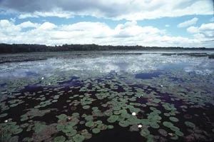
Photo by Thomas A. Meyer/DNR
Bakken's Pond features a cold spring-fed stream with diverse invertebrate and fish fauna and contains emergent aquatic, southern sedge meadow and oak barrens communities. The springs are quite small and scattered - often no larger than a quarter in size. Bordering the stream to the south is an extensive wet meadow consisting predominantly of bluejoint grass, sedges, and the invasive reed canary grass.
Scattered woody vegetation interrupts the extensive sedge meadow with willows, alders, elms, and silver maple. This patchy woody vegetation later grades into a substantial bottomland forest bordering the Wisconsin River. Also present around the wet area southeast of the dike are vast colonies of pickerel-weed and horned pondweed is found in the cold waters of the pond. Bakken's Pond is owned by the DNR and was designated a State Natural Area in 1991.
Very few State Natural Areas have public facilities, but nearly all are open for a variety of recreational activities as indicated below. Generally, there are no picnic areas, restrooms, or other developments. Parking lots or designated parking areas are noted on individual SNA pages and maps. Trails, if present, are typically undesignated footpaths. If a developed trail is present, it will normally be noted on the SNA map under the Maps tab. A compass and topographic map or a GPS unit are useful tools for exploring larger, isolated SNAs.
The good majority of SNAs are isolated and have few or no facilities. Some SNAs have vehicle access lanes or parking lots, but their accessibility may vary depending on weather conditions. Parking lots and lanes are not plowed during winter. Hiking trails may be nonexistent or consist of undeveloped footpaths. A GPS unit or compass and a detailed topographic map are useful tools for exploring larger SNAs.
Entrance fees: Excepting Parfrey's Glen, the Cambrian Outlook in the Dells of the Wisconsin River, SNAs within State Parks and some within State Forests, all other DNR-owned SNAs do not have any admission fee. For more information, see Wis. Admin. Code NR 45. For non-DNR-owned SNAs, we are unaware of any vehicle or admission fees. However, please contact the landowner for more information.
Allowable activities: DNR-owned land
The activities listed below are generally allowed on all DNR-owned SNA lands. Exceptions to this list of public uses, such as SNAs closed to hunting, are noted above and posted with signs on the property site.
- Hiking
- Fishing
- Cross country skiing
- Hunting
- Trapping
- Scientific research (permit required)
- Outdoor education
- Wild edibles (What is this?)
- Pets (Rules)
- Wildlife viewing
Prohibited activities: all SNAs
- Camping and campfires
- Collecting of animals (other than legally harvested species), non-edible fungi, rocks, minerals, fossils, archaeological artifacts, soil, downed wood, or any other natural material, alive or dead.
- Collecting for scientific research requires a permit issued by the DNR
- Collecting of plants including seeds, roots or other non-edible parts of herbaceous plants such as wildflowers or grasses
- Geocaching
- Horseback riding
- Rock climbing
- Vehicles, including bicycles, ATVs, aircraft, and snowmobiles except on trails and roadways designated for their use.
For rules governing state-owned SNAs and other state lands, please consult Chapter NR 45 Wis. Admin. Code [exit DNR].
Location
Within the Lower Wisconsin State Riverway, Sauk County. T8N-R3E, Sections 9, 16. 153 acres.
Driving directions
From the intersection of U.S. Highway 14 and State Highway 23 north of Spring Green, go west on Highway 14 3.0 miles, then south on Dyke Road 0.6 mile, then west on Kennedy Road 1 mile to a DNR parking area south of the road. Or continue west on Kennedy Road 0.5 miles, then south on Laudon Road 0.3 miles, then east on an access lane to a DNR parking area.
The DNR's state natural areas program is comprised of lands owned by the state, private conservation organizations, municipalities, other governmental agencies, educational institutions and private individuals. While the majority of SNAs are open to the public, access may vary according to individual ownership policies. Public use restrictions may apply due to public safety, or to protect endangered or threatened species or unique natural features. Lands may be temporarily closed due to specific management activities.
Users are encouraged to contact the landowner for more specific details. The data shown on these maps have been obtained from various sources, and are of varying age, reliability, and resolution. The data may contain errors or omissions and should not be interpreted as a legal representation of legal ownership boundaries. To create your custom map where you can zoom to a specific location, please use the DNR's Mapping Application.
Aurora Lake is owned by: Wisconsin DNR