Badfish Creek Wet Prairie & Spring Seeps
No. 681
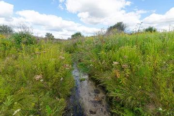
Photo by Josh Mayer
Badfish Creek Wet Prairie and Spring Seeps lie on a broad, low lacustrine plain alongside a partially un-channelized feeder stream to Badfish Creek. Though bordered by ditches to the north and south, the hydrology is intact in the interior of the site. The high-quality wet prairie is dominated by numerous characteristic species including bluejoblue joint, shining aster, giant goldenrod, prairie cordgrass, and Joe-pye-weed.
Tussock sedge and hairy-fruited lake sedge are present but not dominant. Shrub thickets are common in areas where the soils are drier, including at wetland edges. Situated in the central portion and the wettest area is a 10-acre sedge meadow dominated by tussock sedge and lake sedge. While plow lines are visible on the edges of the site, the wettest areas, including the core of the prairie, appear to have never been plowed.
As moderate to high high-quality prairies are exceptionally rare in the state with fewer than 1,000 acres remaining, protection of this site and its intact hydrology is of statewide importance and it ranks among the top 15 wet prairies in Wisconsin. Badfish Creek Wet Prairie and Spring Seeps is owned by the DNR and was designated a State Natural Area in 2016.
Very few State Natural Areas have public facilities, but nearly all are open for a variety of recreational activities as indicated below. Generally, there are no picnic areas, restrooms, or other developments. Parking lots or designated parking areas are noted on individual SNA pages and maps. Trails, if present, are typically undesignated footpaths. If a developed trail is present, it will normally be noted on the SNA map under the Maps tab. A compass and topographic map or a GPS unit are useful tools for exploring larger, isolated SNAs.
The good majority of SNAs are isolated and have few or no facilities. Some SNAs have vehicle access lanes or parking lots, but their accessibility may vary depending on weather conditions. Parking lots and lanes are not plowed during winter. Hiking trails may be nonexistent or consist of undeveloped footpaths. A GPS unit or compass and a detailed topographic map are useful tools for exploring larger SNAs.
Entrance fees: Excepting Parfrey's Glen, the Cambrian Outlook in the Dells of the Wisconsin River, SNAs within State Parks and some within State Forests, all other DNR-owned SNAs do not have any admission fees.
Allowable activities: DNR-owned land
The activities listed below are generally allowed on all DNR-owned SNA lands. Exceptions to this list of public uses, such as SNAs closed to hunting, are noted above and posted with signs on the property site.
- Hiking
- Fishing
- Cross country skiing
- Hunting
- Trapping
- Scientific research (permit required)
- Outdoor education
- Wild edibles (What is this?)
- Pets (Rules)
- Wildlife viewing
Prohibited activities: all SNAs
- Camping and campfires
- Collecting of animals (other than legally harvested species), non-edible fungi, rocks, minerals, fossils, archaeological artifacts, soil, downed wood, or any other natural material, alive or dead.
- Collecting for scientific research requires a permit issued by the DNR
- Collecting of plants including seeds, roots or other non-edible parts of herbaceous plants such as wildflowers or grasses
- Geocaching
- Horseback riding
- Rock climbing
- Vehicles, including bicycles, ATVs, aircraft, and snowmobiles except on trails and roadways designated for their use.
For rules governing state-owned SNAs and other state lands, please consult Chapter NR 45 Wis. Admin. Code [exit DNR].
Location
Within Badfish Creek Wildlife Area, Dane County. T5N-R10E, Section 26. 101 acres.
Driving directions
From the intersection of Highway 14 and Old Stage Road in Rutland, go east on Old Stage Road for 0.25 miles, then east on Old Stone Road for 3.6 miles to a DNR parking area south of the road. Follow two-track south along the channelized stream about one mile to the natural area. The site is bordered by ditches both to the north and south.
The DNR's state natural areas program is comprised of lands owned by the state, private conservation organizations, municipalities, other governmental agencies, educational institutions and private individuals. While the majority of SNAs are open to the public, access may vary according to individual ownership policies. Public use restrictions may apply due to public safety, or to protect endangered or threatened species or unique natural features. Lands may be temporarily closed due to specific management activities.
Users are encouraged to contact the landowner for more specific details. The data shown on these maps have been obtained from various sources, and are of varying age, reliability, and resolution. The data may contain errors or omissions and should not be interpreted as a legal representation of legal ownership boundaries. To create your custom map where you can zoom to a specific location, please use the DNR's Mapping Application.
Badfish Creek Wet Prairie & Spring Seeps is owned by: Wisconsin DNR