Aurora Lake
No. 127
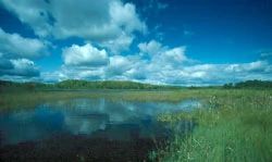
Photo by Thomas A. Meyer/DNR
Aurora Lake is a 94-acre undeveloped, shallow, soft water drainage lake located in an elongated pitted outwash basin. The bottom is primarily muck with a maximum depth of only 4 feet. The fertile water is dominated by wild rice and supports a diversity of submerged and floating leaved aquatic plants including common bladderwort, water-milfoil, pondweeds, waterweed, white and yellow water-lilies, and small bur-reed.
The northern half of the lake consists of a quaking bog mat of sphagnum and sedges and contains the boreal bog orchid. Several islands of tamarack with spruce and red maple occur in the lake while the surrounding wet forest consists of tamarack and black spruce swamp and second-growth white birch. The fishery is northern pike, perch, and sunfish but is subject to winterkill. Bald eagles use the lake along with muskrats, beavers, and waterfowl. Aurora Lake is owned by the DNR and was designated a State Natural Area in 1976.
Very few State Natural Areas have public facilities, but nearly all are open for a variety of recreational activities as indicated below. Generally, there are no picnic areas, restrooms, or other developments. Parking lots or designated parking areas are noted on individual SNA pages and maps. Trails, if present, are typically undesignated footpaths. If a developed trail is present, it will normally be noted on the SNA map under the Maps tab. A compass and topographic map or a GPS unit are useful tools for exploring larger, isolated SNAs.
The good majority of SNAs are isolated and have few or no facilities. Some SNAs have vehicle access lanes or parking lots, but their accessibility may vary depending on weather conditions. Parking lots and lanes are not plowed during winter. Hiking trails may be nonexistent or consist of undeveloped footpaths. A GPS unit or compass and a detailed topographic map are useful tools for exploring larger SNAs.
Entrance fees: Excepting Parfrey's Glen, the Cambrian Outlook in the Dells of the Wisconsin River, SNAs within State Parks and some within State Forests, all other DNR-owned SNAs do not have any admission fees.
Allowable activities: DNR-owned land
The activities listed below are generally allowed on all DNR-owned SNA lands. Exceptions to this list of public uses, such as SNAs closed to hunting, are noted above and posted with signs on the property site.
- Hiking
- Fishing
- Cross country skiing
- Hunting
- Trapping
- Scientific research (permit required)
- Outdoor education
- Wild edibles (What is this?)
- Pets (Rules)
- Wildlife viewing
Prohibited activities: all SNAs
- Camping and campfires
- Collecting of animals (other than legally harvested species), non-edible fungi, rocks, minerals, fossils, archaeological artifacts, soil, downed wood, or any other natural material, alive or dead.
- Collecting for scientific research requires a permit issued by the DNR
- Collecting of plants including seeds, roots or other non-edible parts of herbaceous plants such as wildflowers or grasses
- Geocaching
- Horseback riding
- Rock climbing
- Vehicles, including bicycles, ATVs, aircraft, and snowmobiles except on trails and roadways designated for their use.
For rules governing state-owned SNAs and other state lands, please consult Chapter NR 45 Wis. Admin. Code [exit DNR].
Location
Within the Northern Highland-American Legion State Forest, Vilas County. T41N-R8E, Sections 18, 19. 831 acres.
Driving directions
From the north junction of State Highway 155 and County Highway N in Sayner, go west on N 2.1 miles, then north on Razorback Road 3.8 miles, then west on Aurora Lake Roamiles3 miles to a boat landing on the east side of the lake. The area is best seen by canoe.
The DNR's state natural areas program is comprised of lands owned by the state, private conservation organizations, municipalities, other governmental agencies, educational institutions and private individuals. While the majority of SNAs are open to the public, access may vary according to individual ownership policies. Public use restrictions may apply due to public safety, or to protect endangered or threatened species or unique natural features. Lands may be temporarily closed due to specific management activities.
Users are encouraged to contact the landowner for more specific details. The data shown on these maps have been obtained from various sources, and are of varying age, reliability, and resolution. The data may contain errors or omissions and should not be interpreted as a legal representation of legal ownership boundaries. To create your custom map where you can zoom to a specific location, please use the DNR's Mapping Application.
Aurora Lake is owned by: Wisconsin DNR